Download
1 / 10
100 likes | 239 Views
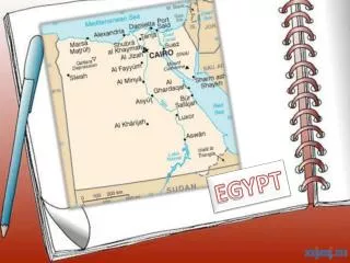
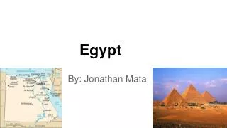
Egypt. Geography Climate Natural Resources. Geography. Africa. Egypt is bordered by: Mediterranean Sea to the north Libya to the west Sudan to the south The Gaza Strip and Israel to the east. www.wikipedia.com. A Transcontinental Nation. www.wikipedia.com.

E N D
Egypt Geography Climate Natural Resources
Africa • Egypt is bordered by: • Mediterranean Sea to the north • Libya to the west • Sudan to the south • The Gaza Strip and Israel to the east www.wikipedia.com
A Transcontinental Nation www.wikipedia.com Suez Canal is a canal in Egypt opened in 1869 Allows water transportation between Europe and Asia without going around Africa Connects the Mediterranean Sea with the Indian Ocean via the Red Sea The canal is owned and maintained by the Suez Canal Authority (SCA) of the Arab Republic of Egypt.
Most important geographic feature: The Nile • Lifeline of ancient Egypt civilization • Major north-flowing river • Longest river in the world • Majority of population • Ends in a large delta that empties into the Mediterranean • Sea. A delta is formed when a channel deposits sediment into another body of water. www.wikipedia.com
Deserts Apart from the Nile Valley, the majority of the landscape is a sandy desert. Sahara and Libyan desert protected Egypt from western threats. www.wikipedia.com
Two Regions: Upper and Lower Lower (northern) Egypt consisted of the Nile River‘s. Delta. Today the Delta is fifteen thousand square miles of alluvium (silt), which has been deposited over the centuries by the annual flooding of the Nile. Upper Egypt was the long, narrow strip of ancient Egypt located south of the Delta. This area is composed of four topographic zones: the Nile River, the floodplain, the low desert, and the high desert. http://www.carnegiemnh.org/exhibits/egypt/orientation.htm
Climate • Temperatures range from 80 -109 • degrees Fahrenheit in summer • Winter temperatures range from 55-70 degrees • Most rainfall occurs between October and March • The Nile floods every year and replenishes Egypt’s soil. This provides a consistent harvest • throughout the year – know as the Gift of the Nile • Khamaseen is a wind that blows from the south bringing in sand and dust www.wikipedia.com
Natural Resources • Crops • Flax grew well in the Nile Valley • Flax was spun into linen cloth • Papyrus was a naturally grown crop • Papyrus was made into writing material • Rocks and Minerals • Quarries of limestone, granite, alabaster, quartzite, flint, steatite • Flint used for weapons and sickles • Steatite stone used to make scarabs (inexpensive charms which held religious meaning) www.historylink101.net/egypt
More Natural Resources • Copper was the main metal used in ancient Egypt • Comes mixed with other metals in an ore form • Heating process called smelting was used to remove impurities from the copper www.historylink101.net/egypt