Download
1 / 18
180 likes | 198 Views
Explore a research paper on path planning in games and simulations, focusing on the innovative method of multi-layered navigation meshes for real-time crowd simulation in complex environments. Discover the algorithms and results of this cutting-edge approach.

E N D
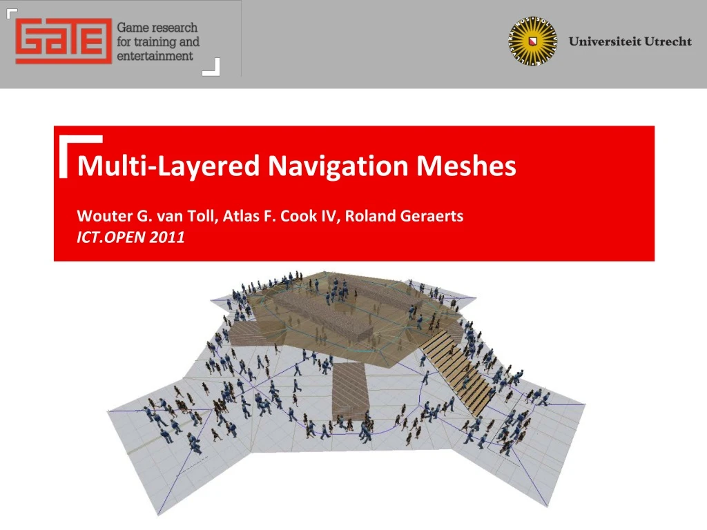
Multi-Layered Navigation MeshesWouter G. van Toll, Atlas F. Cook IV, Roland GeraertsICT.OPEN 2011
Motivation • Path planning in games and simulations • Send virtual characters from start to goal… • …in a smooth an visually convincing way… • …such that they pay attention to other characters • …in real-time, even for large crowds • Typical solution: navigation mesh • Subdivision of the walkable space into 2D polygons • Allows smooth, flexible movement • Should be built automatically…
Research is necessary! • If you think path planning in games is “solved”…
What to do? • What’s the problem? • Human error • Poor data structures • Poor algorithms • What do we want? • A general framework, as automatic as possible • Our framework: path planning with corridors • Automatically built navigation mesh • Global path planning • Local forces Our paper
2D data structure: The medial axis • The set of all points with at least two closest obstacle points • “The middle” of the walkable space • Maximum clearance to obstacles • Preserves connectivity • A useful roadmap • “If there’s no path on the medial axis, then there’s no path at all”
The Explicit Corridor Map (ECM) • Annotated medial axis (Geraerts, 2010) • All event points storea closest obstacle pointon both sides • Exact subdivision of the walkable space A navigation mesh • O(n) storage • O(n log n) build time
The Explicit Corridor Map (ECM) - 2 • Features of the ECM • Global planning • On the MA only: efficient! • Result: path + corridor • Indicative Route Method • (Karamouzas et al., 2009) • Short paths with clearance • Collision avoidance • Local updates • “A Navigation Mesh for Dynamic Environments”, submitted to ICRA ‘12 Efficient, flexible path planning & crowd simulation
Multi-layered navigation? • Crowd simulation is often a 2D problem • Many “3D” environments have a 2D top view (footprint) • But what about multi-layered environments? • It’s not 2D • It’s not 3D • It’s a set of connected 2D problems • Existing methods are approximating • 3D grid: loss of precision • Our method is exact
This paper • We extend the ECM to multi-layered environments • It is constructed automatically • Assumption: layers are given • Can be extracted from 3D data • All 2D algorithms will still work Real-time crowd simulation in multi-layered environments • Recall: The ECM is an annotated medial axis • Our algorithm first builds the multi-layered medial axis • Same annotations: multi-layered ECM
Multi-layered: Definitions • What is a multi-layered environment? • A realistic set of layers and connections • Layer Li • Bounded planar area with a polygonal footprint 2D • Connection CAB • Line segment connecting LA to LB • Half obstacle in LA, half window to LB (access side) • Also appears in LB, with flipped sides • “Realistic” • Layers are logically connected • All footprints are taken from 1 top view C01
Computing the M-L medial axis • Construction algorithm 1. Build the 2D medial axis of each layer… • …treating connections as impassable obstacles • Correct, except ininfluence zones • i.e. the areas with an access side as a closest obstacle • These must be filled in
Computing the M-L medial axis - 2 • Construction algorithm 2. Open up the connections one by one • Choose any connection, say CAB between layers LA and LB • Find the connection sceneSAB: all obstacles adjacent to CAB • Compute the medial axis of SAB • Merge it with the medial axes of LA and LB • Treat LA and LB as one layerfrom now on 3. Repeat until all connections are open Result: 1 continuous medial axis of the whole environment LB CAB LA
Computing the M-L medial axis - 3 • Example • Note: extra vertices on layer transitions • Complexity • n = #obstacle vertices; k = #connections • Storage: O(n) usually O(kn) worst-case • Construction: O(n log n) usually O(kn log n) worst-case • Worst case is very uncommon • Incremental approach handles every case! • Connections may be close together • Order of opening does not matter
Result: Multi-layered ECM • Add closest-point annotations • ECM computed in 46 ms • Real-time multi-layered crowd simulation
Experimental results • Adding obstacles hardly affects stitching time • Connection influence is usually local • Running time increases with #connections • Improvements are possible • We can steer very large crowds in real-time • Tens of thousands of characters
Conclusion • Our incremental algorithm… • builds the medial axis of a multi-layered environment • extends this to the multi-layered Explicit Corridor Map • Our navigation mesh… • is built automatically, given the separate layers • is the first exact mesh for polygonal multi-layered environments • supports efficient and flexible crowd simulation
Future work • What can still be added? • Faster automatic layer extraction • Ongoing MSc projects • Other game actions and environments • Jumping, 3D surfaces, … • There will always be new interesting problems
Thank you! The End