Income Inequality and Health Using Geospatial Big Data
This research examines the relationship between income inequality and health using a geospatial big data approach. The study utilizes a unique tool called GeoHCBT to analyze data from decennial census, American Community Survey, and other variables. The results provide insights into the spatial patterns of income inequality and its impact on health outcomes.

Income Inequality and Health Using Geospatial Big Data
E N D
Presentation Transcript
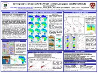
Income Inequality and Health: Expanding our Understanding of State Level Effects by using a Geospatial Big Data Approach Tim Haithcoat1, Eileen Avery1,2, Kelly Bowers1,3, Richard D. Hammer1,3, and Chi-Ren Shyu1,4 (1Informatics Institute; 2Department of Sociology; 3Department of Pathology & Laboratory Medicine; 4Department of Electrical Engineering) This work is supported by the NIH BD2K T32 Training grant (5T32LM012410-02) The Big Data ecosystem is supported by the NSF CNS-1429294 Prepared for BigSurv18 Barcelona, Spain October 27, 2018
Motivation • New directions in big data technology allow scholars to answer new or revisit existing research questions in unique ways • Team currently working on a big data tool “Geospatial Health Context Big Table” (GeoHCBT) • Table contains/will contain variables that include decennial census and American Community Survey data, land use/greenspace, pollution/exposures, crime, and so forth • Here it is used to examine the relationship between income inequality and health in a unique way
Unique Infrastructure • Using Spark big data ecosystem - Clusters • Defined a point file with 318 million points for contiguous 48 states. • Determined Main Common Keys • Census Geography • Zip Code • Watershed • School District • Etc. • Created point summary counts for all geographies to use for analytics Typical Relational DB Typical Geospatial DB
Relevance • The Geospatial Health Context Cube provides: • Health Researchers an integrated big data repository to: • Search - Enable stronger research designs (i.e. develop sampling / surveillance approached). • Explore - Understand spatial interaction models. • Add contextually derived characteristics • Decision Makers with a new tool to evaluate policy implications and focus on areas / populations affected. • Public Health Professionals an ability to identify, mitigate, and potentially prevent health disparities.
Income Inequality and Health • Income inequality hypothesis • Strong and weak versions • Individual level hypotheses (absolute and relative income, deprivation, relative position) • Mechanisms • Issues with geography • Our focus is on ecological income inequality, or the extent of inequality that exists in a given place.
Current Study In this research, we utilize advances in geospatial big data tools and apply them to traditional survey data in order to examine • the extent to which overall income inequality in states as captured by the Gini coefficient • the overall uniformity of this measure within states across counties • the extent to which this inequality is more uniformly high or low are associated with health outcomes in the Behavioral Risk Factor Surveillance System (BRFSS). Results add to a better understanding about the ways that the relationship plays out across space within higher levels of geography such as large political units.
Health Outcomes Physical Health: • Obese if the respondent’s body mass index (BMI) is 30 or above • Diagnosis of chronic obstructive pulmonary disease (COPD) • Diagnosis of cardiovascular disease (CVD) • Fair or poor self-rated health (versus excellent, very good, or good). Mental Health: • Diagnosed with depression (including depression, major depression, or minor depression). • If yes to: “Because of a physical, mental, or emotional condition, do you have serious difficulty concentrating, remembering, or making decisions?” Accessibility: • Restriction to care due to cost (care too expensive) if “yes” to: “Was there a time in the past 12 months when you needed to see a doctor but could not because of cost?”
Gini Coefficient and Uniformity Measures Gini index is a measure of statistical dispersion intended to represent the income or wealth distribution of a unit’s residents, and is the most commonly used measurement of inequality. e.g.: United States (41.5 [2016]); Spain (36.2 [2015]); UK (33.2 [2015]); Brazil (51.3 [2015]); South Africa (63 [2014]); China (42.2 [2012]); Ukraine (25.5 [2015]); Sweden (29.2 [2014]) Developed by the Italian statistician and sociologistCorrado Gini and published in his 1912 paper Variability and Mutability • Uniformity level overall • Uniformly high • Uniformly low
Measure of Spatial Association, Local Moran’s I n equals the total number of counties Positive Value: neighboring county features have either high or low Gini indexes making it a member of a cluster. Negative Value: neighboring features have dissimilar values, which flags this county feature as an outlier. Local Moran’s Iis given as: where gi is an the Gini index for county i, Gis the mean of the Gini index across all counties (n), di,jis the spatial weight (distance) between county i and county j, and:
Moran’s I and Correlation Coefficient rDifferences and Similarities r = 0.71 Correlation Coefficient r • Relationship between two variables Income • Moran’s I • Involves one variable only and is the correlation between variable, X, and the spatial lag of X formed by averaging all the values of X for the neighboring polygons Grocery Store Density Nearby Education r = -0.71 Grocery Store Density
Clustering and Outliers Clusteris developed by assessing each county’s Gini value through evaluating it against its neighborhood of counties within a specified distance threshold. A statistically significant cluster of Gini values represents regionalized areas where surrounding counties share similar values. • A county with a high Gini index surrounded by other highs, would be labeled HH as a member of a high Gini index cluster, and LL for a county with a low Gini index associating with low Gini index cluster. An outlier is then defined relative to a cluster as being a county Gini index that falls within the space of an assembled cluster that is significantly dissimilar to that associated cluster. • A county with a high Gini index would be labeled HL as an outlier if its surrounding counties are primarily low values, or LH as an outlier in which a low value is surrounded primarily by high values. Statistical significance for this assessment was set at 95% confidence level.
Controls and Analytic Strategy • Controlled for MHI, health insurance (state and individual), % on SNAP, age, race, ethnicity, education, income, relationship status, health behaviors • Hierarchical logistic regression models. Random intercepts. Individuals nested within states. Weights utilized.
Hierarchical Logistic RegressionsHealth Outcomes on Measures of Inequality and Uniformity in Inequality
Conclusions • Income inequality, as captured by the Gini coefficient, did not significantly increase the odds of any outcome. • Residents of states with more uniformly high levels of inequality across space are more likely to report: • below average health, • cardiovascular disease, • difficulty concentrating • lack access to care due to cost. • However, Gini reduced the odds of obesity and depression, and residents with more uniformly low inequality states were more likely to be obese. • These findings, while disputing the IIH, suggest inequality, and its distribution across space, matters differently for different health outcomes. • The nature of the dispersion of inequality across geographies is an important variable to consider when evaluating the IIH.
Future Directions • Grouping Analysis based on positive and negative variable correlations / associations with Gini Index • Explore other inequality measures • Explore the stability of these relationships across various geographic levels Negative Positive