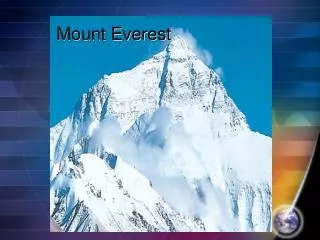
Aoraki/Mount Cook
580 likes | 811 Views
Aoraki/Mount Cook. Evolution. Step one. Step 2. Step 3. Step 4. Glaciers. Notes on what a glacier is + how a glacier forms SIHCAorakiMC glaciers.doc Glacial recipe SIHCglacier formation 1.doc Drawing on page 8 of El Bible Discussion of Key terms. Terms.

Aoraki/Mount Cook
E N D
Presentation Transcript
Aoraki/Mount Cook Evolution
Glaciers • Notes on what a glacier is + how a glacier forms • SIHC\AorakiMC glaciers.doc • Glacial recipe • SIHC\glacier formation 1.doc • Drawing on page 8 of El Bible Discussion of Key terms.
Terms • Neve (accumulation zone) = The area where the ice accumulates. • Bedrock = The rock that lies below the snow. In MC what will it be? • Ablatation Zone = Area where the snow is beginning to be melted away and lost (area below the firn line) • Moraine = Material that gets transported then deposited by the glacier.
Precis Sketch Drawing • Divide your picture of MC on page 9 into 8ths with doted ruled lines. • In your book draw a similar area once again divided into 8ths. • Now using the intersection of the lines you have ruled in our diagram draw an accurate precis sketch of MC.
How glaciers move • These rivers of ice flow at around 100,000 times slower than water and they do so at different speeds. • So how do they move? Ice Skater eg on Youtube. • Notes on how a glacier moves • SIHC\How Glaciers move.doc
Glacier features • Crevasse: This is an umbrella term to describe a number of different features. A Crevasse is a crack in the ice created by tension. • Often crevasses are 70 metres deep. • Transverse Crevasse = Go from one side of the glacier to the other.
More features • Longitudinal crevasse found near the terminus or end of the glacier. The show the glacier is spreading outwards. • Marginal crevasse which point 40 degrees upstream. • Bergschrund = A deep crevasse formed at the cirque.
Moraine and Till • Till = Rock debris carried by glaciers. • Moraine = The feature created by deposited till. Moraine shows where glaciers once were. • Lateral Moraine = Found at the edges of glaciers. Debris usually originates from rockfalls and avalanches. Tasman glacier has impressive lateral moraines.
More Moraines • Medial Moraines = Formed by lateral moraines coming together when a tributary glacier flows into a main glacier. • Surface Moraines = Occur most at the terminus of a glacier because ice melt exposes them. • Eglacial Moraine and subglacial moraine = These are carried within and under the glacier. The greatest bulk of the debris is carried by these. • Terminal moraine = The remains of a moraine that has receeded. • Firnline and equilibrium line = Transition between the neve and melt zones.
Melt-water features • Surface Moraines at Tasman glacier are 1-2 metres deep. They cover sinkholes or moulins. • A moulin starts as a small pothole that eventually deepen to join up with melt-water conduits that form the glacial plumbing system. On Tas glacier Moulins have expanded into large grey circular lakes. • These systems eventually find their way to the base of the glacier and they get dischard themselves into the fluvialglacial system carrying rock flour. The amount they discharge is enormous at present the outwash gravels are 500-1000 metres deep.
Icefalls • Icefalls occur at Tasman glacier above the glacier. This is called the Hochstetter icefall. • Icefalls usually occur just below the neve.
Activity • Create your own mountain and glacier system. • Your Mountain can be called whatever you want (within reason) and each glacier or glacial feature can be called what you want (within reason). • On an a4 sheet of paper you are to create this glacier and accuratly add to it the different features glaciers create.
Surface Processes • Either created by abrasion or plucking. • Abrasion = Scraping • Plucking = Pulling of rocks from bedrock. • Small Scale features: Striations, Polished rock, pot holes • Created by glacier running across the rock and either scraping or smoothing. Pot holes created by the glacier plumbing system.
Large Scale Features • When Glaciers move they carve out the landscape they travel over. Due to the mass material they move they create u shaped valleys. Rivers don’t carve out as much and therefore only create v-shaped valleys. • U-shaped valleys often get damned up by terminal moraine which creates finger lakes. Lakes Tekapo, Pukaiki and Ohau are finger lakes.
Conitued • The Cirque: Where the neve/accumulation zone was. Often contains a small lake called a tarn. • Roche Moutonee: Foliage hill provides an eg of this. It is a hill under the glacial ice. One side is a smooth gradual slope the other is a rough plucked cliff side.
Continued • Hanging Valleys: Created by tributary glaciers not cutting as deep a path as the main glacier therefore hang above. • Arete: South ridge at MC provides a good example of this. It is a ridge between two crique’s • Col: A pass where 2 Cirques converge. Tuckett Col is a good example of this.
Glacial transportation • Glaciers act as massive conveyor belts. They transport both fine and large material down the glacial system. Around the terminus products of glacial transportation are ever present. The Tasman glacier used to extent much further and material found at the snout of this glacier showed where it used to flow to.
Human Modification of the environment. • Copy in the glacier system and explain it briefly underneath. • Glaciers work on the equation of accumulation vs. ablation. This is called the Mass budget. • This is how Humans have affected glaciers. Global warming has heated the earth which has meant that less snow is being deposited in the neve and more is being melted. This affects the glaciers ability to erode, transport and deposit.
Continued • Copy in paragraph written in italics. • When Answering these Questions be sure to include your question within the answer!!!! • Using text explain the following terms: downwasting, ablation, accumulation. • How much of its volume is Tasman glacier losing each year? • Describe what you think a trimline is. • How much has the Tasman glacier dropped since 1895? • At the Muellar glacier why don’t the melt waters breach the moraine. • What glacier mentioned has a terminus that hasn’t receeded yet. • How much has the temp at mount cook risen since the 1900’s • How has El Nino affected glaciers in the neighbouring regions?
Humans and Glaciers • Global Warming created by the Greenhouse affect has led to some recession in glaciers. This combined with El Nino, La Nina and the Southern Oscillation has meant the amount caused by Humans is difficult to tell.
Climate • Air Pressure: Air Pressure always moves from areas of high pressure to low pressure. • Wind: The movement of air from low pressure to high pressure. • Precipitation: Moisture in the atmosphere rain, hail snow, fog. Precipitation occurs when air is forced to rise and therefore it cools and condenses to dew point.
Rainfall • There are three different types of rainfall: Frontal when two fronts collide, convection when a water source gets evaporated and orographic. • Orographic rainfall is the focus for Mt. Cook. • This is because the Southern Alps act as a massive barrier to the moisture laden westerly winds that flow from the Tasman sea.
Climate • The west coast of New Zealand receives 7600mm of rainfall annually. • The area to the east of the SIHC is the driest in the country because of the rain shadow provided by the southern alps.
Vegetation (DW) • The levels of vegetation at Aoraki Mt. Cook differ vastly. At the top of the 3754m peak there is no vegetation. To the west at the foothills there is temperate rainforest and to the East there is grasslands what is the reasoning for these differences?
Vegetation • Life is hard for plants to survive at Aoraki Mt. Cook. • The climate is cold and blustery • The soil is thin and infertile • The landscape is steep • The alitude is high • Plants need to be resilient to survive these conditions • What would be the issues with each of the points above for plants?
vegetation The temperatures at Mt. Cook drop around a degree every 200 metres. This inhibits the plants that can grow and the process of plants growing at different heights is called altitudinal zonation. At Aoraki Mt. Cook there is over 400 different species of plants. At the lower altitudes (up to 1300m) the temperate rainforest grows. This includes species of podocarps like: Kahikatea.
Higher up • From 1300-1900m asl smaller shrub like plants dominate these include: • Spear grass, Mt. Cook lily the worlds biggest lily, Snow tussocks, vegetable sheep. • Above 1900m 14 different types of Lichens have been found.
Cultural perspectives and Human activity in the SIHC • Culture is an important geographic idea and is simply defined as a ‘common way of life’ • Cultural perspective = perception • How people view things differently.
Land Use SIHC • Agriculture • Intensive farming – is it an option in the SIHC? Why/why not? • Farmers in the SIHC have developed a farming system known as extensive pastoralism • Farms are characteristically large and carry few sheep because of the difficult environment • Sheep are the main animal grazed, for wool production rather than meat • Fodder crops are grown to feed livestock in winter when grass growth slows down or is under snow.