Download
1 / 36
360 likes | 451 Views
A Product Development Team for Snow and Ice Climate Data Records. Jeff Key Cryosphere Team NOAA/NESDIS Madison, WI Phone: 608-263-2605 Email: Jeff.Key@noaa.gov. CDR Annual Review, 4-5 Aug 2010, Asheville. Outline. Brief Project Overview Approach (1-2 slides)

E N D
A Product Development Team for Snow and Ice Climate Data Records Jeff Key Cryosphere Team NOAA/NESDIS Madison, WI Phone: 608-263-2605 Email: Jeff.Key@noaa.gov CDR Annual Review, 4-5 Aug 2010, Asheville
Outline • Brief Project Overview • Approach (1-2 slides) • Results/Accomplishments (1-3 slides) • Validation Strategy/Results (1-2 slides) • Algorithm/Product Maturity • Issues/Risks & Work-Off Plans • Schedule • Research-to-Operations or Delivery Plan • Resources
Overview: Goals The cryosphere product development team will coordinate the generation, validation, and archival of fundamental and thematic snow and ice climate data records, building on existing products and efforts as appropriate. Our goal is to refine, extend, validate, document, and archive visible, infrared, and passive microwave cryosphere products. We will merge the existing data into consistent time series, and use these series as a basis for transitioning to NPP and JPSS products. We will build on existing efforts, coordinating with other funded products, as appropriate.
Overview: Deliverablesand Source Data • Sea ice concentration and extent (SSM/I and AMSR-E) • Sea ice motion (AVHRR and SSM/I or AMSR-E) • Sea ice thickness/age (AVHRR, MODIS, SSM/I and AMSR-E) • Ice/snow surface temperature (AVHRR and MODIS) • Ice/snow surface broadband albedo (AVHRR and MODIS) • Surface shortwave and longwave radiation (AVHRR and MODIS) • Snow cover/extent (AVHRR, SSM/I, AMSR-E) • Surface ice melt onset/freeze-up (SMMR, SSM/I, AMSR-E)
Overview: ECVs • GCOS ECVs addressed– • Sea ice • Surface temperature • Surface albedo • Snow cover • Cloud properties • Surface radiation budget • Current/expected user communities • Climate modeling and prediction, energy, transportation, fisheries
Personnel • Jeff Key, NOAA/NESDIS • Xuanji Wang, University of Wisconsin • Yinghui Liu, University of Wisconsin • James Maslanik, University of Colorado • Walt Meier, University of Colorado • Charles Fowler, University of Colorado • Julienne Stroeve, University of Colorado • William Emery, University of Colorado • Mark Tschudi, University of Colorado • Dorothy Hall, NASA/GSFC
Sea ice concentration/extent products • 30+ year record from several sensors • Nimbus-7 SMMR (1978-1987) • DMSP SSM/I-SSMIS series (1987-present) • NASA EOS AMSR-E (2002-present) • JAXA GCOM-W AMSR2 (2011) • SMMR-SSM/I-SSMIS intercalibrated • Several algorithms • NASA Team • Bootstrap • NASA Team 2 • Bristol, Norsex, Cal/Val, ARTIST, etc. • No clearly superior algorithm • Combined algorithms? 14 March 2010 Archived at NSIDC (NT2 for AMSR-E only)
Ice Concentration and Ice Mask from vis/IR • Algorithm: • Ice mask: Group threshold tests • Ice concentration: tie-point algorithm • Sensors: • AVHRR (MODIS) near visible and near infrared channel data, and surface temperature retrieved. • Area coverage: • Arctic and Antarctica. • Time Period: • 1982~2004, currently. • Spatial Resolution: • 25 km (can be up to 1km). Sea Ice Concentration
Ice Motion • Algorithm: • Ice motion based on Maximum Cross Correlation computations from SMMR, SSM/I, and AVHRR have been computed and are available on a daily and weekly composite basis back to 1982. • Sensors: • The product stopped using the SSM/I as the primary data source in Dec 2008 and continued with the SSMIS. • The product has been merged with ice buoy trajectories over the same time period.
Sea ice thickness/age - energy budget Sea Ice Thickness • Algorithm: • One-dimensional Thermodynamic Ice Model (OTIM) based on the surface energy budget at the equilibrium state. • Sensors: • Uses other derived products. • Area coverage: • Arctic and Antarctic • Time period: • 1982~2004, currently • Spatial resolution: • 25 km
Ice Age - Lagrangian Tracking • Algorithm: • Lagrangian tracking of ice to determine age. Empirical relationship between ice age and thickness. • Sensors: • APP ice motion fields • Time period: • 1982~2004, currently
Ice/snow surface temperature Surface Skin Temperature • Algorithm: • Split window technique using AVHRR channel 4 and 5 with cloud adjustment for cloudy sky condition for snow and ice surface. • Sensors: • AVHRR channel 4 & 5 or equivalent sensors with near-infrared and atmospheric window channels. • Area coverage: • Arctic and Antarctic • Time period: • 1982~2004, currently • Spatial resolution: • 25 km
Ice/snow surface broadband albedo Surface Broadband Albedo • Algorithm: • Using AVHRR channel 1 and 2 with cloud adjustment for cloudy sky condition. • Sensors: • AVHRR channel 1 & 2 or equivalent sensors with optical channels. • Area coverage: • Arctic and Antarctic • Time period: • 1982~2004, currently • Spatial resolution: • 25 km
Surface shortwave and longwave radiation • Algorithm: • Forward radiative transfer calculation using a neural network version of radiation transfer model and derived products for clouds and surface properties. • Sensors: • All AVHRR channels • Area coverage: • Arctic and Antarctic • Time period: • 1982~2004, currently • Spatial resolution: • 25 km Surface shortwave radiation flux, downward
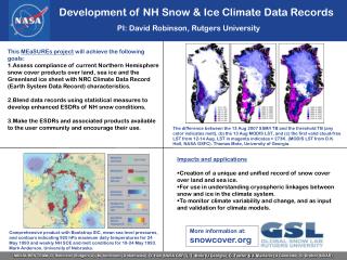
Northern Hemisphere Snow Extent Earth System Data Records Assess compliance of current NH snow cover products over land, sea ice and the Greenland ice sheet with NRC Climate Data Record (Earth System Data Record) characteristics Blend data records using statistical measures to develop enhanced, ESDRs of NH snow conditions Make the ESDRs and associated products available to the user community via an existing web site (http://climate.rutgers.edu/snowcover/) and encourage their use.
Melt Onset • Drobot-Anderson Algorithm: • Passive microwave temperature difference between 19 and 37 GHz channels • Sensors: • SMMR, SSM/I (future: SSMIS, AMSR-E) • Time period: • 1982-2007, currently • Smith, Markus, Miller Algorithm: • Passive microwave temperature difference between 19 and 37 GHz channels. Includes “early melt” and freeze-up parameters as well. • Sensors: • SMMR, SSM/I (future: SSMIS, AMSR) • Time period: • 1982-2008, currently
Results/Accomplishments (1) • Daily data quality fields are being implemented in the passive microwave ice concentration CDR. The fields will include data values (e.g., concentration difference between algorithms) and quality flags. Metadata fields have now been developed, based on ISO 19115-2. • Near-real-time sea ice products are being produced from the newest DMSP sensor, the F17 SSMIS. • Ice motion vectors have been calculated from AMSR-E and compared to those from SSM/I, with the intent of generating motion vectors for the full AMSR-E time series. • The sea ice motion time series has been updated through July 2010. These data to incorporate Arctic Ocean Buoy Program buoy drift. • The passive microwave sea ice concentration products provide the basis for regular scientific analysis of conditions at the NASA and NOAA funded “NSIDC Arctic Sea Ice News and Analysis” (ASINA) website. The passive microwave sea ice products also provide input and a baseline for evaluation for the ARCUS/SEARCH Sea Ice Outlook.
Results/Accomplishments (2) • The Lagrangian tracking ice age product has been updated through July 2010, with the improved vectors used for age calculation through June 2010. An accuracy/quality assessment of the ice age data has been completed. • APP-x has been reprocessed. Many algorithm refinements have been made for the extended AVHRR Polar Pathfinder (APP-x), including the addition of ice concentration and thickness/age. Validation efforts have provided quantitative error assessments. • A comparison of surface temperature over Greenland from AVHRR and MODIS has shown that APP-x underestimates the temperature relative to MODIS, with a lower bias observed during the summer months. In contrast, a comparison of the APP-x temperature data with drifting buoy temperatures show good agreement during the non-melt period, with a slight bias during melt.
Results/Accomplishments (3) • Field measurements of the directional reflectance of snow, exposed ice, ponded ice, and combinations of the above are being processing in order to lay the framework for improving the albedo retrieval by improving the angular dependence model (ADM) used to convert the directional measurement to an albedo. • A comparison between Northern Hemisphere snow cover using NOAA and Rutgers snow maps from 1966 through the MODIS era (2000 – present) has begun. • A public forum was held at the State of the Arctic Conference (Miami, March 2010) to solicit feedback from the scientific community on the proposed snow and ice climate data records. A workshop on sea ice CDRs will be held in the U.S. later this year. A WCRP workshop that will focus on essential climate variables, including sea ice, is being planned for 2011.
Results/Accomplishments:Climate Applications • The loss of the oldest, thickest Arctic sea ice continues at a record pace through 2010. Viewed along with model estimates of low ice volume at the start of the melt season, it is likely that ice extent for September 2010 will continue the recent history of extreme seasonal minima. The thinner ice cover is responding more dramatically to synoptic-scale variation both in the winter and summer. • It was found that changes in sea ice concentration and cloud cover played major roles in the magnitude of recent Arctic surface temperature trends. Significant surface warming associated with sea ice loss accounts for most of the observed warming trend. In winter, cloud cover trends explain most of the surface temperature cooling in the central Arctic Ocean. • The APP-x product was recently used to study of controls on snow albedo feedback (SAF), which is important for assessing the validity of feedbacks in global climate models.
PM Sea Ice Concentration Validation Approach • Several independent validation case-studies over many years, e.g.: • Andersen et al., JGR, 2007: intercompared six algorithm products • Meier, IEEE TGRS 2005: compared four algorithms against AVHRR • Cavalieri et al., IEEE TGRS, 2003: AMSR-E with Landsat and airborne imagery • Steffen et al., AGU Geophys. Monograph 68: comparison with Landsat • General uncertainties 5-10% concentration, but higher biases under many conditions (melt, thin ice, near ice edge) • Validation conclusions depend on location and season of case studies • Relative performance of algorithms varies with conditions and no one algorithm clearly superior • Best approach for internal, NRT validation is running secondary algorithms and ancillary products (e.g., melt onset) to provide a data uncertainty/quality estimate at each grid cell • Key ancillary parameters selected and will soon be implemented and made available for review by users • Algorithm workshop planned for spring 2011 to bring algorithm producers and users together to evaluate algorithms and data quality parameters
Ice Age/Thickness Validation Approach • Lagrangian Ice Age • Compare spatial patterns of ice age to aircraft data from multiple existing efforts (NASA AMSRIce03, NASA AMSRIce06 validation campaigns, IceBridge flights (imagery and LIDAR profiling), recent Characterization of Arctic Sea Ice Experiment UAS flights (imagery, LIDAR, radar). • Examine temporal and spatial consistency compared to complementary satellite data (ICESat, QuikSCAT, AMSR-E, ENVISAT). • Evaluate effects of using AMSR-E derived ice motion fields to test sensitivity to variations in ice motion accuracies. • Energy Budget Ice Thickness: • OTIM retrieved ice thickness with AVHRR, MODIS and SEVIRI were validated with in-situ observations, e.g., from submarine, mooring, and meteorological stations (Xuanji Wang, Jeffrey Key, and Yinghui Liu (2010), A thermodynamic model for estimating sea and lake ice thickness with optical satellite data, J. Geophys. Res., revision submitted, April 2010.)
IST, Albedo, Radiation Validation Approach • APP-x products were validated with in-situ observations, e.g., from SHEBA and meteorological stations (Xuanji Wang and Jeffrey R. Key, 2005, Arctic Surface, Cloud, and Radiation Properties Based on the AVHRR Polar Pathfinder Data Set. Part I: Spatial and Temporal Characteristics, J. Climate, Vol.18, No.14, 2558-2574, 2005.) • Sea ice concentration from vis/IR was validated with ice products from microwave observations, and retrieved sea ice motion was validated with in-situ buoy data. This is ongoing in GOES-R and NPP cal/val projects.
Sea Ice Motion Validation Approach • Product has been validated vs. various data sets by multiple investigators. These efforts will continue. • The effects of loss of tracking during parts of the summer (due to surface melt) on ice motion errors is being evaluated. • Comparisons to modeled surface winds.
Maturity Index: Summary (Qualitative average. Details on following slides) Sea ice concentration and extent: 5 Sea ice motion: 5 Sea ice age – Lagrangian: 3 Sea ice thickness/age – energy budget: 4 Ice/snow surface temperature: 4.5 Ice/snow surface broadband albedo: 4.5 Surface shortwave/longwave radiation: 4.5 Snow cover/extent: 5 Surface ice melt onset/freeze-up: 4
v. June 2010 CDR Maturity Matrix – Sea Ice Concentration
v. June 2010 CDR Maturity Matrix – Sea Ice Motion
v. June 2010 CDR Maturity Matrix – Lagrangian Ice Age
v. June 2010 CDR Maturity Matrix – Energy Budget Ice Thickness
v. June 2010 CDR Maturity Matrix - Ice/Snow Surface Temperature
v. June 2010 CDR Maturity Matrix - Ice/Snow Surface Albedo
v. June 2010 CDR Maturity Matrix – Surface Radiative Fluxes
Issues/Risks & Work-Off Plans • Current or possible future problems: • Many difference passive microwave sea ice concentration products. • Ice age from Lagrangian tracking is less mature, but potentially valuable. • Extending APP (hence APP-x) in time beyond 2009 is not funded. • Sea ice thickness from the energy budget approach is currently a nighttime-only product. • Approaches to work around or mitigate the problem(s): • Continue to compare ice concentration products. Possibly include differences in quality fields. • Continue validation efforts for ice age. • Implement APP processing at CIMSS. • An extension of the energy budget model to daytime conditions is being developed.
Schedule Year 2 • Reprocess APP-x products from 1982 to present. Update and extend APP-x metadata and documentation. • Passive microwave: Complete the development of data quality fields and request feedback from the community, host a CliC-funded workshop on sea ice concentration products, and implement metadata fields and produce for the current sea ice products. Investigate other sea ice algorithms methods for possible inclusion in the concentration CDR and/or data quality fields. • Update ice age products and continue validation. • Work with Rutgers (D. Robinson) in combining MODIS and Rutgers snow cover. Year 3 • Extend APP-x and passive microwave products through 2011 and implement routine updating. • Deliver products and documentation to the appropriate data center. • Transition APP-x algorithms to NPP VIIRS product processing, and evaluate the performance for NPP VIIRS products.
Research-to-Operations or Delivery Plan Deliveries will include • Datasets in required format • Dataset and metadata documentation • Algorithm documentation • Testing and validation data and results Delivery schedule TBD
Resources • Number of personnel employed for project • CIMSS & STAR: 3 (~1.2 FTE) • CU/CCAR & NSIDC: 5 (~2.0 FTE) • NASA GSFC: 1 (~0.1 FTE) • Key equipment or observatories used • None • Key collaborating projects or personnel • EUMETSAT SAF, NASA APP, NSIDC, MODIS & Rutgers snow cover projects, GOES-R snow/ice, WCRP CliC • NOAA points-of-contact or collaborators, as applicable • Jeff Key, NOAA/NESDIS/STAR, Madison, WI • Target NOAA Data Center: • NCDC, NSIDC (not strictly NOAA)