Download
1 / 1
10 likes | 233 Views
National Snow and Ice Data Center. “Long-Lived Digital Data” for NSF Scientists. Ballagh, L., Tsukernik, M., Judy, C., Dichtl, R., Bauer, R., Parsons, M., Zhang, T., Sheffield, B., and Barry, R. http://nsidc.org.

E N D
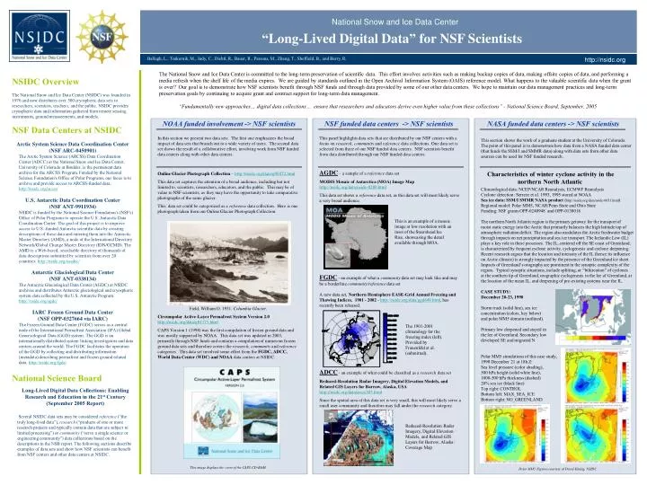
National Snow and Ice Data Center “Long-Lived Digital Data” for NSF Scientists Ballagh, L., Tsukernik, M., Judy, C., Dichtl, R., Bauer, R., Parsons, M., Zhang, T., Sheffield, B., and Barry, R. http://nsidc.org • The National Snow and Ice Data Center is committed to the long-term preservation of scientific data. This effort involves activities such as making backup copies of data, making offsite copies of data, and performing a media refresh when the shelf life of the media expires. We are guided by standards outlined in the Open Archival Information System (OAIS) reference model. What happens to the valuable scientific data when the grant is over? Our goal is to demonstrate how NSF scientists benefit through NSF funds and through data provided by some of our other data centers. We hope to maintain our data management practices and long-term preservation goals by continuing to acquire grant and contract support for long-term data management. NSIDC Overview The National Snow and Ice Data Center (NSIDC) was founded in 1976 and now distributes over 500 cryospheric data sets to researchers, scientists, teachers, and the public. NSIDC provides cryospheric data and information gathered from remote sensing instruments, ground measurements, and models. “Fundamentally new approaches… digital data collections… ensure that researchers and educators derive even higher value from these collections” - National Science Board, September, 2005 NOAA funded involvement -> NSF scientists NSF funded data centers -> NSF scientists NASA funded data centers -> NSF scientists NSF Data Centers at NSIDC In this section we present two data sets. The first one emphasizes the broad impact of data sets that branch out to a wide variety of users. The second data set shows the result of a collaborative effort, involving work from NSF funded data centers along with other data centers. Online Glacier Photograph Collection – http://nsidc.org/data/g00472.html This data set captures the attention of a broad audience, including but not limited to, scientists, researchers, educators, and the public. This may be of value to NSF scientists, as they may have the opportunity to take comparative photographs of the same glacier. This data set could be categorized as a reference data collection. Here is one photograph taken from our Online Glacier Photograph Collection: Field, William O. 1931. Columbia Glacier. Circumpolar Active-Layer Permafrost System Version 2.0http://nsidc.org/data/g01175.html CAPS Version 1 (1998) was the first compilation of frozen ground data and was mostly supported by NOAA. This data set was updated in 2003, primarily through NSF funds and contains a compilation of numerous frozen ground data sets and therefore covers the research, community and reference categories. This data set involved some effort from the FGDC, ADCC, World Data Center (WDC) and NOAA data centers at NSIDC. This image displays the cover of the CAPS CD-ROM. This panel highlights data sets that are distributed by our NSF centers with a focus on research, community and reference data collections. One data set is selected from three of our NSF funded data centers. NSF scientists benefit from data distributed through our NSF funded data centers. AGDC – a sample of a reference data set MODIS Mosaic of Antarctica (MOA) Image Map http://nsidc.org/data/nsidc-0280.html This data set shows a reference data set, as this data set will most likely serve a very broad audience. FGDC - an example of what a community data set may look like and may be a borderline community/reference data set A new data set, Northern Hemisphere EASE-Grid Annual Freezing and Thawing Indices, 1901 - 2002 - http://nsidc.org/data/ggd649.html, has recently been released. ADCC - an example of what could be classified as a research data set Reduced-Resolution Radar Imagery, Digital Elevation Models, and Related GIS Layers for Barrow, Alaska, USA http://nsidc.org/data/arcss303.html Since the spatial area of this data set is very small, this will most likely serve a small user community and therefore may fall under the research category. This section shows the work of a graduate student at the University of Colorado. The point of this panel is to demonstrate how data from a NASA funded data center (that funds the SSM/I and SMMR data) along with data sets from other data sources can be used for NSF funded research. • Arctic System Science Data Coordination Center (NSF ARC-0450901) • The Arctic System Science (ARCSS) Data Coordination Center (ADCC) at the National Snow and Ice Data Center, University of Colorado at Boulder, is the permanent data archive for the ARCSS Program. Funded by the National Science Foundation's Office of Polar Programs, our focus is to archive and provide access to ARCSS-funded data. http://nsidc.org/arcss/ • U.S. Antarctic Data Coordination Center • (NSF ANT-9911934) • NSIDC is funded by the National Science Foundation's (NSF's) Office of Polar Programs to operate the U.S. Antarctic Data Coordination Center. The goal of this project is to improve access to U.S.-funded Antarctic scientific data by creating descriptions of these data and entering them into the Antarctic Master Directory (AMD), a node of the International Directory Network/Global Change Master Directory (IDN/GCMD). The AMD is a Web-based, searchable directory of thousands of data descriptions submitted by scientists from over 20 countries. http://nsidc.org/usadcc/ • Antarctic Glaciological Data Center • (NSF ANT-0338134) • The Antarctic Glaciological Data Center (AGDC) at NSIDC archives and distributes Antarctic glaciological and cryospheric system data collected by the U.S. Antarctic Program. http://nsidc.org/agdc/ • IARC Frozen Ground Data Center • (NSF OPP-0327664 via IARC) • The Frozen Ground Data Center (FGDC) serves as a central node of the International Permafrost Association (IPA) Global Geocryological Data (GGD) system. The GGD is an internationally distributed system linking investigators and data centers around the world. The FGDC facilitates the operation of the GGD by collecting and distributing information (metadata) describing permafrost and frozen ground related data. http://nsidc.org/fgdc/ Characteristics of winter cyclone activity in the northern North Atlantic Climatological data: NCEP/NCAR Reanalysis, ECMWF Reanalysis Cyclone detection: Serreze et al. 1993, 1995 stored at NOAA Sea ice data: SSM/I SMMR NASA product (http://nsidc.org/data/nsidc-0051.html) Regional model: Polar MM5, NCAR/Penn State and Ohio State Funding: NSF grants OPP-0240948 and OPP-0138018 This is an example of a mosaic image at low resolution with an inset of the Steershead Ice Rise, showcasing the detail available through MOA. The northern North Atlantic region is the primary getaway for the transport of moist static energy into the Arctic that primarily balances the high latitude top of atmosphere radiation deficit. The region also modulates the Arctic freshwater budget through impacts on net precipitation and sea ice transport. The Icelandic Low (IL) plays a key role in these processes. The IL, centered off the SE coast of Greenland, is characterized by frequent cyclone activity, cyclogenesis and cyclone deepening. Recent research argues that the location and intensity of the IL (hence its influence on Arctic climate) is strongly impacted by the presence of the Greenland ice sheet. Impacts of Greenland’s orography are prominent in the synoptic complexity of the region. Typical synoptic situations, include splitting, or “bifurcation” of cyclones at the southern tip of Greenland, orographic cyclogenesis in the lee of Greenland, at the location of the mean IL, and deepening of pre-existing systems near the IL. CASE STUDY: December 20-23, 1990 Storm track (solid line), sea ice concentration (colors, key below) and polar MM5 domain (outlined). Primary low deepened and stayed in the lee of Greenland. Secondary low developed SE and migrated N The 1901-2001 climatology for the freezing index (left). Provided by Frauenfeld et al. (submitted). Polar MM5 simulations of this case study, 1990 December 21 at 18h Z: Sea level pressure (color shading), 500 hPa height (solid white line), 1000-500 hPa thickness (dashed) 20% sea ice (black line) Top right: CONTROL Bottom left: MAX_SEA_ICE Bottom right: NO_GREENLAND National Science Board Long-Lived Digital Data Collections: Enabling Research and Education in the 21st Century (September 2005 Report) Several NSIDC data sets may be considered reference (“the truly long-lived data”), research (“products of one or more research projects and typically contain data that are subject to limited processing”) or community (“serve a single science or engineering community”) data collections based on the descriptions in the NSB report. The following sections describe examples of data sets and show how NSF scientists can benefit from NSF centers and other data centers at NSIDC. Reduced-Resolution Radar Imagery, Digital Elevation Models, and Related GIS Layers for Barrow, Alaska: Coverage Map Polar MM5 Figures courtesy of David Kindig, NSIDC