Download
1 / 77
790 likes | 954 Views
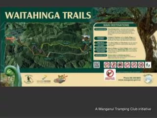
A Wanganui Tramping Club initiative. Location. The trails are on approx 700ha of land owned by the Wanganui District Council and was previously used as a water supply for the city. Part of the block is in pines and is not a feature of these trails. The rest of the land is in native forest.

E N D
The trails are on approx 700ha of land owned by the Wanganui District Council and was previously used as a water supply for the city. Part of the block is in pines and is not a feature of these trails. The rest of the land is in native forest.
The trails have been designed primarily as dictated by the landscape. This has eventuated into a useful range of opportunities, from having an easy picnic in the dell a few minutes from the car park, to the walk to the dam which is designed for those capable of four or more hours of walking.
Half a kilometre from the car park is the easiest experience, the Picnic Dell, a sheltered clearing 200m off the quarry road.
Beyond the picnic dell is the chicken run, an easy 30 minute loop walk.
This loop walk leads to two viewpoints over the Wanganui backcountry.
Nowhere else can Wanganui people get such a comprehensive view of their hinterland.
Giant rimu on the Chicken Run loop walk
This walk will be maintained with the less fit in mind and will also probably be improved in areas over the next year or so depending on the usage and feedback we receive.
The main trail system starts with the Okehu ridge track which leads out to Croppers’ Clearing about 45 minutes away.
This track meanders through a mix of original forest and very old regenerating forest.
Cropper’s Clearing got it’s name from those who created the clearing!
The alternative route back from Croppers is the Rimu Trail which follows the eastern edge of the rolling plateau that slopes down from the Okehu Ridge.
This loop walk is technically as simple as the Chicken Run, but due to it’s longer length it is intended for the slightly more fit walker and will be maintained with this in mind.
Leading down from the plateau that creates the previous loop are the parallel ridges running down to the dam about an hour away.
We have named these ridges after inspirational Tramping Club leaders Harry Stimpson and Tom Luff who both passed away in 2011.
Once down from the ridges it is a pleasant 10 minute walk down the old service track to the dam.
There is the potential to create another entrance here as it is only 15 minutes walk from the dam to the Council house at the road (5km from Bushy Park).
It used to take 6 to 7 hours to complete a trip to the dam and back. The most time consuming obstacle was supplejack.
The most famous area of supplejack is on Harry’s ridge, and is now called Spaghetti Flat. With the path cut this is now just a few minutes walking.
Stump of a logged totara tree. This probably provided the raw materials for the 2-3 km fence line that started here.
It is impressive how well this fence has survived considering it was already in place when the Council purchased the block 110 years ago.