Download
1 / 24
240 likes | 364 Views
GPM Global Precipitation Measurement. GPM and HF PMW Observations Arthur Y. Hou, GPM Project Scientist Gail Skofronick-Jackson, PMM Science Staff October 11, 2005. ** NEWS FLASH **.

E N D
GPMGlobal Precipitation Measurement GPM and HF PMW Observations Arthur Y. Hou, GPM Project Scientist Gail Skofronick-Jackson, PMM Science Staff October 11, 2005
** NEWS FLASH ** • NASA HQ formally approved the incorporation of high frequency (HF) capability on both GMI instruments in September, 2005. • Channel specifications: 165.5 GHz and 183.31 GHz. • The ability to measure light rain and detect snowfall at mid and high latitudes in cold seasons makes GPM truly a global measurement mission. • GPM is looking to this community to build upon HF research to make effective use of DPR and GMI to improve GPM precipitation products over both land and oceans.
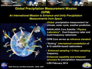
Global Water and Energy Cycle: Observation Strategy and Context GPM is flagship mission for NASA’s Global Water and Energy Cycle (GWEC) research and applications & key measuring element in Weather Science Focus Area
/Constellations Precipitation regimes
GPM science objectives • Precipitation measurement technology: advancing precipitation measurement capability from space • through combined use of active and passive remote-sensing techniques to calibrate dedicated & operational PMW sensors to achieve global coverage • Water/energy cycle variability: advancing understanding of global water/energy cycle and fresh water availability • through better measurement of the space-time variability of global precipitation • Weather prediction: improving NWP skills • through more accurate and frequentmeasurement of instantaneous rain rates • Hydrometeorological prediction: advancing flood-hazard and fresh-water-resource prediction capabilities • through improvedtemporalsampling and spatialcoverage • Climate prediction: improving climate prediction capability - through better understanding of precipitation microphysics, surface water fluxes, soil moisture storage, and latent heating
Accomplishing science objectives will directly feed into applications. GPM applications & outreach • Applications - Making GPM data products and resources accessible to users and stakeholders beyond the traditional precipitation science community - by establishing broader and more effective use of space-based precipitation data products in decision-support of a wide variety of societal applications • Freshwater Utilization and Resource Management • Natural Hazard Monitoring/Prediction (Flood Warnings, Hurricane and Cyclone Observation, Winter Weather Events) • Operational Weather Forecasting • Climate Change Assessment • Agriculture • Transportation • Policy and Planning • Outreach- Making immediate precipitation data products available to: • Students, teachers, and researchers in educational institutions via direct network access to GPM data products • Commercial and public television enterprises via near-real time graphic rain imagery • Any government, industrial, and academic data user agencies as well as private homes
OBJECTIVES • Understand horizontal & vertical structure of rainfall, its macro- & micro-physical nature, & its associated latent heating • Train & calibrate retrieval algorithms for constellation radiometers • OBJECTIVES • Provide sufficient global sampling to significantly reduce uncertainties in short-term rainfall accumulations • Extend scientific and societal applications GPM Reference Concept Constellation Core • Core Satellite • TRMM-like spacecraft (NASA) • H2-A rocket launch (JAXA) • Non-sun-synchronous orbit • ~ 65° inclination • ~407 km altitude • Dual frequency radar (JAXA) • Ku-Ka Bands (13.6-35 GHz) • ~ 4 km horizontal resolution • ~250 m vertical resolution • Multifrequency radiometer (NASA) (Conically-Scanning) • 10.65, 18.7, 23.8, 36.5, 89.0 GHz • 166, 183.3±~3, 183.3±7 or 9 GHz • Constellation Satellites • Pre-existing operational-experimental & dedicated satellites with PMW radiometers • Revisit time • 3-hour goal at ~90% of time • Sun-synch & non-sun- synch orbits • 600-900 km altitudes • Ground Validation Sites • Ground truth and calibration • Cooperative international partners High Frequencies Approved Sept. 2005 • Precipitation Processing System • Global precipitation products from diverse sensors and sources • Cooperative international partnerships
Error Std Dev in Rain Retrieval as Function of Rain Rate Simulated retrievals based on synthetic noises added to Hurricane Bonnie observations and an assumed drop size distribution TRMM Percent GPM ~1.5 mm hr-1 Courtesy of Z. Haddad ~12.5 mm hr-1 Rain Rate (mm/h) GPM Dual Precipitation Radar (DPR) • Increased sensitivity for light rain and snow detection –Addition of Ka band (35.5 GHz) to Ku band (13.6 GHz) improves the detection threshold from 0.5 to 0.17 mm/h, significantly improving measurements of rain occurrences in light rain and snow events • Better overall measurement accuracy -replacing the surface reference technique for path-integrated-attenuation correction with dual-frequency methods • More detailed microphysical information –detection of drop size distribution and identification of liquid, frozen, and mixed phase precipitation, leading to an improved cloud database for rain & snow retrievals for both the Core and constellation radiometers
GPM Microwave Imager (GMI) Ball Aerospace and Technology Corporation (BATC) design: 1.2 m GMI Key Parameters Mass:~100 kg Power:~90 W Data Rate:~25 kbps Antenna Size:~1.2 m Diameter Channel Set: 10.65 GHz, H & V Pol 18.7 GHz, H & V Pol 23.8 GHz, V Pol 36.5 GHz, H & V Pol 89.0 GHz, H & V Pol 166 GHz, H & V Pol, 183±~3 GHz, V (or H) Pol 183±~7 (or 9) GHz, V (or H) 2.4 m 1.0 m
GMI Instantaneous Field-of-Views TRMM / TMI at 350 km GPM / GMI at 407 km
Microphysical Meas. PDPR Microphysical Meas. & Ancillary PDPR Size of Uncertainty PGM Data GV goal is to provide ground observations for direct satellite product assessment and for algorithm/application improvements PGM PPMW Applications context PPMW GPM Validation Concept GPM validation goes beyond direct comparisons of surface precipitation rates between ground and satellite measurements
US GV strategy & Plan • Surface precipitation statistical validation sites for direct assessment of GPM satellite data products: • Co-located with existing or upgraded national network (NEXRAD etc.) and dense gauge networks • Precipitation process sites for improving understanding of precipitation physics, modeling, and satellite retrieval algorithms: • Continental tropical, mid- and high-latitude sites (including orographic/coastal sites and targeted sites for resolving discrepancies between satellite algorithms) • May include aircraft measurements and mobile instrument assets • Integrated hydrological sites for improving hydrological applications: • Co-located with existing watersheds maintained by other US agencies and international research programs These sites can be designed to overlap. US GPM Ground Measurement Advisory Panel (Chair: Chris Kummerow) recommends:
Weighting Functions 183.3±1 GHz HEIGHT (km) 183.3±3 GHz 183.3±7 GHz 150 GHz NOAA NEXRAD Data AMSU-B 89 GHz AMSU-B 183.3 ± 7 GHz Snow Retrieval 89 GHz SENSITIVITY g m3 4 in/h Feasibility demonstration of snowfall retrieval using HF channels Radar reflectivity composite of the March 5-6, 2001 New England blizzard (75 cm of snow fell on Burlington, VT) Surface effects evident over the Great Lakes, the St. Lawrence River, and along the Atlantic coast. Cannot distinguish surface from cloud effects. Surface effects screened by water vapor. Snowfall appears over New England as low brightness temperatures G. Skofronick-Jackson et al. (GSFC) TGARS 2004 Science value of HF channels on GMI • Measurement of frozen precipitation • Measurement of light rain • Improved PMW retrieval algorithms over land • Improved precipitation measurements in mid- and high-latitudes in cold seasons • HF channels on GPM Core enabling the testing and evaluation of constellation PMW algorithms using the DPR
Neural Nets/Polar Neural Networks Falling Snow Retrieval Algorithms Physically Based March 2001 March 2001 5.5mm/hr (Melted) Snow Detection MIT Chen and Staelin Trans Geosci Remote Sens 2003 NASA Goddard/U. Wash. Kim, 2004 Thesis ocean MIT, Staelin 25 January 2004 Algorithm development & improvement for GMI core and constellation satellites NOAA Kongoli, et al Geophys Res. Letters 2003 & Ferraro et al TGARS 2005
Expected GPM Constellation TRMM Reference TRMM + 2 DMSP SSM/I’s GPM Core + 3 NPOESS’s + GCOM-W + EGPM + Megha-Tropiques + NASA1 (optimized) Observations Per Day GPM + 3 AMSU GPM Base Configuration GPM Core + 3 NPOESS’s + GCOM-W + EGPM + NASA1 + Megha-Tropiques + 3 NOAA AMSU’s GPM Core + DMSP F18 + DMSP F19 + NPP + NPOESS1 + NASA1 (optimized) Temporal Sampling Risk Mitigation using AMSU Satellites
Conclusions Challenges • Pathway from HF sounders to HF imager products • Quantitative assessment of different products over land and oceans. • Evaluation of sounder retrieval methodologies and error estimates • Development of improved retrieval algorithms, especially over land • Algorithm development • Assessment of precipitating snowfall and light rain retrieval methodologies • Development and enhancement of reliable algorithms appropriate to DPR, GMI, and DPR+GMI observations • Validation • Appraisal of GV and in situ requirements for snow and light rain • Statistical, process, and hydrological needs The GPM Core satellite provides an unprecedented opportunity to measure falling snow and light rain to calibrate and improve PMW precipitation algorithms
Backup slides • Backup slides
Light Rain From TRMM/GPM workshop, October 2003
Frozen Particle Variability • Surface Variability CPI in situ images, Andy Heymsfield Challenges Non-Linear and Under-Constrained Relationshipsbetween physical characteristics of ice particles and microwave observations
Continuing Work Spherical versus Non-Spherical Assumptions Complex Atmospheric Snow Particle Shapes 150 GHz 183.3±7 GHz 183.3±3 GHz 89 GHz 183.3±1 GHz From Heymsfield et al. (2001) Courtesy of Min-Jeong Kim • For simplicity, spheres and dielectric mixing theories have been used. • Methodologies such as the Discrete Dipole Approximation (DDA) allow the computation of radiative properties for various idealized shapes of snow crystals. • These DDA calculations are in progress with results to be archived in a database open to scientific community for related remote sensing studies. (Contact Min-Jeong Kim at mjkim@neptune.gsfc.nasa.gov)
21Z 17 January 2003 MODIS Snow Cover (%) Observed SWE (mm) IMS Snow Cover Observations Observations Observations Model output Model output Model output Assimilated output Assimilated output Assimilated output Western Montana Control GLDAS SWE (mm) Assimilated SWE (mm) SWE Improvement (mm) Midwestern United States Central Atlantic MODIS Snow Cover Assimilation • MODIS snow cover fields used to update land surface models driven by the Global Land Data Assimilation System (GLDAS) • Models fill spatial and temporal gaps in data, provide continuity and quality control • Assimilated output agrees more closely with IMS snow cover fields and ground observations (figures) • Assimilated output contains more information (~hourly SWE) than MODIS (~daily snow cover) alone Locations of averaging regions and Cooperative Network snow observation sites Rodell, M., and P. R. Houser, Updating a land surface model with MODIS derived snow cover, J. Hydromet., 5 (6), 1064-1075, 2004.
WPAC CPAC EPAC Science drivers for precipitation measurement • Precipitation and latent heating drive the Earth’s weather/climate system through their coupling with the large-scale circulation to redistribute heat, momentum, and moisture. • Deep convection is the source of upper-troposphere water vapor – thus controlling the primary greenhouse gas in a radiatively responsive region. (Influence of precipitation is not confined to cloudy/rainy regions) • Cloud-scale microphysics and dynamics control the partition between rain and clouds, crucial for understanding climate sensitivity and feedback processes to improve climate prediction. • Accurate knowledge of precipitation is needed for monitoring freshwater availability and for closing the water/energy budget. • Frequency and intensity of extreme precipitation events may be a signal of natural or anthropogenic change. Key measurement for understanding and predicting freshwater availability, the water/energy cycle, and the weather/climate system
Traceability to NASA’s GWEC research plan • Variability: Is the water cycle accelerating in a warmer climate? • Response: How does precipitation variability influence surface hydrology, global transport, and weather/climate states? • Forcing: How do precipitation processes affect atmospheric moisture (the primary greenhouse gas), clouds, and cloud/radiation feedback? • Consequence: Are there more extreme weather events in a warmer climate? • Prediction: How do we use more accurate knowledge of global precipitation to improve weather, climate and hydrological modeling and prediction? GPM addresses science questions from NASA’s GWEC research themes