Download
1 / 26
260 likes | 435 Views
NASA Planning for GPM. Ramesh Kakar GPM Program Scientist Office of Earth Science NASA Headquarters May 16, 2001. How is the Earth Changing and What Are the Consequences for Life on Earth?. How is the global Earth system changing ? What are the primary forcings of the Earth system?

E N D
NASA Planning for GPM Ramesh Kakar GPM Program Scientist Office of Earth Science NASA Headquarters May 16, 2001
How is the Earth Changing and What Are the Consequences for Life on Earth? • How is the global Earth system changing? • What are the primary forcings of the Earth system? • How does the Earth system respond to natural and human-induced changes? • What are theconsequencesof changes in the Earth system for human civilization? • How well can we predict future changes in the Earth system?
How is the global Earth system changing? How are global precipitation, evaporation, and the cycling of water changing? How is the global ocean circulation varying on interannual, decadal, and longer time scales? How are global ecosystems changing? How is stratospheric ozone changing, as the abundance of ozone-destroying chemicals decreases and new substitutes increases? What changes are occurring in the mass of the Earth’s ice cover? What are the maotions of the Earth and the Earth’s interior, and what information can be inferred about Earth’s internal processes? What are the primary forcings of the Earth system? What trends in atmospheric constituents and solar radiation are driving global climate? What changes are occurring in global land cover and land use, and what are their causes? How is the Earth’s surface being transformed and how can such information be used to predict future changes? How does the Earth system respond to natural and human-induced changes? What are the effects of clouds and surface hydrologic processes on Earth’s climate? How do ecosystems respond to and affect global environmental change and the global carbon cycle? How can climate variations induce changes in the global ocean circulation? How do stratospheric trace constituents respond to change in climate and atmospheric composition? How is global sea level affected by climate change? What are the effects of regional pollution on the global atmosphere, and the effects of global chemical and climate changes on regional air quality? What are the consequences of change in the Earth system for human civilization? How are variations in local weather, precipitation and water resources related to global climate change? What are the consequences of land cover and land use change for the sustainability of ecosystems and economic productivity? What are the consequences of climate and sea level changes and increased human activities on coastal regions? How well can we predict future changes to the Earth system? How can weather forecast duration and reliability be improved by new space-based observations, data assimilation and modeling? How well can transient climate variations be understood and predicted? How well can long-term climate trends be assessed or predicted? How well can future atmospheric chemical impacts on ozone and climate be predicted? How well can cycling of carbon through the Earth system be modeled, and how reliable are future atmospheric concentrations of carbon dioxide and methane predicted by these models? How is the Earth changing and what are the consequences for life on Earth?
Relevant Science Plan Questions • How are global precipitation, evaporation, and the cycling of water changing? • How are variations in local weather, precipitation, and water resources related to global climate variation? • How can weather forecast duration and reliability be improved by new space-based observations, data assimilation and modeling?
Understanding the earth’s climate and how it responds to climate perturbations relies on what we know about how atmospheric moisture, clouds, latent heating, and the large-scale circulation vary with changing climate conditions. The physical process that links these key climate elements is precipitation…….
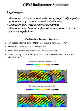
TRMM Sensors Precipitation radar (PR): 13.8 GHz 4.3 km footprint 0.25 km vertical res. 215 km swath Microwave radiometer (TMI): 10.7, 19.3, 21.3, 37.0 85.5 GHz (dual polarized except for 21.3 V-only) 10x7 km FOV at 37 GHz 760 km swath Visible/infrared radiometer (VIRS): 0.63, 1.61, 3.75, 10.8, and 12 :m at 2.2 km resolution Additional EOS instruments: CERES (Cloud & Earth Radiant Energy System) 720 km swath LIS (Lightning Imaging Sensor)
Tropical Rainfall Measuring Mission (TRMM) Ocean Rainfall Estimates With TRMM
Tropical Rainfall Measuring Mission • TRMM has reduced the uncertainty of climatological rainfall in tropics by over a factor of two, therefore establishing a standard for comparison with previous data sets and climatologies. • Extensive work is ongoing to understand the difference in the retrieved products from active and passive sensors. • TRMM has helped in refinement of SSM/I rainfall algorithms and thus has helped in the extension of data record by over ten years. • Ongoing study of changing rainfall patterns in concert with better known climate variables such as temperature or aerosol concentrations. • TRMM has shown the utility of precipitation information for the improvement of numerical weather forecasts and climate modeling. • There is a need to extend the rainfall observations to higher latitudes and improve the temporal resolution.
Tropical Rainfall Measuring Mission (TRMM) Three-Year TRMM Climatology January 1998 - December 2000
Tropical Rainfall Measuring Mission (TRMM) Three-Year Seasonal Climatology from TRMM N.H. Winter N.H. Spring N.H. Summer N.H. Fall
Sea Surface Temperature Measurements from TRMM High-resolution SST measurements through clouds from TMI data provided early detection of the 1998 La Nina and instability waves (Wentz, Science 1999) High-resolution SST measurements illustrated the deleterious effect of Hurricane Bonnie’s cold wake on the development of Hurricane Danielle
Tropical Rainfall Measuring Mission: TRMM Compelling New Looks at Hurricanes, Typhoons, and Cyclones TRMM has observed the inner structure of natural hazards like hurricanes Mitch, Bonnie, and Floyd. TRMM even provides measurement of sea surface temperature in cloudy tropical cyclone environments.
TRMM Impact on Mesoscale Simulation of Super Typhoon Paka SSM/I 85 GHz Brightness Temperature 13 DEC 1997 0911UTC PAKA (8.9N, 161.8E) Rain(mm/3hr), Sea-level Pressure & 850 hPa Wind 13 DEC 1997 0900UTC (IC: GEOS with TRMM + bogus Vortex based on 4-D VAR) • The Figures compare with the satellite picture of SSM/I brightness temperature at 85GHz Channel (Upper Left) the simulated Paka (33h forecasts) from Penn State/ NCAR MM5 model at 5-km horizontal resolution while the model initial conditions (at 0000UTC 12 DEC 1997) are generated from • GEOS analysis without TRMM data (TRMM derived rain rate and total precipitable water ) assimilation (Lower Left), • GEOS analysis with TRMM data assimilation (Lower Right) , and • MM5 adjoint-based four dimensional variational data assimilation, which incorporating GEOS analysis and TRMM data with mesoscale bogus vortex data into the mesoscale model (Upper Right). • Ask Zhao-Xia Pu (pu@gilbert.gsfc.nasa.gov) • for questions and additional information Rain(mm/3hr), Sea-level Pressure & 850 hPa Wind 13 DEC 1997 0900UTC (IC: GEOS without TRMM) Rain(mm/3hr), Sea-level Pressure & 850 hPa Wind 13 DEC 1997 0900UTC (IC: GEOS with TRMM) Authors: Zhao-Xia Pu and Wei-Kuo Tao NASA Goddard Space Flight Center/Mail Code 912
Forecasting Mozambique Floods Krishnamurti, The Florida State University
Near-term Challenges • Establish close agreement among TRMM passive and active retrieval of zonal means to establish calibration point for long-term analyses. • Finish Version 6 reprocessing of TRMM data with improved algorithms, while continuing to provide current products. • Combine global water vapor and precipitation analyses to determine if the variations (and possible trends) in cycling the water through the atmosphere are related to SST changes. • Determine fraction of regional variations in precipitation due to ENSO.
Near-term Challenges (contd.) • Successfully complete CAMEX4. • Demonstrate impact of assimilation CAMEX and TRMM data on forecasting track and intensity of tropical cyclones. • Determine tropical mean convective structure (fraction of convective vs. stratiform rainfall) for the first time using TRMM’s first three years of data. • Quantify improvement of numerical weather prediction related to assimilation of rainfall data. • Develop the necessary partnerships for GPM
Importance of precip.measurements • Availability of water governs the habitability of Earth • In an era of climatic uncertainty we should be able to detect, understand and react to early signs that rainfall patterns may be changing in concert with better understood climate variables • Transient nature of rainfall makes the detection of subtle changes difficult • Rainfall information over ~3 hours time scale is needed to improve nwp models, data assimilation models, hydrological models and flash flood forecasts
TRMM Limitations • TRMM cannot solve all problems associated with precipitation • TRMM does not provide measurements outside the tropics (35°N - 35°S) • TRMM sampling frequency at any point is limited to roughly 1 sample every 15 hrs for the radiometer and 1 sample every 50 hrs for the radar • TRMM rainfall uncertainties are dominated by sampling errors due to which it is impossible to detect subtle changes that may be associated with slowly changing climate
Future Challenges • Observe water in various states and the related fluxes well enough to close the atmospheric hydrologic cycle. • Develop and implement GPM to obtain the required precipitation observations. • Model the global hydrologic atmospheric cycle well enough to distinguish natural variability from long term trends associated with climate change.
Establishment of Partnerships • Interdisciplinary (e.g. Hydrology, Oceanography, Atm. Dynamics, Agriculture, Climatology etc.) • Interagency • International (very important) • Criterion for Selecting Science Team Members (ad hoc or NRA)
Operation of Science Team • Strong Interface between Science and Technology • Establishment/Endorsement of Level 1 Requirements • Establishment of Schedule for Science Activities • Writing of the Science Implementation Plan
New Observing System Questions • How are the rainfall and rainfall structure responding to changes in the Earth’s temperature and other climate variables and do we understand this response ? • How directly is the surface hydrology coupled to the rainfall/evaporation and do we understand the relationship well enough to be of predictive value? • What is the effect of rainfall over the oceans upon the ocean/atmosphere energy exchange and feedback mechanisms and can we understand this feedback?
OBJECTIVE: Understand the Horizontal and Vertical Structure of Rainfall and Its Microphysical Element. Provide Training for Constellation Radiometers. OBJECTIVE: Provide Enough Sampling to Reduce Uncertainty in Short-term Rainfall Accumulations. Extend Scientific and Societal Applications. GPM Reference Concept • Core Satellite • Dual Frequency Radar, NASDA • Multifrequency Radiometer, NASA • H2A Launch, NASDA • TRMM Like S/C, NASA • Non-Sun Synchronous Orbit • ~ 70° Inclination • ~400 - 500 km Altitude • ~ 4 km Horizontal Resolution • 250 m Vertical Resolution • Constellation Satellites • 8 Small Satellites with Microwave Radiometers • 1 NASA Provided? • 1 NASDA Provided? • 2 ESA Provided? • 4 Other Partners? • 3-Hour Revisit Time • Sun-Synchronous Polar orbit • ~ 600 km Altitude
Summary • Measurement of precipitation is important to understanding “How is the Earth Changing and What are the Consequences for Life on Earth?” • TRMM has played a tremendous role in the enhancement of precipitation studies • But TRMM has certain limitations • We need a precipitation measurement mission which is much broader in scope than TRMM • It is not too early to begin international partnerships needed to implement the next mission