Download
1 / 15
160 likes | 329 Views
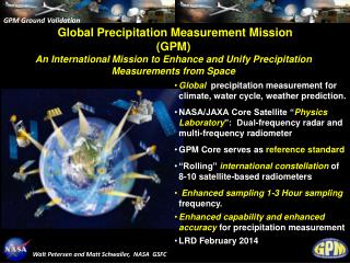
GPM Constellation Reconfiguration and Mission Status. Arthur Y. Hou NASA Goddard Space Flight Center arthur.y.hou@nasa.gov. IPWG 3rd Workshop, October 23-27, 2006 Melbourne, Australia. GPM is an international satellite mission to unify and advance global precipitation measurements.

E N D
GPM Constellation Reconfiguration and Mission Status Arthur Y. Hou NASA Goddard Space Flight Center arthur.y.hou@nasa.gov IPWG 3rd Workshop, October 23-27, 2006 Melbourne, Australia
GPM is an international satellite mission to unify and advance global precipitation measurements GPM advances over current capabilities: GMI KaPR KuPR • GPM Core Spacecraft carries a dual-frequency radar & a multi-frequency radiometer to provide measurements of 3-D precipitation structures and microphysical properties to serve as aprecipitation physics observatory for improved understanding of precipitation processes and retrieval algorithms. • GPM Core Spacecraft is in a 65o-inclined orbit to provide coincident measurements with partner satellites, enabling the Core radar/radiometer to serve as a reference standard to obtain uniformly calibrated global precipitation measurements from a heterogeneous constellation of dedicated and operational passive microwave radiometers.
GPM originally conceived as a satellite mission that provides precipitation measurements around the globe approximately every 3 hours by conically-scanning radiometers 3 Hour Coverage by GPM Core and 7 Constellation Radiometers comprising dedicated and operational satellites: GPM Core, F18, F19, GCOM-W, Megha-Tropiques, NASA-1, Partner-1, Partner-2
Recent progress in sensor capabilities and retrieval algorithms - notably • proven capability of AMSU-B high-frequency water-vapor channels • improved quality of AMSU-B precipitation retrievals • has enabled GPM to evolve during its formation phase • Milestones: • Approval of GMI high-frequency capabilities in 2005 • Reconfiguration of the baseline GPM constellation to include crossing-track microwave sounders over land • NASA constellation satellite in a low inclination orbit to improve near-realtime hurricane monitoring & prediction
Normalized RMS errors of TMI, AMSR-E, F13, F14, & F15 surface rain retrievals with respect to ground measurements over U.S., and corresponding errors for AMSU-B (15, 16, 17) and TRMM PR RMS errors due to temporal mismatches within 1h observation window for perfect retrievals Lin & Hou (2006) Surface Rain Retrievals from Passive Microwave Sensors Compared with TRMM PR Over U.S. 0.25o instantaneous retrievals within hourly windows against continuous surface radar & gauge measurements for JJA 2005 In GPM era most C-S imagers & X-T sounders will have HF channels Sounder retrievals with HF water vapor channels are closer to PR than C-S imagers without HF between 1-10 mm/h
0.25o instantaneous retrievals within hourly windows (Jan-Dec 2005) Over U.S. (South of 35N) Surface Rain Retrievals from Passive Microwave Sensors Over Land Over Tropical Land (35N-35S) TRMM PR RMS errors due to temporal mismatches within 1h observation window for perfect retrievals Lin & Hou (2006)
6 C-S Imagers Plus 4 Cross-track Sounders (Over land) (< 3h over 92% of globe) 6 Conically-Scanning Imagers (< 3h over 86% of globe) With addition of MetOp-B, NPP, NOAA-19, & NPOESS-C1 over land GPM Core, NASA-1(40o), F18, F19 GCOM-W, Megha-Tropiques Hour Average Revisit Times by Passive Microwave Sensors in GPM Era Lin & Hou (2006)
Passive Microwave Sensor (PMW) Characteristics in GPM Era V – Vertical Polarization H – Horizontal Polarization Constellation microwave sensor channel coverage Mean Spatial Resolution (km) Different center frequencies, viewing geometry, and spatial resolution must be reconciled
GPM provides a consistent framework to unify a heterogeneous constellation of PMW sensors (both C-S imagers and X-T sounders) Using DPR+GMI on GPM Core to calibrate coincident TB’s rainy and non-rainy pixels Coincident sensor TB calibrated to simulated TMI TB L1C homogenizes existing L1B for precipitation retrieval without replacing official L1B products An open community effort: http://mrain.atmos.colostate.edu/LEVEL1C/ Level 1B TB Bias at non-rainy pixels Intercalibrated Level 1C TB w.r.t. TMI Retrieved - Sensor TB (K) Courtesy C. Kummerow Sensor Channel (GHz) Sensor Channel (GHz) By making combined use of DPR & GMI on GPM Core Spacecraft to provide - a uniform calibration of brightness temperature measurements and - a common cloud/hydrometeor database for precipitation retrievals
Improve understanding of precipitation physics • Unify a heterogeneous constellation of passive microwave sensors to provide accurate and timely global precipitation measurements for research & applications NASA constellation in a low-inclination orbit • Improved near-real time hurricane monitoring and prediction GPM Core Spacecraft • Increased sensitivity for light rain and snow detection • Better overall measurement accuracy • Uniform calibration of brightness temperatures of Constellation sensors • Detailed microphysical information and a common cloud database for rain & snow retrievals from Core & Constellation sensors GPM Core NASA-40o GCOM-W Megha-Tropiques NOAA-19 NPP MetOp-B NPOESS-C1 GPM Mission:
GPM Ground Validation for Improving Satellite Simulators, Retrieval Algorithms, & Hydrological Applications • Statistical validation sitesfor direct assessment of GPM satellite surface precipitation products: • Co-located with existing or upgraded national network (NEXRAD etc.) and dense gauge networks to identify and resolve significant discrepancies between the national network and satellite estimates • Leveraging off national networks of partnership countries and international scientific collaboration for regional and global assessments • Precipitation process sitesfor improving understanding and modeling of precipitation physics in physical and radiance spaces for satellite retrieval algorithm refinements: • Continental tropical, mid- and high-latitude sites (including orographic/coastal sites and targeted sites for resolving discrepancies between satellite algorithms) • Oceanic tropical and mid-latitude sites • Aircraft measurements • Integrated hydrological sitesfor improving hydrological applications: • Co-located with existing watersheds maintained by other US agencies and international research programs to use hydrological basins as an integrated measure of the quality of precipitation products International GPM GV partnership opportunities
Joint CloudSat/CALIPSO/GPM Field Campaign GPM Participation in the Canadian CloudSat/Calipso Validation Program Winter 2006-2007 • GPM hardware contributions: • an Advanced Multi-frequency (Ka-Ku-W) radar (UMass) • a 2D video disdrometer (CSU) • GSFC Parsvels for measuringhydrometeor numbers, sizes (maximum width), type, and fall speeds 2. Collection of data sets for development of GPM snowfall detection and estimation algorithms • Develop models that convert microphysical properties (snow size, shape distributions, density, ice-air-water ratio) to radiative properties (asymmetry factor, absorption-scattering-backscatter coefficients) • Relate radiative properties to microwave radiances and radar reflectivities observed by GPM instruments • Combine satellite, aircraft and ground measurements for GPM GMI and DPR algorithm validation • Support Cloud-Resolving Model (CRM) microphysics validation in cold-region simulations
GPM Mission Status • NASA and JAXA have signed an agreement to jointly formulate the GPM mission with the following assumptions: • JAXA to provide a Dual-frequency Precipitation Radar (DPR) for the GPM “Core” spacecraft and launch services for the Core spacecraft • KuPR and KaPR engineering model under development & testing • NASA to provide two GPM Microwave Imager (GMI)’s, the Core spacecraft, a constellation spacecraft & associated launch services • GMI in development by Ball Aerospace Technology Corporation • Joint NASA and industry development of Core Spacecraft underway • Selection of a new NASA/Precipitation Missions Science Team (November 2006) • GPM Core spacecraft launch circa 2013 • Constellation partnership development • Partnerships in formulation: JAXA, NOAA, DoD • Partnerships under discussion: AEB (Brazil) • Future opportunities: ISRO(India)/CNES(France), ESA, EUMETSAT • GPM Planning Workshops • 6th GPM International Planning Meeting to be held 6-8 November 2005 in Annapolis, MD, USA. • 2nd GPM International Ground Validation Workshop held in September 2005 in Taipei, Taiwan. 3rd GV Workshop is under planning for 2007.
“The (NASA) Global Precipitation Measurement (GPM) mission should be launched without further delays.” • Earth Science and Applications from Space: Urgent Needs and Opportunities to Serve the Nation, National Academies Press, Washington, DC, 2005 Recent National Research Council Recommendations “NOAA takes over the operation of the GPM Core satellite from NASA five years after launch.” “Develop a GPM follow-on NOAA program... as U.S. components of a continuing and evolving international constellation of satellites within the WMO ... for satellite-based global precipitation measurements.” – Report of NRC/BASCCommittee on the Future of Precipitation Missions, September, 2006
The GPM Mission will unify and advance global precipitation measurements by providing • advanced microwave sensors (DPR & GMI): • a consistent framework for inter-satellite calibration • science teams for algorithm development, ground validation, and improved use of precipitation data in research & applications Summary The success of GPM will rely on the continued support and advocacy of the community such as IPWG!