Download
1 / 14
140 likes | 278 Views
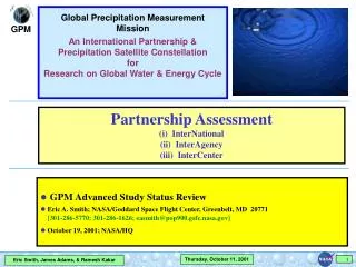
Global Precipitation Measurement Mission An International Partnership & Precipitation Satellite Constellation for Research on Global Water & Energy Cycle. Partnership Assessment (i) InterNational (ii) InterAgency (iii) InterCenter. GPM Advanced Study Status Review

E N D
Global Precipitation Measurement Mission An International Partnership & Precipitation Satellite Constellation for Research on Global Water & Energy Cycle Partnership Assessment (i) InterNational (ii) InterAgency (iii) InterCenter • GPM Advanced Study Status Review • Eric A. Smith; NASA/Goddard Space Flight Center, Greenbelt, MD 20771 [301-286-5770; 301-286-1626; easmith@pop900.gsfc.nasa.gov] • October 19, 2001; NASA/HQ
SSM/I Era TRMM Era EOS Era TRMM 1-day coverage GPM Era
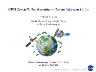
Summary of InterNational Partnership Progress on Constellation Development 1. ASI (Italy):Consideration of IGPM as joint mission opportunity within ASI-NASA Earth Science Mission Partnership deliberations -- not likely. 2. CSA (Canada):No progress yet because CSA-NASA Earth Science Mission Partnership deliberations not yet initiated. 3. CNES (France):Indication to Code Y that they wish to consider ISRO/CNES Megha Tropiques satellite as their contribution to GPM constellation; informal understanding with CNES Project Scientist (M. DeBois) that data sharing could be done through CNES. 4. EC (European Commission):Director of EC Earth Science Research Program (A. Ghazi) has agreed to support GPM-related research within EU. 5. ESA (Europe):Coordinated effort taking place between GSFC-GPM leads (Adams & Smith) and EGPM PIs (Mugnai & Testud) to submit Step 2 EGPM proposal to ESA's Earth Explorer Opportunity Missions Program (Step 1 proposal submitted Sept. 28, 2001). 6. ISRO (India):Letter from ISRO Director to Code Y that they wish to contribute Megha Tropiques satellite as member of GPM constellation. 7. NASDA (Japan):LOA underway for NASA-NASDA partnership on GPM Core Satellite and utilization of NASDA's GCOM-B1 satellite in GPM constellation. 8. NSMC (PR China):Direct inquiry to NSMC science staff in Beijing by representative of GPM Project Scientist indicates they wish to contribute FY-3 data stream to GPM under quid pro quo that would allow them access to GPM constellation data.
Strategy for Populating Constellation Reference NPOESS-1 (Lite) GPM Core (CMIS-C1) N-GPM1 b (ATMI/DPR/N-CMR) DMSP-F18 (N-PMR) (SSMIS) NPOESS-2 DMSP-F19 E-GPM TRMM (CMIS-C2) (E-PMR) Optimization and Compromise Co-Op Drone Partners Potential New Drones/Partners (SSMIS) DMSP-F16 AQUA DMSP-F20 DMSP-F16 ADEOS-II FY-3 (C-PMR) NPOESS-3 (SSMIS) (CMIS-C3) GCOM-B1 MEGHA TROPIQUES (MADRAS) (AMSR-FO) TBD
GPM Era Coverage with 3 InclinedGPM Core,DMSP-F18,DMSP-F19,GCOM-B1,Megha-Tropiques,& Three 600-km Drones @ 34∞,84∞,90∞ 3-hour Ground Trace
7-Day Worst Case Revisit Time 600-km Sun-Synchronous 600-km Inclined - 34∞, 84∞, 90∞ GPM Core, Four Co-ops, & Three 600-km Drones
Percentage of 3-Hour Intervals Sampled in 7-Day Period Precipitation Sampling Worldwide: Constant Area Pixels GPM Era EOS Era GPM Core, DMSP-F18 & -F19, GCOM-B1, Megha-Tropiques, & Three 600-km Drones @ 34∞, 84∞, 90∞ Inclination TRMM, DMSP-F13, -F14, & -F15, Aqua, & ADEOS-II
Potential GPM Validation Sites Canada England Germany NASA Land Spain Italy South Korea ARM/UOK Japan NASA KSC Taiwan France (Niger & Benin) India NASA Ocean Brazil Australia Regional Raingage Site Supersite Supersite & Regional Raingage Site
Summary of InterCenter Partnership Progress 1. JPL JPL has played major role in Advanced Study in analyzing technology issues, studying spacecraft design, examining at high-tech rain radar option, & understanding how CRL's Dual-frequency Precipitation Radar (DPR) instrument will improve retrievals. 2. GHCC @ MSFC GHCC @ MSFC has led one of five major science requirements working group segments, i.e.,Climate System Variability & Climate Diagnostics: Role of Precipitation, & has agreed to generate SSMIS & AMSR datastreams for Global Precipitation Data Processing Center at GSFC. They may also propose LIS instrument as auxiliary payload for core satellite.
Summary of InterAgency Partnership Progress 1. IPO IPO is prepared to partner at programmatic level -- MOU needs to be developed. 2. NCAR NCAR is prepared to partner at scientific level -- further negotiations are needed to define programmatic nature of partnership. 3. NOAA Fact finding meeting between GPM (Adams & Smith) & group of NOAA scientists from 7 divisions concerning NOAA's 10-year precipitation needs for research & operations is scheduled for late 2001. This partnership cannot be pursued until agreement between upper level management in NASA & NOAA is in place. 4. NRL-Monterey NRL is prepared to partner at scientific level -- further negotiations are needed to define programmatic nature of partnership.
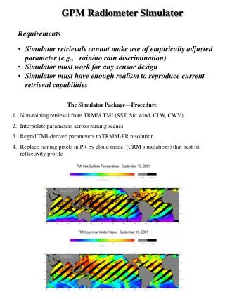
10 5 0 First PR-2 Ku-band Rain Radar Observations: Tropical Storm Chantal during CAMEX-4 Altitude (km) 20:22 20:18 20:18 20:18 20:06 20:10 20:14 20:22 20:06 20:10 20:14 20:22 20:06 20:10 20:14 Flight Time (UTC) Flight Time (UTC) Flight Time (UTC) Vertical rainfall profiles of Tropical Storm Chantal acquired by PR-2 radar on NASA DC-8 aircraft during 2nd flight of Fourth Convection & Moisture Experiment (CAMEX-4) on August 20, 2001. These results are at Ku-band (14 GHz) frequency. Left panel shows nadir cross-section of co-polarized (HH) reflectivity profiles along flight path. Detailed structures of both melting layer (at left) and intense convective region (at right) are apparent. Ocean surface returns are shown as white line. Region below white line corresponds to 1st mirror image (double bounce) of radar returns from rain above surface. Middle panel shows corresponding profile of Linear Depolarization Ratio (LDR), i.e., log-ratio of cross- to co-polarized reflectivities (HV/HH). LDR accentuates ice particles at melting layer. Right panel shows vertical Doppler velocity. In left portion of image, fall speeds sharply change at melting layer as ice particles fall slowly & then melt, increasing to 5-10 ms-1 at lower altitudes. In right portion of image, much larger velocities are associated with both concentrated downdrafts & updrafts in convective region.
First PR-2 Dual-f Rain Radar Observations: Predominantly Convective Rainfall during CAMEX-4 First simultaneous dual frequency Ku-Ka band (14-35 GHz) vertical rain profiles acquired by PR-2 radar on NASA DC-8 aircraft during TRMM’s KAMP (Key Area Microphysics Project) experiment. This is leg from validation flight flown during Fourth Convection & Moisture Experiment (CAMEX-4) conducted on September 3, 2001. Panels at top- & bottom-left show nadir cross-sections of co-polarized (HH) radar reflectivity profiles along flight path at 14 & 35 GHz, respectively. Comparison between cross-sections highlights different sensitivities at two frequencies to rainrate. It is evident that 35 GHz channel is better able to detect lower rainrates (e.g., regions around 1, 1.4, & 2 min) as well as providing more dynamic range at rain layer tops (e.g., regions around 1 & 2.1 min). It is also evident that 35 GHz undergoes stronger attenuation at higher rainrates (e.g., regions around 0.25 & 2.5 min). Notably it is regions where differential reflectivity is most significant that use of both frequencies most improves rainrate estimates (typically intermediate values). Corresponding profiles of Linear Depolarization Ratio (LDR), i.e., log-ratio of cross- to co-polarized reflectivities (HV/HH), are shown in top-right & bottom-right panels. LDR returns are stronger at 35 GHz, partly due to enhanced multiple scattering effects at higher frequency, and partly due to greater sensitivity to non-sphericity of smaller rain and ice hydrometeors.