Mapping the Southwest: Bringing Historic Maps Online
Explore the Mapping the Southwest project, digitizing 5,000 rare maps from 1493 to present. Learn about the high-quality scanning equipment used and the impact on access and preservation. Discover challenges and lessons learned in the process.

Mapping the Southwest: Bringing Historic Maps Online
E N D
Presentation Transcript
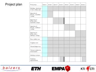
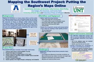
Mapping the Southwest Project: Putting the Region’s Maps Online • Daniel Gelaw Alemneh, Jerrell Jones, Cathy Hartman, Mark Phillips • Ann Hodges, Ben Huseman, and Carolyn KadriUniversity of North Texas andUniversity of Texas at Arlington Libraries Background Workflow and Equipment The MSW Collection as of May 2013 http://texashistory.unt.edu/explore/collections/UTAM/browse/ • Mapping the Southwest is a 3-year project (2010 to 2013) funded by a National Endowment for the Humanities (NEH) We the People grant. The University of North Texas (UNT) Libraries partnered with the University of Texas at Arlington (UTA) Library’s Special Collections to digitize 5,000 historically-significant and rare maps. The collection includes maps dating from 1493 to the present and features noted cartographers. While containing maps of all parts of the world, the collection particularly emphasizes the region of the Gulf Coast and the Greater Southwest. • Better Light Scanning System • Better Light Super 8K-2 scanning back • 4 x 5 camera with an array of changeable lenses • Heavy-duty studio stand with versatile head • High Intensity Discharge (HID) lights • Vacuum easel • Ensure the long-term access and preservation of the maps by creating a high quality product • Tiff (uncompressed) • RGB color (24-bit) Impact and Lessons Learned Better Light Super 8K-2 scanning back • The UNT-UTA collaborative project was able to meet the challenges and share the rich cartography collections of the region widely: • All of the digitized maps are available online for free public access • 80,000+ uses from all over the world • Besides showcasing the cartography of the region, it promotes best practices: • Advance the capacity of academic libraries to reliably curate and provide seamless access to such large-format items Preparation of Physical Map for Scanning Project Plan Challenges • The overall work plan consists of six major work areas. • Digitization of large-format items presents many challenges: • Inter-institutional differences in priorities, workflows, etc. • Map handling/scanning: folded, oversized, and fragile maps • Equipment maintenance and software updates • Metadata and related workflow issues Catalog maps without existing MARC records. Prepare the maps for transport. Capture and process digital images of the maps. Create software to automate import of MARC data to populate the metadata template. Create or enhance metadata. Assess quality of the digital images, cataloging, and metadata. Project Contacts Cathy Hartman, PI: Cathy.Hartman@unt.edu Mark Phillips, Technical & workflow management: Mark.Phillips@unt.edu Daniel Alemneh, Project manager: Daniel.Alemneh@unt.edu Ann Hodges, Project Coordinator at UTA: ann.hodges@uta.edu Ben Huseman, Maps handling and related activities: huseman@uta.edu Carolyn Kadri, Cataloging and metadata quality: kadri@uta.edu