Download
1 / 8
80 likes | 185 Views
The Long-Range Identification and Tracking (LRIT) system is crucial for maritime safety, providing a world-wide communication platform that collects positioning data from vessels every six hours. With over 10,000 EU-flagged ships and participation from 35 EU/EFTA states, this system aids in safety, security, and environmental protection. It enables coastal states to monitor vessels within 1,000 nautical miles, supporting search and rescue operations and combating piracy. Operational since June 2009, LRIT represents a significant advancement in maritime tracking and response capabilities.

E N D
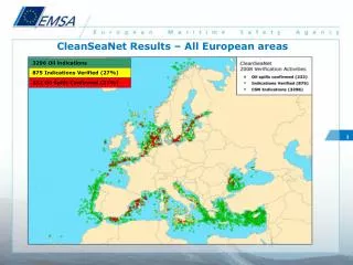
3296 Oil indications 875 Indications Verified (27%) 232 Oil Spills Confirmed (27%) CleanSeaNet Results – All European areas 1
2. LRIT (Long Range Identification and Tracking) International, world-wide system of Communication Satellite networks receiving positioning information from ships. Ships link to a LRIT Data Centre, where every 6 hours messages are collected. Legal basis • IMO SOLAS Chapter V Reg 19-1 • Council Resolution of 2 Oct 07 and 9 Dec 08 • Directive 2009/17/EC 2
LRIT: for safety, security, SAR and environmental protection • Flag state • Receives 4 messages per day on the position of its vessels worldwide, higher frequency possible • Coastal state • Receives the position of all vessels within 1.000 nautical miles of its coast (through its LRIT Data Centre) • Port state • request the position of a vessel (or vessels) coming to its port(s) based on Notice of Arrival • SAR • request LRIT information in relation to the SAR 3
Significance of EU LRIT Data CentreOperational since June 2009 • EU Flagged ships • Approximately 10 000 vessels • Overseas territories • Approximately 1000 vessels Status Sept. 2009: 7025 ships in EU DB 4 Status Sept. 2009: 7025 ships in EU DB EU LRIT DC to cover about 25% of world’s fleet 35 EU/EFTA states, Overseas Territories and third countries participating
EU LRIT DC position information 5 Malta flagged ships around the world: positions at 20091013 – 1140 UTC
Example of LRIT tracking outside EU (Norwegian flagged ships) 6
EU LRIT DC: “anti-piracy tool” 7 Pilot Project started in September 2009 EUNAVFOR Monitoring Area
“Anti-Piracy tool” Mandatory position reports (6 hours) • Alert message (in and out) • Automatic increase of the periodic rate of transmitting LRIT reports to the Flag State and EUNAVFOR • 12 EU Member States participating(status mid-Oct) 8 Increased rate (1 hour)