Download
1 / 21
210 likes | 312 Views
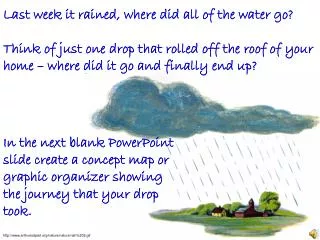
Last week it rained, where did all of the water go? Think of just one drop that rolled off the roof of your home – where did it go and finally end up?. In the next blank PowerPoint slide create a concept map or graphic organizer showing the journey that your drop took.

E N D
Last week it rained, where did all of the water go? Think of just one drop that rolled off the roof of your home – where did it go and finally end up? In the next blank PowerPoint slide create a concept map or graphic organizer showing the journey that your drop took. http://www.arthursclipart.org/nature/nature/rain%202.gif
To help remind you: Some examples of graphic organizers. Click to print out FREE - graphic organizershttp://peak-ict.wikispaces.com/Graphic+Organisers http://www.sthelena.vic.edu.au/libraryonline/Mindmaps.htm#__EXAMPLES_OF_MIND_MAPS http://www.learnnc.org/lp/editions/writing-process/5809 http://blogs.foxtoledo.com/2009/03/ http://www.free-graphics.com/clipart/Weather/rain_drop.shtml
In this space, describe what a watershed is… __________________________________________________________________________________________________________________________________________________________________________________________________________________________________________________ http://www.awag.org/Education/Watershed_diagram.jpg
In this space, describe what a watershed is… A watershed is the area of land where all of the water that is under it or drains off of it goes into the same place. http://water.epa.gov/type/watersheds/whatis.cfm http://www.awag.org/Education/Watershed_diagram.jpg
Can you name the watershed for your township? Do you know where your precipitation goes? ___________________________________________________
The Wissahickon Creek Watershed encompasses an area of 64 square miles, which includes 15 municipalities in Montgomery County and the City of Philadelphia. Wissahickon Creek begins in Montgomery Township and flows for approximately 27 miles where it meets with the Schuylkill River at the end of Lincoln Drive. The watershed includes extensive park and recreational areas as well as a designated use for trout stock fisheries. The Wissahickon Creek is also a source of drinking water for the City of Philadelphia Municipalities within this watershed drainage include: Upper Dublin Township, Lower Gwynedd Township, Whitemarsh Township, Springfield Township, Whitpain Township, Upper Gwynedd Township, Abington Township, Montgomery Township, Ambler Borough, Lansdale Borough, North Wales Borough, Cheltenham Township, Horsham Township, Worcester Township, Upper Moreland Township, and the City of Philadelphia. Your precipitation goes into the: Wissahickon Watershed http://www.phillyriverinfo.org/Watersheds/Wissahickon.aspx http://upload.wikimedia.org/wikipedia/commons/5/5e/Map_of_Montgomery_County_Pennsylvania_School_Districts.png
Think of your suburban neighborhood, what makes it different from a rural farm area? And from urban neighborhoods? http://roadwaytocollege.com/go/page.pl/000000A/http/bensguide.gpo.gov/k-2/neighborhood/index.html
What effect does this have on the precipitation that falls in various neighborhoods? Urban Runoff Modeling Description: You will build a simple watershed model that demonstrates how the volume of stormwater runoff changes as rural neighborhoods become urban communities. The paint roller tray is a watershed; the bare tray is an urban watershed with 100% impervious surfaces, the tray with felt cover is a natural vegetated watershed with 0% impervious surfaces. http://watermonitoring.uwex.edu/pdf/level1/Pubsurbanrunoffmodel.pdf
First - Using your spray bottle, rain on the natural vegetation watershed. Place the felt over the sloped area of the paint roller tray. Spray the felt with even sprays while counting the number of sprays. Record the number of sprays it took to get one drop of runoff from the “natural vegetated watershed” into the “stream” http://watermonitoring.uwex.edu/pdf/level1/Pubsurbanrunoffmodel.pdf
Next - remove the felt and dry out paint roller pan Say that the natural vegetated watershed has been dramatically converted into an urban watershed with 100% impervious surface. Make bulldozer noises if you like as the felt is removed and the urban scene is revealed. NOTE - This is a dramatic illustration; going directly from a fully naturally vegetated watershed to a fully urbanized one.
Finally - rain on the urban watershed. Spray the sloping area of the bare roller pan with even sprays. Count the sprays it takes to get one drop of runoff from the “urban watershed” into the “stream”. Continue spraying until the spray count is the same as what produced a single drop of runoff in the “naturally vegetated” watershed. How much more water is in the stream? http://watermonitoring.uwex.edu/pdf/level1/Pubsurbanrunoffmodel.pdf
This is how urban and rural runoff looks in a hydrograph http://watermonitoring.uwex.edu/pdf/level1/pubsurbanrunoffmodel.pdf
Follow the Wissahickon where does it end? ____________________________________________ http://commons.wikimedia.org/wiki/File:Schuylkillmap.png
Follow the Wissahickon where does it end? Schukill River http://commons.wikimedia.org/wiki/File:Schuylkillmap.png
Now Follow the Schukill River where does it end? ____________________________________________ http://commons.wikimedia.org/wiki/File:Schuylkillmap.png
Now, follow the Delaware River, where does it end? _________________________ http://waterresearch.blogspot.com/2007/07/delaware-river-ice-jam-flooding.html
Now, follow the Delaware River, where does it end? Delaware Bay http://waterresearch.blogspot.com/2007/07/delaware-river-ice-jam-flooding.html
Where does the Delaware Bay lead to? _________________________ http://waterresearch.blogspot.com/2007/07/delaware-river-ice-jam-flooding.html
Where does the Delaware Bay lead to? Atlantic Ocean http://waterresearch.blogspot.com/2007/07/delaware-river-ice-jam-flooding.html