Download
1 / 29
290 likes | 453 Views
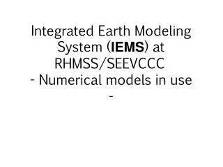
Integrated Earth Modeling System ( IEMS ) at RHMSS /SEEVCCC - Numerical models in use - . SEEVCCC Integrated Earth Modeling System . NCEP NMMB atmospheric model ● global/regional/local ● hydrostatic/nonhydrostatic. Aerosol ↔ radiation. Aerosol ↔ cloud. Ocean model. DREAM Dust

E N D
Integrated Earth Modeling System (IEMS) atRHMSS/SEEVCCC- Numerical models in use -
SEEVCCC Integrated Earth Modeling System NCEP NMMB atmospheric model ● global/regional/local ● hydrostatic/nonhydrostatic Aerosol ↔ radiation Aerosol ↔ cloud Ocean model • DREAM Dust • Sea salt • Carbon • Pollution HYPROM Hydrology model Fe and P nutrients
NMMB model characteristics • Grid point model on Arakawa B grid • Sigma vertical p-hybrid coordinate, Lorenz vertical grid • Easily can be run as global or regional model • Novel implementation of the nonhydrostatic • Dynamical core with horizontal differencing that preserves many important properties of differential operators and conserves a variety of basic and derived quantities including, energy and enstrophy • Two land surface packages: NOAH and LISS • Two radiation schemes: RRTM and GFDL • Two microphysics: Ferrier and Zhao • Bets-Miller-Janjic convection • Melloer-Yamada-Janjic turbulence and surface layer For more information please check references: (Janjic, 2005; Janjic and Black, 2007; Janjic et al., 2001, 2011,2013)
Hypothetical NMMB Simultaneous Run Global [with Igor & Julia] and NAM [with CONUS nest] Courtesy of DiMego et al. 12 km NAM NMMB 9 km Julia NMMB 4 km NAM-nest NMMB 9 km Igor NMMB 12 km NAM NMMB 27 km Global NMMB 27 km Global NMMB
Introduction: downscaling set-up • Regional model: NMMB (NonhydrostaticMultiscale Model) • Horizontal resolution: 14km and 8km experiment • Initial and lateral boundary data: ERA40 reanalysis • Horizontal resolution: 250km • Downscaled period: 1971-2000 • Data used for verification • Observations from RHMSS station network • ERA40 surface fields, 250km resolution • EOBS, gridded climatology for EU, 25km resolution • CARPATCLIM, gridded climatology for Carpathian region, 10km resolution
Introduction: downscaling set-up NMMB domains: green – low resolution purple – high resolution
Temperature annual mean bias (daily temperatures) BIAS (°C) ERA40 EOBS NMMB 14km NMMB 8km
Precipitation annual mean bias (daily precipitation) BIAS (%) ERA40 EOBS NMMB 14km NMMB 8km
Precipitation annual cycle (daily precipitation) Beograd Vrsac o - Oservationas o-NMMB-8 o - NMMB-14 Selected stations: o ERA40; oNMMB8; o OBS
Daily precipitation - seasonal distributions (winter) (spring) (summer) (autumn)
Monthly precipitation - seasonal distributions (winter) (spring) (summer) (autumn)
Non-hydrostatic MultiscaleModel – NMMB (NCEP/ZavisaJanjic)Global operational forecast at RHMSS/SEEVCCC NMMB Global domain Horizontal res 0.48 x 0.36 deg Vertical res 64 levels 10 days forecast Initial conditions from GFS/ECMWF
Republic Hydrometeorological Service Of Serbia Hydrology component of IEMS- HYPROM model - • HYPROM model is developed to simulate overland watershed processes. It is designed to be easily applied to different watersheds and across a broad range of spatial scales, from local to regional and global. HYPROM can be useful tool for predicting short-term flood events, as well as for water balance assessments and climate studies (Nickovic et al., 2010). • HYPROM consists of two sub-models: two-dimensional representation of overland flow and one-dimensional river routing component that collects the excess water in a drainage basin. It uses real topography, river routing and soil texture data from USGS datasets. • HYPROM model is driven with the advanced non-hydrostatic NCEP/NMM-E atmospheric model (Janjic et al., 2001; Janjic, 2003), which is widely used to produce operational weather forecasts. It simulates precipitation and calculate surface and base runoff from rainfall and snowmelt using the NMM-E land surface scheme.
HYdrology PROgnostic Model HYPROM model: • Dynamical treatment of overland flow • Suitable for long term and flash floods simulations • Applicable to small and large watersheds • Computationally efficient
dynamical treatment of overland flow (NO kinematic approximation!) numerically stable implicit time scheme for the friction term new numerical technique for preventing grid decoupling noise suitable for long term and flash flood simulations h - points u,v -points computationally efficient A-B-C-D-E-F river points Governing equations }One-D River routing Ničković S. et al, 2010: HYPROM hydrology surface-runoff prognostic model, Water Resource Research
Hydrology Prediction Model HYPROM Case study: the Moraca river watershed: 3200 km2
acc. rainfall 26 Oct – 6 Nov1990 Case study: the Savinja river, flash flood event watershed: 1850 km2 T and V at 850 hPa, 1Nov1990 model .vs. observations accumulated precipitation (mm) river discharge (m^3/s) forecast hour (h) forecast hour (h)
Republic Hydrometeorological Service of Serbia Aerosol component of IEMSDREAM dust model DREAM model is developed as an add-on component of the atmospheric model and is designed to simulate and/or predict the atmospheric cycle of mineral dust aerosol. It solves the Euler-type partial differential nonlinear equation for dust mass continuity. Dust concentration is one of the governing prognostic equations in an atmospheric numerical prediction model (Janjic, 1990, 1994, and references thereinafter). DREAM simulates all major processes of the atmospheric dust cycle (Nickovic et al., 2001). During the model integration, calculation of the surface dust emission fluxes is made over the model cells declared as deserts. A viscous sub-layer parameterization regulates the amount of dust mass emission for a range of near-surface turbulent regimes. Once injected into the air, dust aerosol is driven by the atmospheric model variables: by turbulence in the early stage of the process when dust is lifted from the ground to the upper levels; by winds in the later phases of the process when dust travels away from the sources; and finally, by thermodynamic processes and rainfall of the atmospheric model and land cover features which provide wet and dry deposition of dust over the Earth surface.
Impacts of Sand and Dust • Human Health (asthma, infections, meningitis in Africa, valley fever in the USA) • Marine productivity • Aviation • Agriculture • Ground transportation
Impact on radiation: Cooling surface atmosphere by ~5○C Perez et al, 2006
Comparison of DREAM Model Aerosol Mass with Ice Nuclei Measurements at Kleinerfeldberg Frankfurt 20 May – 3 June 2008 Bingemer, Ničković, Barrie, 2009
Significance of mineral composition in desert soils • Fe and P embedded in dust ocean nutrients • Cloud ice nucleation sensitive to mineral composition • Hypothesis: Fe as an enhancement factor in meningitis outbreaks (Thompson, 2008)
Minerals in erodible soils • mineral composition of dust aerosols is important for: • human health, ocean productivity, cloud ice nucleation, atmospheric radiation • we develop 1km resolution global data set of mineral fractions in arid soils: • silicates (quartz, feldspar, illite, kaolinite, smectite), carbonates (calcite), qypsum, • iron oxides (hematite) • work on implementation of mineral transport in atmospheric models • mineral data set will be used as mask of mineral sources for uptake in atmospheric models with included transport on mineral particles Example: quartz (mineral with largest percentage) content in erodible soils in silt and clay part
7:45 PM Phoenix as the dust storm neared Phoenix (Arizona) Haboob, 5 July 2005 • Dust modeling – NMME DREAM (operational model) • Improved by assimilation of the dust analysis • CCOR ~0.6 – quality forecast • Among leading models by verification scores in WMO SDS-WAS project • In high resolution case runs (<5km) for severe dust storms it shows potential for application in warning systems (work in progress). W.A.Sprigg, S. Ničković, G. Pejanović, J. Galgiani, A. Vuković
Successful simulation of the Phoenix Haboob: NMME-DREAM (collaboration: SEEVCCC and Chapman University dust modeling group) DUST SIMULATION: 3.5-km model 10m WIND MAGNITUDE Phoenix Phoenix W.A.Sprigg, S. Nickovic, G. Pejanovic, A. Vukovic
Operational dust forecast: DREAM ● DREAM8: Dust Regional Atmospheric Model with 8 categories for particle sizes • model runs: 12UTC start ; +72h forecast • model resolution: 1/3 degrees (~35km) • models: DREAM8 and DREAM8-assim (assimilation using ECMWF dust aerosol analysis) presented: model run from June 11th 2010 12UTC DREAM8 DREAM8 – assim