Classroom Mapping and Geography Activities Overview
In this lesson plan, students will create a detailed map of their classroom, including key locations such as student desks, podium, teacher desk, and chalkboard. Each student will mark their seating position. Additionally, students will explore absolute and relative locations of major European cities including London, Madrid, Moscow, Oslo, and Athens by using specified textbook pages. The lesson incorporates a group activity with station rotations where students will follow specific instructions. Finally, students will label the 50 states and capitals on a map for an upcoming test.

Classroom Mapping and Geography Activities Overview
E N D
Presentation Transcript
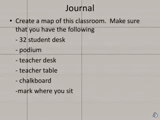
Journal • Create a map of this classroom. Make sure that you have the following - 32 student desk - podium - teacher desk - teacher table - chalkboard -mark where you sit
Practice (grab a textbook for you and a friend) • Put these in your notes- • Turn to page RA20-21 • What are the absolute and relative locations of the following European cities? • London, England • Madrid, Spain • Moscow, Russia • Oslo, Norway • Athens, Greece
Station Activity • You will be put into groups and you will start with a station. Please read and do what the paper says as a group. • When I say “Yellow Potato Salad” please rotate to the next station on your right.
MAP • Label the 50 states and capitols • You will be tested over the map • 25 points- ½ point per state • Extra credit- ¼ point per capitol • Test Date-August 31 • pp.RA- 18-19