Download
1 / 22
220 likes | 400 Views
Understanding Downscaled Climate Scenarios over Idaho. Brandon Moore and Von P. Walden University of Idaho (with lots of input from Eric Salathe, UW CIG). Outline. Purpose for downscaling climate for Idaho Description of the downscaling method

E N D
Understanding Downscaled Climate Scenarios over Idaho Brandon Moore and Von P. Walden University of Idaho (with lots of input from Eric Salathe, UW CIG)
Outline • Purpose for downscaling climate for Idaho • Description of the downscaling method • U of I (where differs from CIG [denoted by *]) • Discussion of the choices involved • A priori assumption of stationarity of variability • Length of the historical record • Method of detrending • Interpretation of GCM grids - Interpolation? • What downscaled output looks like for Idaho • Data availability - web service • Current work (precipitation, snow cover extent) • Future work
Purpose for Downscaling Climate Data for Idaho • Universities • Increasing demand for data • State and Federal Agencies • Current project with IDWR • DEQ - Governor’s Climate “Initiative” • USGS, USFS, Bureau of Rec, USDA, etc …
Purpose for Downscaling Climate Data for Idaho • Examples • M.S. Student looking at changes in fire risk in upper Great Basin (A. Kuchy, S. Bunting) • Faculty interested in modeling changes in hydrology in the Palouse Region (C. Harris) • Hydrologic changes in the upper Snake due to climate change (R. Qualls) • Interest from foresty faculty, …
Description of Downscaling Method • Account for differences between model and obs. • Determine Bias Correction between climate and observational data (1950-1999). • Apply Bias Correction to entire Climate dataset (1900-2100). • Apply T across entire grid cell. (CIG) • Interpolate T between centers of grid cells. (UI) • Account for sub-grid topography in climate data. • Determine Anomaly Grids using PRISM data. • Downscale to finer spatial resolution.
Bias Correction • Aggregate PRISM to Climate resolution aggregated PRISM grid (1950-1999) raw PRISM grid (1950-1999) 4-km grid 2.5-degree grid
Bias Correction • For each climate grid cell: • Determine and remove long-term trend in full time-series (1900-2100) of climate data by applying a 2nd degree polynomial fit to the data. *
Bias Correction • For each climate grid cell: • Compute T between de-trended climate data and observational data • Determine mean difference between de-trended climate data and observation data for 1950-1999 T
Bias Correction • For each climate grid cell: • Add T back onto de-trended data to shift the climate data to location as raw climate data but without the trend
Anomaly Grids • Compute Anomaly Grid (“perturbation factor”)* • Interpolate aggregated PRISM data to PRISM resolution using same schema as climate interpolation • Difference raw PRISM grid and interpolated PRISM (Difference grids as anomalies for 50 years) aggregated PRISM grid raw PRISM grid interpolated PRISM grid anomaly grids (50) *
Anomaly Grids Regionally averaged PRISM cdf 1 Probability De-trended Regionally averaged climate cdf 0 25 -15 Temperature anomaly grid Interpolated climate grid Downscaled climate grid
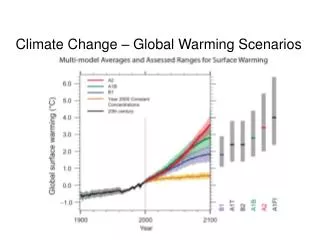
Downscaled Data for Idaho • Using three models selected by CIG as spanning the range of potential change: • low (GISS) • medium (ECHAM) • high (IPSL) • Two climate change scenarios: • A2 - aggressive use of fossil fuels • B1 - more ecologically friendly http://www.ipcc.ch/SPM2feb07.pdf
Differences in April (1990/99 - 2090/99) ECHAM5 A2 Tmax ECHAM5 B1 Tmax
ECHAM5 A2 Tmin ECHAM5 B1 Tmin
IPSL A2 Tmin IPSL A2 Tmin
Current Research • Temperature downscaling is nearly completed. • Precipitation downscaling is in progress. • Predicting future snow cover extent over Idaho based on relationship between historical snow images and past climate model output. Then impose future climate change. • Visualizations • Animations of snow cover forecasted to 2100 with Snow Water Equivalence (SWE) and Thermometer indicators • Spatial depiction of trends of temperature and precipitation in Idaho • Applying climate change scenarios to hydrologic models in small to medium-sized watersheds.
Future Research • New EPSCoR Research Infrastructure Improvement (RII) proposal, “Water in a Changing Climate” • Connect with CIG • Focus on Snake River Basin • Connection between surface and ground water • Interactions of hydrology with biology and economics/policy • If funded, $2M / per year for 5 years • Develop junior faculty and make strategic new hires.