Download
1 / 2
20 likes | 165 Views
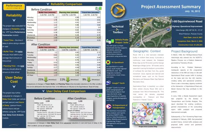
Reliability Comparison. Project Assessment Summary. Performance. Reliability The project was evaluated for changes in Reliability using the VPP Suite Performance Summaries module: Travel Time – the time it takes to drive along a stretch of road

E N D
Reliability Comparison Project Assessment Summary Performance • Reliability • The project was evaluated for changes in Reliability using the VPP Suite Performance Summaries module: • Travel Time – the time it takes to drive along a stretch of road • Buffer Time – the extra time you must add to your average trip to ensure on time arrival • Planning Time – the totaltime you should allow to ensure on time arrival • User Delay Cost • • The project was further evaluated for changes in Delay Cost (total, per vehicle and per person) and Hours of Delay (person-hours, vehicle-hours and per vehicle) using the VPP Suite User Delay Cost Analysis module. a s s e s s m e n t Before Condition July 16, 2012 I-80/Squirrelwood Road Highway Operational Improvement Interchange #56; MP 56.76 – 57.47 West Paterson, Passaic County Start Date: June 8, 2007 Completion Date:March 3, 2008 Construction Cost: $1,282,304 Squirrelwood Road Technical Toolbox Vehicle Probe Project Suite After Condition The VPP Suite is a Flash-based web site that supports operations, planning, analysis, research & performance measure generation using probe data. Geographic Context Project Background Route I-80 is a vital east-west interstate facility in northern New Jersey. It provides a continuous route between the Delaware Water Gap (at the PA border) and the George Washington Bridge (at the NY border) and is essential in serving the bedroom communities of northeast NJ and New York City, goods movement (local, regional and national) and recreational areas, such as the Pocono Mountains and Delaware Water Gap National Recreation Area. Squirrelwood Road is classified as a urban minor arterial (County Route 636) and is accessed from I-80 at Interchange 56. This road serves the densely populated municipalities of Paterson and West Paterson in Passaic County. In March, 1990, the I-80/Squirrelwood Road interchange was entered into the NJDOT’s Pipeline Process via a Problem Statement generated by Township officials. According to the Problem Statement, inadequate capacity at the unsignalized intersection of the WB exit ramp of I-80 with Squirrelwood Road causes traffic to backup on the ramp and into the I-80 mainline, creating safety and operational problems. There is also a secondary capacity constraint at the intersection of Squirrelwood Road and Glover Avenue that may contribute to this problem. In June, 1992, a Needs Assessment report was prepared by the Bureau of Transportation and Corridor Analysis. This report described the existing conditions, general characteristics of the surrounding region, traffic analyses and proposed improvement concepts. Subsequently, a Tier II Screening Report was completed in February, 2005, that presented accident history, revised traffic analyses and proposed traffic control and geometric improvements. NJ OpenReach NJ OpenReach is a web-based, multi-modal regional (NY/NJ/CT) tool that integrates incidents, construction, travel times and video. 11% 9% 25% (Weekdays) (Weekdays) (Weekdays) Googletm Earth Comparisons of changes in Travel, Buffer and Planning Times show favorable reductions in the After condition that can be attributed to the improved flow in the WB lanes of I-80 prior to the Squirrelwood Road off-ramp. Googletm Earth is a virtual globe and geographical information program that maps the Earth using superimposition of satellite imagery, aerial photography and GIS 3D. User Delay Cost Comparison Before Condition After Condition NJ Department of Transportation This Summary incorporates data, analyses and reports by various NJDOT Units, such as: Data Development, Safety, Mobility and Systems Engineering, Project Management and Systems Planning. Comparisons of changes in UserDelay Cost show substantial reductions in cost and hours of delay in the After condition, across all categories. Project Area Location Map
Project Element Location MapAverage Speed Change Speed Threshold Change Mobility • Project Detail • The project will eliminate the bottleneck occurring at the intersection of Squirrelwood Road and the WB I-80 off ramp, that causes traffic to queue back down the ramp and deceleration lane and into the I-80 through lanes, by: • Signalizing the intersection of the WB off-ramp and Squirrelwood Road (to reduce left turn delays and queues) • Widening the ramp to 2 lanes (for extra storage capacity and to remove the conflict of left turning vehicles blocking right turning vehicles) • Extending the deceleration lane leading to the WB I-80 off ramp (for extra storage capacity) • There are no right-of-way issues with widening the ramp or extending the deceleration lane on I-80. a s s e s s m e n t Before Condition (Data averaged across the entire year) Before Condition (Percent of readings below speed thresholds) Squirrelwood Road 5 PM Average Speed: 47 MPH 5 PM 34% 1 3 9% 2 After Condition (Percent of readings below speed thresholds) After Condition (Data averaged across the entire year) Signalize the Squirrelwood Rd/I-80 WB off-ramp intersection Widen the off-ramp from 1 to 2 lanes Extend the deceleration lane 5 PM Average Speed: 53 MPH 5 PM 16% 7% Highway Capacity Software Intersection Analysis During the PM Peak Hour (5:00 PM), there has been a 13%increase in speed along the section of WB I-80 approaching the Squirrelwood Road interchange (blue highlight) since the implementation (and “shake-out” period) of the project. (the AM Peak Hour showed a 4% increase in speed). There has been a substantial improvement in speeds that fall below 45 MPH (a threshold indicating the beginning of congested conditions). In the “Before” condition, PM Peak Hour (5:00 PM) , 34% of readings were < 45 MPH. In the “After”, the percentage of readings dropped to 16%, an overall decrease of 53%. Congestion Comparison Bottleneck Comparison After Condition Before Condition Using a VPP congestion scan, comparisons between the before & after condition show improvement in congestion intensity and duration in the 5 PM WB direction of I-80, prior to the Squirrelwood Rd Interchange. Scan Resul ts HCS analysis indicates a substantial LOS and Avg. Queue improvement on the ramp approach of the intersection with only a slight LOS degradation on the Squirrelwood Rd. approaches. * This queue represents the available storage on the ramp. Observed queue extends as far back as 1,500’ on the I-80 WB mainline. Note: LOS under signalized conditions is not provided for channelized right turn. Results would be similar to un-signalized analysis.