Download
1 / 24
250 likes | 438 Views
Mapping of Understory Lichens with Airborne Discrete-Return LiDAR Data. Ilkka Korpela Dept. For. Res. Management, Helsinki Faculty of Forest Sciences, Joensuu ILKKA.KORPELA@HELSINKI.FI ILKKA.KORPELA@HUT.FI. Contents Objectives LiDAR? Intensity? Experiment on ground lichen mapping

E N D
Mapping of Understory Lichens with Airborne Discrete-Return LiDAR Data Ilkka Korpela Dept. For. Res. Management, HelsinkiFaculty of Forest Sciences, Joensuu ILKKA.KORPELA@HELSINKI.FIILKKA.KORPELA@HUT.FI
Contents Objectives LiDAR? Intensity? Experiment on ground lichen mapping Use of LiDAR intensity and optical data – Outlook
Objectives • Airborne laser scanning (ALS, LiDAR) is an effective, newish tool for assessing "environmental geometry" in 3D • Canopy Height Modeling, GapsCanopy Density + Allometric reasoning => Tree BiomassTerrain profile & Derivates • Tree Biomass needed on per species basis; consider e.g. management, wood procurement, stratification issues • Allometric reasoning works better with the correct species information, LAI-estimation alike.
LiDAR all about geometry? (NIR, G, R)1 km AGL (NIR, G, R)& LiDAR-heights (NIR, G, R)& LiDAR-Backscatter
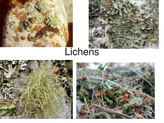
Intensity information in LiDARs should be looked into. Explorative, empirical study to learn more about LiDARsQuest for solvable and relevant topic... (Tree species recognition would be too ill-posed and ugly to start with) Kaasalainen & Rautiainen (2005, J Geophys. Res. 110 D20102)Cladina sp. showed high backscatter intensities in laboratory tests with a 1064-nm and 633-nm LiDAR “The results (extremely strong backscattering surge) imply that lichens could be separated from other surfaces, such as soil and forest understory, by their unusually strong hot spot peak amplitudes” “in situ” -test of the hypothesis/conclusion for Cladonia P. Browne or (formerly) subgenus Cladina (Nyl.) Nyl.
LiDAR, Intensity? A discrete-return LiDAR follows the black-box –principle. 1-4 return echoes are registered along with intensity values. User knowledge of the instrument is limited.Full-waveform digitization is possible. Returning (& outgoing).Observed intensity is affected by many factors
Experiment on ground lichen mapping Components1 LiDAR, two instruments2 Reference measurements of lichens, 32 m 30 m3 Test of the hypothesis
Photogrammetric mapping of understory flora, 2007Oblique images, Powershot G6 consumer-grade camera, 63° dFOV, quadrangle coverage with 42-64% and 25% image overlaps, 0.5-0.8 mm pixels, 36 control points (internal).
Image quality • semi-overcast WX, shaded areas • color fringing in edges
- 27 “flight lines”, 39 images per line 1053 images • - 1.2 0.8 m photo-spacing • - Orientation by means of triangulation, 11040 image points, ouch...(17553 unknowns in non-linear regression) • Accuracy 5–7 mm in XY and 23 mm in Z • Required lens-distortion correction!
Camera calibration – 3D test field @ HUT/PERS-LaboratorySolve focal lenght, principal point position, radial & tangential lens distortions, CCD-shear/affinity
CCD 7.1 mm 5.3 mm3072 2304 pixelsLens errors up to 80 pixels or 0.186 mm in the focal plane
Orthomosaic Using the 1053 images and a DEM interpolated from camera positions, constructed an orthomosaic with 2.5 mm pixels (12k 14k) It’s accuracy was evaluated in 20 points, SD of differences 3 cm in X and Y.
Bringing the plot and the orthomosaic to “world coordinates” Trees positioned in aerial images observed from plot corner poles in “polar observations”
Digitization of lichen polygons in the orthomosaic followedNow it was possible to extract 1-return pulses inside the plot and carry out inclusion testing to see if a LiDAR pulse had hit a lichen mat or other type of surface
Translating the lichen map and testing for intensity differences between lichen and other surfaces Peak in class separability (measured in t-statistics) occurred at XY offsets of X=−0.09 m and Y= −0.04 m and X= −0.08 m and Y= −0.19 m. ALS50 ALTM3100
Best-case separability, ALS50, LDA-classification accuracy 73.6 % (69.5% for raw intensity obs) In ALTM3100, best-case LDA-classification accuracy 64.4% (62.4% for raw intensities)
Discussion of Results A higher (than other understory vegetation) backscatter surge was observed in situ for Cladina surfaces Separability was weak, however (74% at best), and mapping/monitoring applications won’t be possible The photogrammetric mapping of the understory Flora was successful, the lichen map had an internal accuracy of ± 0.03 m and an external accuracy of 0.07 m. Missed details?Remote Sensing of Environment will publish the study.
Tree species identification – Outlook for the co-use of LiDAR (intensity) with images Use LiDAR geometry for coarse positioning of trees, refine with images (multi-image matching). Iteratively solve crown geometry and tree species by using the LiDAR point cloud, multi-angular (BRF) spectral observations, LiDAR intensity metrics and allometric reasoning. P S B P S B
Seedling stand assessment & management – Co-use of LiDAR (intensity) with images
On behalf of Metsähallitus and University of Helsinki: You are welcome to experiment in Hyytiälä.