Download
1 / 29
290 likes | 405 Views
Comparison of LIDAR Derived Data to Traditional Photogrammetric Mapping. David Veneziano Dr. Reginald Souleyrette Dr. Shauna Hallmark GIS-T 2002 November 19, 2014. USDOT Remote Sensing Initiative. NCRST-Infrastructure

E N D
Comparison of LIDAR Derived Data to Traditional Photogrammetric Mapping David Veneziano Dr. Reginald Souleyrette Dr. Shauna Hallmark GIS-T 2002 November 19, 2014
USDOT Remote Sensing Initiative • NCRST-Infrastructure University of California - Santa Barbara (lead), University of Wisconsin, University of Florida, Iowa State University • Sponsored by • USDOT • RSPA • NASA • Joint endeavor with Iowa DOT
Problem • Highway location/relocation studies require surface terrain information • economically site new or relocate existing infrastructure facilities • make final design plans • Current data collection methods for surface terrain modeling • Electronic Distance Measurement (Total Station) • Real Time Kinematic Global Positioning Systems • Photogrammetry (aerial photography)
Limitations of Current Data Collection Methods • Labor Intensive • Time-consuming • Costly • Dictated by conditions (time of year, sun angle, weather, etc.) • May require data collectors to locate in-field
Solution • Evaluate use of LIDAR (Light Detection and Ranging) as alternative to current data collection methods • Feasibility • Accuracy • Application • Costs and benefits
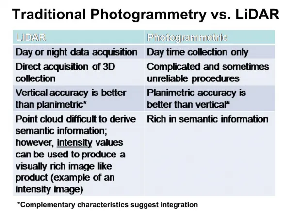
LIDAR: The Technology • Emits stream of light pulses and records return time and angle of emissions • GPS -- positional information • Inertial measuring systems measure roll, pitch, and yaw
LIDAR: The Technology • Corrects distance measurement for each pulse • Calculates corrected surface coordinates (x, y, z) • Data processing can extract measurements of the bare ground (removal of vegetation, snow cover, etc.) • Digital aerial photography can be taken at the same providing an additional layer of data.
Advantages of LIDAR • Ease of data acquisition • Increased ability to determine surface elevations in difficult areas • Significantly less time for creation of elevation data • Less dependent of weather, time of year, time of day
Pilot Study • Iowa 1 Corridor • Already mapped using photogrammetry (1999) • Project Scope • Compare accuracy of LIDAR vs. photogrammetry • Evaluate use in highway location studies • Compare costs and benefits of LIDAR vs. conventional survey techniques
Data Collected • LIDAR XYZ ASCII • First Return • Last Return • Bare Earth • 1 Foot resolution digital orthophotos
Incomplete filtering of structures and trees Row crops still present Data Issues
Accuracy Comparison Techniques • DTM Comparison – Compare elevations extracted from digital terrain models developed from LIDAR to reference data to determine elevational differences between the two datasets • Point Interpolation - Bilinearly interpolate LIDAR points to reference points to obtain elevational differences (only performed on points lying on flat surfaces) • Nearest Neighbor Comparison – Select LIDAR points within a specified tolerance (both x and y) of the reference points to calculate elevational differences between the two datasets
“Pure” Accuracy Comparison • Nearest Neighbor Comparisons • Photogrammetry is baseline • LIDAR vs. Photogrammetry • Photogrammetry and LIDAR vs. GPS control (future)
Technique • Join Photogrammetry point table to LIDAR point table • Resulting table produces horizontal distance field between LIDAR and Photogrammetry points • Query out points within desired distance (ex. 15 cm)
Test of Vertical Accuracy • The National Standard for Spatial Data Accuracystates that twenty or more test points are required to conduct a statistically significant evaluation • A Root Mean Square Error Test can be performed on 20+ common x, y values between the reference and LIDAR datasets to determine the vertical accuracy
Highway Location Application • Compare area calculations of different alignments produced from photogrammetry and LIDAR data • Does LIDAR produce more accurate calculations of the area above and below a baseline (photogrammetry)? • If so, LIDAR may produce cost savings as designers would have information regarding where more or less earthwork would be required, allowing them to plan the most efficient route • Area calculations produced through GIS analysis could yield cost savings by guiding designers in finding optimal routes
Preliminary Results: 3 Alignments • Alignments approx 19,000+ meters long (11 miles) • Minimum elevation difference – 5cm • Maximum elevation difference – 2+m LIDAR Above, Below and Cumulative Diff are in squared meters
Future Work: Compare Costs and Benefits • Accurate LIDAR would be capable of supplementing photogrammetry • If LIDAR collection costs are comparable or lower than traditional methods, such data collection would be more cost effective
Compare Costs and Benefits • Cost/Benefit analysis will determine if LIDAR can financially compare to photogrammetry • Compare costs of data collection methods • Examine data delivery times and the cost savings derived from more rapid delivery
Conclusions • LIDAR is still an emerging and developing technology compared to photogrammetry • Usefulness of LIDAR limited primarily to leaf-off collection for highway design needs • Additional photogrammetric data collection will still be needed to meet final design needs
Conclusions • Accuracy of LIDAR is better on hard, flat, bare surfaces as opposed to surfaces covered by vegetation • Areas with steep changes in elevation (ex. ditches) may be less accurately represented • LIDAR accuracy in areas with heavy vegetation coverage (ex. row crops) is poor
Conclusions • Elevational profiles between LIDAR and Photogrammetry surfaces roughly match • Area estimations show that LIDAR alignments are, on average, 30-40 cm above or below those of photogrammetry for the length of each alignment • Area estimations may be influenced by vegetation, etc.