Download
1 / 35
460 likes | 1.1k Views
Wetlands of Florida. Ehringer. Definition. Wetlands are land depressions where water inundates the soil for periods of time from a few weeks to an entire year. .

E N D
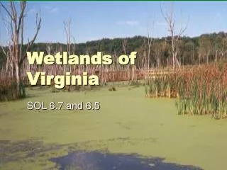
Wetlands of Florida Ehringer
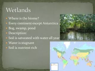
Definition Wetlands are land depressions where water inundates the soil for periods of time from a few weeks to an entire year.
In 1979, a comprehensive classification system of wetlands and deepwater habitats was developed for the U.S. Fish and Wildlife Service. Under this system, wetlands are of two basic types: coastal (also known as tidal or estuarine wetlands) and inland (also known as non-tidal, freshwater, or palustrine wetlands).
Marine wetlands • Open Ocean overlying the continental shelf and coastline exposed to waves and currents of the open ocean shoreward to (1) extreme high water of spring tides; (2) seaward limit of wetland emergents, trees, or shrubs; or (3) the seaward limit of the Estuarine System, other than vegetation. Salinities exceed 30 parts per thousand.
Estuarine wetlands • Deepwater tidal habitats and adjacent tidal wetlands that are usually semi-enclosed by land but have open, partly obstructed, or sporadic access to the ocean, with ocean water at least occasionally diluted by freshwater runoff from the land. The upstream and landward limit is where ocean-derived salts measure less than .5 parts per thousand during the period of average annual low flow. The seaward limit is (1) an imaginary line closing the mouth of a river, bay, or sound; and (2) the seaward limit of wetland emergents, shrubs, or trees when not included in (1).
Riverine wetlands All wetlands and deepwater habitats contained within a channel except those wetlands (1) dominated by trees, shrubs, persistent emergents, emergent mosses, or lichens, and (2) which have habitats with ocean-derived salinities in excess of .5 parts per thousand.
Lacustrine (lakes) wetlands Wetlands and deepwater habitats (1) situated in a topographic depression or dammed river channel; (2) lacking trees, shrubs, persistent emergents, emergent mosses, or lichens with greater than 30% areal coverage; and (3) whose total area exceeds 8 hectares (20 acres); or area less than 8 hectares if the boundary is active wave-formed or bedrock or if water depth in the deepest part of the basin exceeds 2 m (6.6 ft) at low water. Ocean-derived salinities are always less than .5 parts per thousand
Palustrine (marsh) wetlands All nontidal wetlands dominated by trees, shrubs, persistent emergents, emergent mosses, or lichens, and all such tidal wetlands where ocean-derived salinities are below .5 ppt. This category also includes wetlands lacking such vegetation but with all of the following characteristics: (1) area less than 8 ha; (2) lacking an active wave-formed or bedrock boundary; (3) water depth in the deepest part of the basin less than 2 m (6.6 ft) at low water; and (4) ocean- derived salinities less than .5 parts per thousand.
Delineation of Wetlands Many systems have been developed to determine the extent, boundaries and physical characteristics of wetlands. Although each classification system relies upon some unique aspect of wetlands, they all use the following characteristics (next slide):
Aquatic Plants: the identification of aquatic plants found in a wetland are classified and measured. The presence of aquatic plants in a location that is potentially a wetland is a strong indicator of water inundation. • Facultative wet plants (FACW): these are plants that may be found in upland areas, but are more likely found in low areas (wetlands) that have frequent inundation. • Hydric soils: the measurement of the soils in a wetland. Soils are telltale signs of the boundaries of a wetland. In addition, the saturation of the soil with water is also a good indicator.
Obligate plants: are those plants that are only found in areas that are subject to surface water inundation. Identification of these plants within an area is a clear indicator of a wetland. • Saturation: the extent to which water tables can create anaerobic conditions in the soil profile. Anaerobic soil conditions are typical of Florida wetlands.
The procedure in evaluating a wetland is to characterize the plants within the location, whether obligate, facultative, aquatic, etc. Then the soils are tested to determine their characteristics (dark surface, organic accretions, oxidized rhizomes, stratified layers, anaerobic, iron, manganese, mottles and marl). Finally, indicators of water inundation are looked for. These may include water rings around tree trunks, algal mats, mosses, liverworts, nonvascular plants, drift lines, plant adaptations to inundation, water flow indicators, tussocks, and hummocks.
Cypress swamps Cypress swamps (strand swamps) are shallow, forested, usually elongated depressions or channels that are dominated by bald cypress trees. They are generally situated in troughs in a flat limestone plain. Typical plants include red maple, laurel oak, cabbage palm, strangler fig, red bay, sweet bay, coastal plain willow, wax myrtle, buttonbush, royal primrose, poison ivy, swamp lily, leather fern, royal fern sawgrass, swamp primrose, water hyssop, smartweed, and arum. Canopy plants are mainly temperate, while understory and epiphytic plants are mainly tropical. Small young trees at the outer edge of the swamp grade into large old trees in the interior, giving a strand a distinctly rounded, cross-sectional profile.
Ecology There are two types of cypress trees in Florida: bald cypress and pond cypress. Bald cypress grows in and along flowing water: river swamps, stream banks, spring runs and lakeshores. Pond cypress is limited to ponds with still or slow-moving water. When pond cypress is faced with soils poor in nutrients, such as the marl soils in the Everglades or the clay soils in the Florida panhandle, growth may be extremely slow giving the trees a stunted or dwarfed appearance.
The Everglades The everglades (the river of grass) is Florida’s most famous wetland. It is an enormous expanse of grasses that occupy the southern part of the state from Lake Okeechobee to Florida Bay. The freshwater supply comes from rain on the Kissimmee River basin and southward, mostly in May through October. Evaporation, transpiration, and runoff consume four-fifths of the rain, which may total 40 to 65 inches (100 to 165 cm) per year. The natural cycle of freshwater circulation historically builds up in shallow Lake Okeechobee. It averages 12 feet (3.7 meters) deep and covers 730 square miles (1890 square kilometers). Then, the water flows south through the glades.
Parts of the Everglades • Marine: Florida Bay, the largest body of water within Everglades National Park, contains over 800 square miles (2072 square km) of marine bottom, much of which is covered by seagrass. The seagrass shelters fish and shellfish and sustains the food chain that supports all higher vertebrates in the bay. • Mangroves: Mangrove forests are found in the coastal channels and winding rivers around the tip of South Florida. This estuary system is a valuable nursery for shrimp and fish. During the dry months, wading birds congregate here to feed. Many bird species nest in the mangrove trees. • Coastal Prairie: Located between the tidal mud flats of Florida Bay and dry land, the coastal prairie is an arid region of salt-tolerant vegetation periodically flooded by hurricane waves and buffeted by heavy winds.
More parts • Freshwater Marl Prairie: Bordering the deeper sloughs are large prairies with marl sediments, a calcareous material that settles on the limestone. The marl allows slow seepage of the water but not drainage. Though the sawgrass is not as tall and the water is not as deep, freshwater marl prairies look a lot like freshwater sloughs. • Freshwater Slough: The slough is the deeper and faster-flowing center of a broad marshy river. This "fast" flow moves at a leisurely pace of 100 feet (30 meters) per day. Dotted with tree-islands called hammocks or heads, this vast landscape channels life-giving waters from north to south. Everglades National Park contains two distinct sloughs: Shark River Slough, the "river of grass;" and Taylor Slough, a narrow, eastern branch of the "river." • Cypress: The cypress tree (Taxodium spp.) is a deciduous conifer that can survive in standing water. These trees often form dense clusters called cypress domes in natural water-filled depressions.
More • Hardwood Hammocks: Hammocks are dense stands of hardwood trees that grow on natural rises of only a few inches in the land. They appear as teardrop-shaped islands shaped by the flow of water in the middle of the slough. Many tropical species such as mahogany (Swieteniamahogoni), gumbo limbo (Burserasimaruba), and cocoplum (Chrysobalanusicaco) grow alongside the more familiar temperate species of live oak (Quercusvirginiana), red maple (Acer rubum), and hackberry (Celtislaevigata).
Salt Marshes • Salt marshes border the large shallow bays and estuaries where inland rivers empty into the sea. Tidal creeks meander through them, rising and falling twice a day, flooding the marsh, and then retreating. From a distance, salt marshes look like broad, flat, treeless meadows covered with waving grasses and open expanses of sand and salt. • Despite their ecological importance, nearly half of all Florida's marshes, both saltwater and freshwater, have been lost to development, dredging, and mosquito control impoundments during the past 100 years. • Some salt marshes are non-tidal, many are impounded, and their structure and composition is dynamic due to water level management and geographic location. Salt marshes are dominated by almost pure stands of Spartina alterniflora, cordgrass (S. bakerii), black rush (Juncus roemerianus), salt grass (Distichlisspicata), and other salt tolerant grasses. Many salt marshes are comprised of shrub-sized mangroves, Batismaritima, Salicornia spp., and salt grass.
Salt marsh food chain The foundation of the salt marsh food chain is the grasses, and the grasses derive their energy from the sun through photosynthesis. The overall food web for the marsh is a detrital based food web. Many other ecosystems are based on the model where primary consumer or herbivore is eaten by secondary consumer, is eaten by tertiary consumer, etc. In the salt marsh, most of the primary production (the grasses) is not passed directly to herbivore through grazing, but rather the grasses enter the food web after becoming enriched as detritus. It has been estimated that between 45 and 60% of the organic matter initially in the grasses enters the detrital food web, the rest being eaten by herbivores. The detritus is said to be enriched because the action of microorganisms, particularly bacteria, breaks down the plant cellulose and add their own protoplasm to the mix.
Juncus • Black Needlerush is an important plant in the seaside habitat, inland from the Spartina growths. This plant is a tall slender grass-like plant that has narrow leaves that emerge at the top in a sharp point. These points can easily puncture the skin of persons walking among the plants. • The Juncus community is usually found more shoreward from the Spartina community and is in areas that are irregularly flooded with salt water at the highest of high tides. At low tides the community is flooded with fresh water from nearby rivers and streams. It is, therefore, on the fringe of the brackish water embayment.
Spartina Smooth cordgrass looks like a typical "grass" having long thin shoots that grow upward from the sediment. It has a prominent ecological importance in its location along the shoreline. One of the more important roles is its ability to stabilize the shore. The roots hold the sediment in place and prevent it from washing out to sea. Because of this role, smooth cordgrass is often planted along new shorelines that are created for highways and bridges. Another role for cordgrass is that it is home for many organisms. While walking along the shoreline in the grasses two organisms are readily apparent: the sand fiddler crab (Ucapugilator) and the marsh periwinkle (Littorinairrorata).