Download
1 / 1

E N D
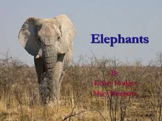
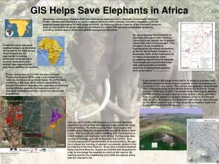
GIS Helps Save Elephants in Africa Geographic Information Systems (GIS) have become an important tool in Elephant Conservation efforts in Kenya. Wildlife populations are at risk throughout Africa for many reasons, including competition with the growing human population for land usage and food. By mapping different aspects of the elephant’s behavior, such as eating patterns, social interaction and migration routes, GIS can help conservation groups by providing detailed data to assist with wildlife management decisions. By understanding the movement of elephants throughout their territory, researchers can identify the migration routes that need to be protected. “The relevance of our research is highlighted by the recent recognition, at the 5th World Parks Congress in September 2003, of the importance of corridors in planning for meta-populations and the need to integrate local people and un-protected areas with national parks and wildlife agencies in management planning and conservation.”(www.savetheelephants.com/tracking) http://animals.nationalgeographic.com/animals/mammals/african-elephant.html Traditional maps that show elephant ranges, as illustrated above and to the right, do not allow researchers the opportunity to overlay behavioral observations or provide researchers with enough data regarding the population stability of a species. www.elephanttag.org/General/range_african.html www.savetheelephants.com/files/pdf/publications/2008 Today, researchers in the field can place a Global Positioning System (GPS) collar on an elephant and track its movement on an hourly basis. The GPS data is plotted on a GIS map, which allows researchers to overlay information regarding the vegetation preferences during different seasons, the migration pattern of individual elephants and their interaction with human populations. A key benefit of GIS usage in the field is its ability to use data from different sources to create a more complete picture for researchers, as shown in the map below. “The surface topography is derived from data collected from the Space Shuttle Endeavour during an 11-day mission in February of 2000. The Shuttle Radar Topography Mission (SRTM) obtained elevation data on a near-global scale to generate a high-resolution digital topographic database of Earth. Overlaid on that, we have, for example, the Amboseli road network, data collected by the AERP research team driving along the ecosystem roads and tracks with hand-held GPS devices.”(Croze, 2007, www.elephanttrust.org) One source of conflict with humans occurs when elephants experience a natural food shortage and begin eating the crops of local farmers. The farmers protect their food supply and livelihood by killing the elephants that repeatedly destroy their crops. This is a natural conflict resulting from the proximity in which humans and elephants live in Africa. Cutting-edge Geo-fencing technology can help to decrease this conflict. As a virtual computerized representation of an actual fence, the geo-fence allows the tracking of elephant movements relative to the boundaries of the Park Reserve. Every time a tracked elephant leaves the Park Reserve, rangers are notified and dispatched in order to encourage the elephant to return to the reserve. By reacting quickly, the neighboring crop fields are spared, along with the elephant’s life. Both maps: Croze, 2007, www.elephanttrust.org/node/213 www.savetheelephants.com/tracking.html Submitted by Marnie Sippel, GIS346 Fall 2008 Elephant background photo: Sippel, 2005 • Works Referenced: • www.elephanttrust.org • www.savetheelephants.com • www.nationalgeographic.com • www.elephanttag.org