Download

1 / 28
280 likes | 563 Views
Classification of Remotely Sensed Data. General Classification Concepts Unsupervised Classifications. Learning Objectives. What is image classification, and what are the three general classification strategies? What are the main steps required to classify images?

E N D
Classification of Remotely Sensed Data General Classification Concepts Unsupervised Classifications
Learning Objectives • What is image classification, and what are the three general classification strategies? • What are the main steps required to classify images? • What is unsupervised classification, and what are its advantages and disadvantages?
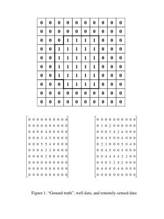
Wyoming land cover modified from USGS Gap Analysis Program data • Based on Landsat TM data • Used a supervised classification technique called CART analysis • Legend is aggregated from much more detailed legend
USGS National Land Cover Database (2006) • Based on Landsat TM data • Used CART • Legend is not aggregated – not as detailed as GAP U.S. Landcover - MODIS
What is Image Classification? • Process of grouping image pixels into classes that represent self-similar features or themes Analogous to any classification exercise.
How? • Three general approaches: • Manual interpretation (e.g., photointerpretation, “heads-up digitizing”) • Unsupervised classification of digital data • Supervised classification of digital data Sequence of methods similar for all three!
Group Exercise • Divide yourselves into groups of ~3 • Each group gets a collection of “objects” • Divide the objects up into 4 groups, writing down the questions you ask and the solutions you use to do this
A word about manual classification • Manual image interpretation was at the core of remote sensing for much of its history • Still perfectly viable today in some situations • Usually requires people trained to integrate image clues to make decisions about boundary placement • Can use computers for on-screen interpreation
General Classification Steps • Field reconnaissance • Development of a classification scheme (legend) • Image enhancement (as needed) • Classification using manual or digital techniques Incorporation of ancillary data (as needed) • Accuracy assessment • Iterative refinement
Field Reconnaissance • Critical for understanding the distribution of your theme in the real world • Understanding of ecology, geology, geomorphology, etc. • Helps you choose useful ancillary data • Useful for interpreting the imagery • Nice excuse to get out once in a while
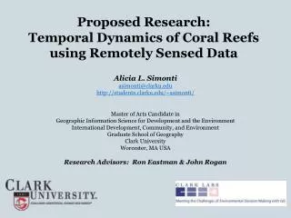
What characteristics of this landscape might be important for making a map using satellite data?
Developing Classification Schemes (Legends) • How many types do you want to map? • How should you divide up the feature you are interested in? • Can be very controversial!
Classification Schemes(List of types to map) • Must be useful (how will map be used?) • Must be detectable using the data you have • Usually hierarchical • Categories must be mutually exclusive • Require explicit definitions of each class
Classification Scheme -- Example • Vegetated • Forest • Evergreen • Spruce-fir forest i. Spruce-fir with winterberry understory • Lodgepole pine forest • etc. • Deciduous • Shrubland • Non-Vegetated
GroupsGenerate a classification scheme for mapping the main UW campus using Google Earth imagery
Digital classification • Creating thematic classes based on groups of similar digital numbers (DNs) • Statistical clustering of the data (lumping spectrally similar pixels into the same class) • Spectral vs. informational classes • Sometimes combine spectral classes together to make informational classes
Classification Use many bands at once to create a map of classes
Classification Strategy • Unsupervised – computer clusters pixels based only on the similarity of their DNs. • Supervised – computer uses training data—examples of target classes—and assigns pixels to the closest training class using similarity • Others (neural networks, fuzzy logic etc.)
Unsupervised Classification 2-bands Max . . . . . . . . Class . . . . . . . . . . . . . . . . . . . . . . . . . . . . . Band Y . . . . . . . . . . . . . . . . . . . . . . . . . . . . . . . . . . . . . . . . . . . . . . . . . . . . . . . . . . . . . . . . . . . . . . . . . . . . . . . . . . . . . . 0 Band X Max
Unsupervised Classification 3-bands 1 pixel 1 Class
Unsupervised Classification • Choose bands, indices, enhancements, etc. that highlight differences in your classes • Decide how many groups (classes) you want • Choose a grouping algorithm • Simple clustering, K-means, etc. • Classify the image • Label (and aggregate) classes and evaluate the results
Advantages of Unsupervised Classifications • No extensive prior knowledge of map area required (but you have to label the classes!) • Classes are based only on spectral information (spectral classes), so not as subjective as when humans make decisions
Disadvantages of Unsupervised Classifications • Spectral classes do not always correspond to informational classes • Spectral properties of informational classes change over time so you can’t always use same class statistics when moving from one image to another
Grouping Algorithms • Statistical routines for grouping similar pixels together • Operate in feature space • Differ in how they: • Determine what is similar (distance measures) • Determine the statistical center (centroid) of a class
Unsupervised classification of Martian terrain. From Stepinski and Bagaria. 2009. IEEE Geoscience and Remote Sensing Letters.