Download
1 / 17
170 likes | 309 Views
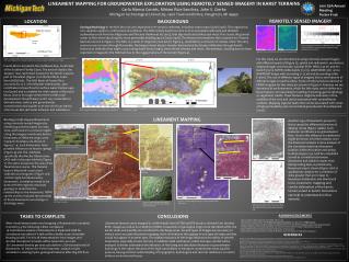
Development Of A Geospatial Interactive Database Of Historic Remotely Sensed Imagery. Beziel Shambamuto. The Project. Dr Harold Macdonald collected imagery from five aerial and satellite platforms between 1960 and 1980, for geologic research. INTRODUCTION –Identification of available

E N D
Development Of A Geospatial Interactive Database Of Historic Remotely Sensed Imagery. Beziel Shambamuto
The Project. • Dr Harold Macdonald collected imagery from five aerial and satellite platforms between 1960 and 1980, for geologic research. • INTRODUCTION–Identification of available resources and highlighting of the importance of building the database. • METHODOLOGY – Techniques used to design and construct the database, and methods used for georeferencing and digitizing flight maps. • RESULTS – Development of an organized interactive database, with metadata, and flight line maps.
Background • Dr Harold MacDonald collected imagery from five platforms, and donated the collection to the Libraries when he retired. • Satellite platforms were SEASAT, SIR-A, SKYLAB and the aerial platforms were Aerial Photography and Aircraft radar • Imagery from each platform is described by its unique metadata, however, the imagery will not all be scanned • Metadata about the imagery varies from platform to platform • The overarching goal of the current research is the development of a geospatial digital library collection of the historical remotely sensed imagery.
Introduction. • Historic imagery is important for analyses of landscapes, forestry and water conservation, and global change • The database under construction gives researchers access to the imagery from any place across the world via internet • Remote sensing sensors were used to acquire the images • Current steps involve the construction of a database that will hold metadata, flight maps and creation of relationships between the metadata and flight maps
Imagery • Below is an example of imagery from Aircraft Radar, that was taken over Panama. Film Format: Positive Scanner Used: Epson 10000XLScan Resolution: 1200 dpi Scan Type: 16-8 bit grayscale
Methodology. GeoDatabase Construction…Tables AND Maps. • Creating the structure of a database • Data to be included in Database • Relationships between data within Database GeoDatabase. GeoDatabase Organization.
Methodology GeoReferencing • SEASAT/SIR-A • Import scanned map into ArcMap • Created a point shape file in ArcMap, and assigned Longitude and Latitude values to the points in space • Tie the points that are on scanned map to points that they represent in space • Changed projection from Mercator projection to World Geographic Coordinate System • Aircraft Radar • Scanned map had no coordinates displayed, • Used points such as State corner intersections to tie points from the scanned map to a georeferenced United States shape file • Changed projection from Lambert Conformal Conic projection to World Geographic Coordinate System
Methodology. Database Construction…Tables. • The metadata tables contain the following fields as headers: ObjectID, Storage, Geographic Location, Datatake, Format, Notes, Digitized and Orbit. • ArcCatalog is used to store the tables in a database format, ArcMap is used to edit the Tables. • The tables for the flight paths and flight maps contain the following fields: objectId, Shape, Shapelength, Shape Area, Datatake, FilmId. • Created new field to identify imagery uniquely: Orbit_Datatake, and establish relationship between flight maps, flight paths and metadata tables
Methodology. Digitizing…Techniques. • ArcMap is used to digitize scanned flight maps, after georeferencing the flight maps • Vertices that are closer together give better results Digitizing an Aircraft Radar flight path
Methodology. Digitizing… Flight Map SIR-A, 11/12/1981 • Scan map using Silverfast Ai, • Import to ArcMap, • Digitize flight lines into polygons • Particular attention given to flight paths and orbits that overlap • Verify that metadata is correct for area covered by flight paths Lawrence, G. M. and P. H. A. Martin-Kaye. 1983. The Application of Satellite Imaging Radars over Land to the Assessment, Mapping and Monitoring of Resources. Philosophical Transactions of the Royal Society of London. Series A, Mathematical and Physical Sciences. 309. 1508:295-314.
Methodology. Digitized…
Methodology. Digitizing… Flight Maps and Flight Paths Skylab, Aerial Photography, Aircraft Radar • Recently acquired flight maps, scene identification and photographic index for SKYLAB • Aircraft Radar flight maps not yet digitized • The only metadata available so far for Aerial Photography is what is on the canisters of film in the UA Libraries Special Collections • Flight maps for Aerial Photography are yet to be obtained
Results. Organized Database… • Georeferencing and digitization of flight maps • Developed database structure to hold necessary metadata that is suitable for the geodatabase • Created relationships between metadata, flight maps • Edited errors on original metadata, so that the metadata corresponds to the appropriate flight map, or flight path
Application of Results. (3) USAL Query results (footprints in yellow) (1) UASL Geographic filter (2) UASL Query results (metadata)
Acknowledgements. Thank you. • God • Wiley College, University of Arkansas • Dr Dixon, Dept. of Geosciences • Dr Cothren, Dept. of Geosciences/CAST • Jan Dixon, U of A libraries • Charles Calhoun, Dept of Geosciences/CAST • University of Arkansas Space Center • University of Arkansas Geosciences Department • Center for Advanced Spatial Technologies (CAST) staff • University of Arkansas Libraries staff • Fellow REU students
Development Of A Geospatial Interactive Database Of Historic Remotely Sensed Imagery. QUESTIONS??