Download
1 / 39
390 likes | 414 Views
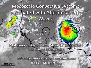
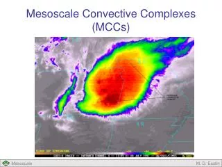
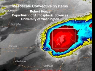
MJO Modulation of Lightning in Mesoscale Convective Systems. Katrina S. Virts and Robert A. Houze, Jr. University of Washington. Seminar, Pacific Northwest National Laboratory, Richland, WA, 4 June 2014. Mesoscale Convective Systems (MCSs).

E N D
MJO Modulation of Lightning inMesoscale Convective Systems Katrina S. Virts andRobert A. Houze, Jr. University of Washington Seminar, Pacific Northwest National Laboratory, Richland, WA, 4 June 2014
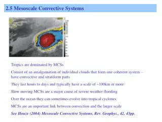
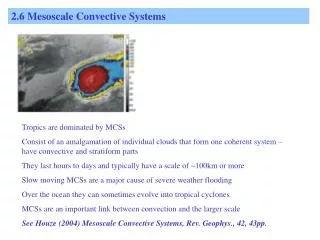
Radar echoes showing the precipitation in the 3 MCSs StratiformPrecipitation ConvectivePrecipitation
Madden-Julian Oscillation • Intraseasonal time scales (~30-80 days) • Enhanced convection develops over equatorial Indian Ocean • Eastward propagation • Associated circulation anomalies Image courtesy Madden and Julian (1972)
MJO modulation of cloud population • Field campaigns (TOGA COARE, DYNAMO/AMIE) • Satellite observations • Passive sensors • “Superclusters” (Nakazawa 1988) • MJO “modulates cloud clusters of all sizes, but larger clusters are proportionately more affected than smaller clusters” (Mapes & Houze 1993) • MJO “associated with weaker or stronger mesoscale organization of deep convection” (Tromeur & Rossow 2010)
MJO modulation of cloud population • Satellite observations (continued) • TRMM • Shallow cumulus and congestus prior to onset of deep convection (Benedict & Randall 2007) • “The precipitating cloud population of the Madden-Julian Oscillation over the Indian and western Pacific Oceans” (Barnes and Houze 2013) • CloudSat • “A familiar evolution of cloud type predominance” (Riley et al. 2011) • “Shallow and congestus clouds in advance of the [MJO] peak, deep clouds near the peak, and upper level anvils after the peak” (Del Genio et al. 2012) • Other A-Train satellites (Yuan and Houze 2013)
MJO modulation of cloud population(Barnes and Houze 2013) • Echo types: • Isolated shallow echoes (ISEs) — echo tops at least 1 km below freezing level • Deep convective cores (DCCs) — radar echo ≥ 30 dBZup to at least 8 km • Wide convective cores (WCCs) — radar echo ≥ 30 dBZ covering at least 800 km2 • Broad stratiform regions (BSRs) — stratiform echo covering at least 50,000 km2
Indian Ocean NW Western Pacific SE Western Pacific Image courtesy Barnes and Houze (2013)
MJO modulation of lightning • Out of phase with rain (Morita et al. 2006) Image courtesy Morita et al. (2006)
MJO active MJO inactive Image courtesy Kodama et al. (2006)
MJO modulation of lightning Break period (phases 8-1-2) minus active period (phases 4-5-6) • Out of phase with rain (Morita et al. 2006) • Suppressed over large islands during active period (Kodama et al. 2006) • Modulation of diurnal cycle (Virts et al. 2013) Image courtesy Virts et al. (2013)
MJO modulation of lightning Break period (phases 8-1-2) minus active period (phases 4-5-6) • Out of phase with rain (Morita et al. 2006) • Suppressed over large islands during active period (Kodama et al. 2006) • Modulation of diurnal cycle (Virts et al. 2013) • What about individual convective clouds? Image courtesy Virts et al. (2013)
Identifying MCSs using A-Train data • MODIS 10.8 m brightness temperature • AMSR-E rain rate • Years included:2007-2010 Details in Yuan and Houze 2010
260K Separated HCS Details in Yuan and Houze 2010
260K Closedcontour Separated HCS Details in Yuan and Houze 2010
260K Closedcontour “HCS” Separated HCS Details in Yuan and Houze 2010
260K Heavy Rain Closedcontour Rain “HCS” Separated HCS Details in Yuan and Houze 2010
260K Heavy Rain Closedcontour Rain “HCS” “Separated” active MCS Separated HCS “Connected” active MCS Details in Yuan and Houze 2010
Global network of 70+ sensors Monitors very low frequency waves Lightning strokes located to within 5 km and a few s Preferentially detects cloud-to-ground lightning World-Wide Lightning Location Network (WWLLN)
Lightning in one-hour window Separate coordinate system for each MCS, centered on largest raining core Lightning in cloudy grid boxes (lightning density) World-Wide Lightning Location Network (WWLLN)
CMCSs most frequent with peak precip. • SMCS timing varies, reflects MJO stage • CMCSs experience greater variability
MJO modulation of lightning inMaritime Continent SMCSs More frequent lightning, broaderlightning maximum during break period
Measure of lower-tropospheric stability Negative LI parcel warmer than environment Calculate using ERA-Interim fields Lifted Index (LI)
MJO modulation of lightning density • Peak lightning at end of break period • SPCZ: peak lightning at beginning of break period • Lower lightning density in CMCSs
TRMM radar precipitation features (RPFs) • Contiguous areas with near-surfacerain rate > 0 • Use features with maximum 30 dBZ height > 6 km • Size equivalent to smallest and largest 50% of MCSs • Years included: 1998-2012 RPF data obtained from University of Utah TRMM database. Details in Liu et al. 2008
TRMM radar precipitation features (RPFs) • Contiguous areas with near-surfacerain rate > 0 • Use features with maximum 30 dBZ height > 6 km • Size equivalent to smallest and largest 50% of MCSs • Years included: 1998-2012 RPF data obtained from University of Utah TRMM database. Details in Liu et al. 2008
MJO modulation of convective rain fraction • Peak at end ofbreak period • Varies strongly withRPF size
Isolated deep convection begins to aggregate Strong instability strong updrafts more lightning Dry mid/upper troposphere smaller stratiform areas MCSs become more numerous Stability increases less lightning Increasingly extensive stratiform rain areas MCSs increasingly more connected CMCS occurrence peaks with precipitation MCSs decrease in number, size, connectedness Smaller stratiform areas rain is more convective Increasing instability during break period more lightning MJO modulation of MCS characteristics
Isolated deep convection begins to aggregate Strong instability strong updrafts more lightning Dry mid/upper troposphere smaller stratiform areas MCSs become more numerous Stability increases less lightning Increasingly extensive stratiform rain areas MCSs increasingly more connected CMCS occurrence peaks with precipitation MCSs decrease in number, size, connectedness Smaller stratiform areas rain is more convective Increasing instability during break period more lightning MJO modulation of MCS characteristics
Isolated deep convection begins to aggregate Strong instability strong updrafts more lightning Dry mid/upper troposphere smaller stratiform areas MCSs become more numerous Stability increases less lightning Increasingly extensive stratiform rain areas MCSs increasingly more connected CMCS occurrence peaks with precipitation MCSs decrease in number, size, connectedness Smaller stratiform areas rain is more convective Increasing instability during break period more lightning MJO modulation of MCS characteristics
Isolated deep convection begins to aggregate Strong instability strong updrafts more lightning Dry mid/upper troposphere smaller stratiform areas MCSs become more numerous Stability increases less lightning Increasingly extensive stratiform rain areas MCSs increasingly more connected CMCS occurrence peaks with precipitation MCSs decrease in number, size, connectedness Smaller stratiform areas rain is more convective Increasing instability during break period more lightning MJO modulation of MCS characteristics
Few MCSs, mainly shallow or isolated deep convection “Younger” MCSs with strong convection “Older” MCSs with mature stratiform rain areas Familiar… MJO modulation of MCS characteristics(simplified)
Similar evolution in 2-4 day wavesduring MJO active period Image courtesy Zuluaga and Houze (2013)
Stretched building block model(Mapes et al. 2006) • Convective clouds and MCSs “in different stages of a large-scale wave have different durations of shallow convective, deep convective, and stratiform anvil stages in their life cycles,” such that evolution of mean characteristics of convective clouds aligns with the evolution of individual clouds.
Conclusions • MCSs over land contain more vigorous convection, more lightning • MCSs over the ocean are more connected • Larger, more connected, and more numerous MCSs during MJO active period • Peak lightning and convective rain fraction just prior to active period (except over SPCZ) • Evolution of mean MCS characteristics aligns with MCS lifecycle (stretched building block)
This work was funded by NASA (# NNX13AQ37G)and the Department of Energy (#DE-SC0008452).