Download
1 / 33
340 likes | 517 Views
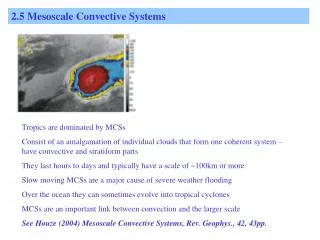
2.6 Mesoscale Convective Systems. Tropics are dominated by MCSs Consist of an amalgamation of individual clouds that form one coherent system – have convective and stratiform parts They last hours to days and typically have a scale of ~100km or more

E N D
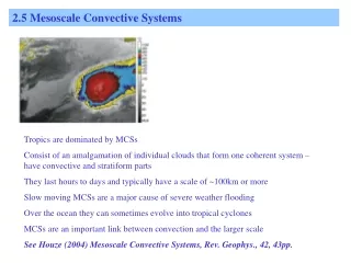
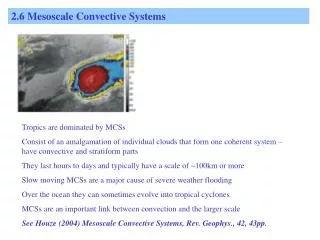
2.6 Mesoscale Convective Systems Tropics are dominated by MCSs Consist of an amalgamation of individual clouds that form one coherent system – have convective and stratiform parts They last hours to days and typically have a scale of ~100km or more Slow moving MCSs are a major cause of severe weather flooding Over the ocean they can sometimes evolve into tropical cyclones MCSs are an important link between convection and the larger scale See Houze (2004) Mesoscale Convective Systems, Rev. Geophys., 42, 43pp.
2.6 Mesoscale Convective Systems 3 stages of common convective showers “Disorganized convection lasts ~0.5-2 hours”
2.6.1 What is an MCS? An MCS can be defined as a cloud system consisting of an ensemble of convective storms and producing a contiguous precipitation area of horizontal scale 100km or more, in at least one direction (Houze, 1993). This definition includes squall lines and MCCs.
2.6.1 What is an MCS? MCSs characterized by convective (~10%) and stratiform rain Typically move westwards at ~10-20m/s Last hours to days
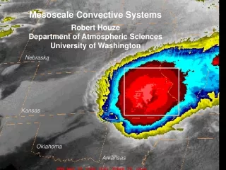
2.6.1 What is an MCS? Example of an African squall line observed in COPT81 (Ivory Coast) seen from radar.
2.6.1 What is an MCS? Figure from TOGA-COARE IOP reminds us of the large variations in scale and longevity Recall that MCCs represent a problem for NWP (resolved and parametrized) See Moncrief and Klinker (1996)
2.6.1 What is an MCS? How come MCSs can live for days when storms only last a few hours? Convection needs to be organised! Organised in this sense means that the downdraft is displaced relative to the updraft, so that updraft is not “killed”.
2.6.1 What is an MCS? Conceptual Model of Mature Stage Houze et al , 1989 BAMS p608-619 In the convective part, streamlines indicate general upward motion, starting in the boundary layer and extending up through the convective region – and sloping into the upper stratiform rain region A general trend of downward motion is schematisized in the lower part of the stratiform region and is associated with a rear inflow. At the early stages the stratiform is not present, in the decaying stage the convective part is not present.
2.6.1 What is an MCS? Conceptual Model of Mature Stage • MCSs generally propagate with respect to the winds at most levels • gust front – leading edge of advancing rain-cooled air near the surface • a line of convective cells – air from near the surface ascends through troposphere; also produce sharp small-scale downdrafts • a broad anvil cloud observed to ascend at velocities of 1 to 2m/s • a mesoscale downdraft, likely produced by evaporation and melting of hydrometeors below the anvil
2.6.1 What is an MCS? Showing updraft and downdraft speeds etc from COPT81 experiment Maximum updraft speeds of 13m/s occur at 2.5km Behind leading edge of the line downdrafts with peaks of 4m/s.
2.6.1 What is an MCS? Conceptual Model of Mature Stage • Sometimes a strong jet-like downdraft, referred to as the “rear-inflow jet” appears underneath the anvil sloping downward toward the front of the system. • Note also that updraft cells move backwards as they mature – cloud debris of decaying cells forms the stratiform cloud mass anvil
2.6.1 What is an MCS? Conceptual Model of Mature Stage • The action of the MCS is to transport high thetae from the boundary layer upwards and low thetae from mid-levels downwards
2.6.1 What is an MCS? Conceptual Model of Mature Stage • Broadly speaking ingredients needed for MCS are: • Large CAPE (high boundary layer thetae) • Significant vertical shear in the lower troposphere normal to the MCS (acts to retard the gust front and keep it in phase with the developing convective clouds) • Source of downdraft air (low mid-level thetae)
2.6.1 What is an MCS? Radar echos highlight convective and stratiform rainfall regions There is often a radar reflectivity minimum separating strong convective cells from the broad region of anvil associated ppn
2.6.1 What is an MCS? A radar “bright band” may be seen near the freezing level in the stratiform ppn region – due to radar reflectivity of melted snow which is very high. Above image is taken from TRMM (Schumacher and Houze, 2006)
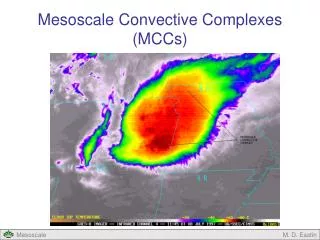
2.6.2 Where do MCSs occur? Mesoscale Convective Complexes (MCCs) – long-lasting, quasi-circular extremely cold topped MCS (Maddox, 1980) Mainly occur over land (larger CAPE) Maintained against nocturnal stablization (strong shear, strong dynamics (Mesoscale Convective Vortex (MCV))
2.6.2 Where do MCSs occur? Most frequent occurrence of lightning is over tropical land regions. Tropical Africa most active (why?). Most lightning will be associated with MCSs.
2.6.2 Where do MCSs occur? Continental MCSs exhibit strong ice-scattering close to regions of strongest lightning activity Note strong contasts between Africa and tropical Atlantic downstream
2.6.2 Where do MCSs occur? Note the stronger stratiform rain fractions over the ocean (why?) Atlantic ITCZ (>40%) Tropical Africa (20-30%) (why?) Stratiform regions are deep ice clouds from ~5km to the tropopause – Figure suggests more ice cloud over ocean than land. (cf previous figure; see Houze 2004 for more discussion) Pacific ITCZ has highest stratiform rain fraction in the tropics (>60%) Such variations in Stratiform-Convective ratios affects the mean heating profiles and have consequences for the large-scale atmospheric dynamics.
2.6 Mesoscale Convective Systems (summary so far) 2.6.1 What is an MCS? An amalgamation of clouds characterised by a deep convective leading edge and a trailing stratiform region. They last from hours to days, have typical scales of at least 100km in one direction and propagate with a speed between 10 and 20m/s. 2.6.2 Where do MCSs occur? Everywhere in the tropics Most intense MCSs occur over tropical continents There is more ice scattering over land but less stratiform rainfall
2.6 Mesoscale Convective Systems NEXT: 2.6.3 Balanced Circulations (MCVs)
Divergent and Balanced Circulations – Two ways to view MCSs!
Divergent Circulations!!! Zipser (1977) produced a conceptual model that blended parcel thinking with the layer model. Environmental air approaches the MCS with Moncrieff-type ascending layer trajectories; but when the air saturates, parcel processes become active in a “crossover” zone – where unstable ascent and lateral entrainment occur Air entering at mid-levels will have such low thetae that it will sink. This model has been discussed and modified in subsequent papers – see Houze review.
2.6.3 Balanced Circulations See animation Note presence of significant mesoscale circulations in the presence of the convection – even after convective activity has weakened. Note that convection can go through active and inactive periods – presumably linked to the diurnal cycle.
2.6.3 Balanced Circulations Recall that vertical gradients in heating impact the redistribution of PV. In particular we expect there to be +ve PV generation at mid-levels in the stratiform rain region.
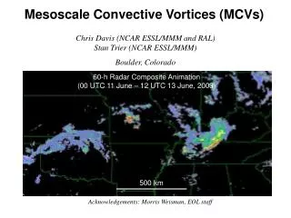
2.6.3 Balanced Circulations The formation of a mesoscale vortex in the stratiform region was first noticed in the tropics – but they are also very prominent in midlatitudes. These have become known as “ Mesoscale Convective Vortices” or MCVs.
2.6.3 Balanced Circulations Hertenstein and Schubert (1991) : Potential Vorticity Anomalies Associated with Squall lines, MWR, 1663-1672 They compare the PV structures of two midlatitude squall lines – one with and one without a trailing stratiform region.
2.6.3 Balanced Circulations The nature (intensity, scale) of the MCV is strongly influenced by the heating profile It is therefore important to know about the relative contributions from deep (and shallow) convection, and stratiform rain in MCSs. This depends where you are in the tropics and also within the season. See Schumacher and Houze (2006) QJRMS 2235-2255 for class discussion