Download
1 / 10
100 likes | 188 Views
Explore innovative groundwater modeling techniques utilizing the MDEQ database in Augusta Creek Watershed. Learn about Three closely related projects, NSF-IGP, MDEQ Mapping, IGW-MDEQ Database Interface, and more. Valuable data on Oil/Gas Wells, Lakes, Water Wells, Streams, and Trout streams. Detailed analyses of water level dynamics and drawdown cones over different decades. Discover the accuracy of the Wellogic SWL matched with standard water level measurements.

E N D
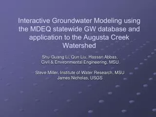
Interactive Groundwater Modeling using the MDEQ statewide GW database and application to the Augusta Creek Watershed Shu-Guang Li, Qun Liu, Hassan Abbas, Civil & Environmental Engineering, MSU Steve Miller, Institute of Water Research, MSU James Nicholas, USGS
Three Closely Related Projects • NSF - Interactive Groundwater Project, PIs: Li, Liu, since 1997 • MDEQ - Statewide Groundwater Mapping Project, PIs: Lusch, Reeves, Miller • MDEQ – The IGW-MDEQ Database Interface Project. PIs: Li and Liu
Based flows Oil/Gas Wells Lakes Recharge Water Wells Lakes Streams MDEQ Statewide Groundwater Database Trout streams Trout streams/lakes
Wellogic data Field data
CLARE Field data KA Wellogic DATA KA Field DATA CLARE Wellogic DATA LIVINGSTON Field DATA LIVINGSTON Wellogic DATA If processed properly, the wellogic SWL matches very well with standard water level measurements
Additional Evidence showing the wellogic SWLs are very valuable Ionia county 1 Kent county Ionia county 2 Augusta The orientation of WHPAs based on field data matches well with the direction of head gradient estimated from the Wellogic data Kalamazoo county City of Clare Washtenaw County Branch county
Lansing Drawdown Cone Dynamics 60’s: 856pts; 740ft to 894ft 70’s: 1774pts; 722ft to 908ft 80’s: 1552pts; 740ft to 892ft 90’s: 894pts; 776ft to 901ft 00’s: 1053pts; 769ft to 890ft Avg: 6278pts; 748ft to 910ft