Urban Models
Learn how Chicago's urban ecology was explained using the Burgess Concentric Model in the 1920s, based on empirical research in American cities. The model highlights concepts of competition, dominance, invasion, and succession in urban development.

Urban Models
E N D
Presentation Transcript
Concentric model • It was put forward by Ernest W. Burgess (sociologist) and his associates in 1920s. • It was based on empirical research in a number of American cities, like Chicago.
Concepts of the model • Burgess adopted the concepts used by plant ecologists (ideas of competition, dominance, invasion and succession) • within the city, people competes for limited space (COMPETITION) • those who are best able to pay (DOMINANCE) achieve the most desirable locations (INVASION and SUCCESSION). • those individuals and functions with the lowest level of economic competence have the least choice, occupying the poorest locations.
How did Chicago school explain the city using urban ecology? 1. Each zone in space represented a distinct level in the moral order Level in the moral hierarchy Distance from the CBD
For any given time, each ethnic group had its peculiar geographical niche – its “natural place.” • Change in location of a group explained by “invasion and succession.”
Invasion and succession • This is caused by growth of city economy & arrival of new migrants to the city. • As the city grew, the CBD would exert pressure on the zone immediately surrounding it i.e. the zone of transition • Outward expansion of the CBD would invade nearby residential areas causing them to expand outwards. • The process was thought to continue with each successive neighbourhood moving further from the CBD. • New immigrants would move into the cheapest residential areas of the city. When they became economically established, they would migrate outwards. • Thus lower residential class moved to adjacent neighbourhoods and more affluent residents moved further outwards.
Bid-rent mechanism • land value decreases with increasing distance. • the highest land value is at the city centre because of keenest competition.
functional zoning and residential segregation • = within different areas of the city, different single functions formed the dominant element.
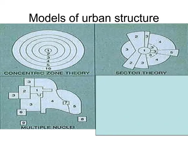
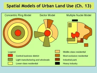
C.B.D. Transition Zone Low class residential Middle class residential Commuter’s zone Concentric Model
CBD • at the heart of the city • forms the commercial, social and cultural hub. • the most accessible, at the focus of urban transport network
Chicago’s inner city “slums” 1920s Chicago’s Gold Coast 1930s
Zone in transition • Surrounds the CBD • an area of ‘blight’, also called the twilight zone. • An area of mixed land uses– wholesale, light manufacturing, residential • Provides cheap housing for each new immigrant wave • the zone often characterized by slums, immigrant ghettoes, unstable and low social groups and crime. • poorest residential areas.
Zone of workingmen’s homes • surrounds the transition zone • has some of the older, often terraced housing areas of the city • occupied by workers who have left the transition zone but who still require ready access to their places of work in the inner zone. They left transition zone because they want better living conditions. • 2nd generation immigrants form an important element of the pop. in this zone.
Zone of better residence (middle-class housing) • usually single-family dwellings in semi-detached or detached houses • also some light industry in this zone, often in industrial estates.
Commuter Zone • lies beyond the continuous built-up area of the town, at the fringe of the urban area. • consists of discontinuous urban settlement interspersed with recreational facilities, woodland, pastures. • is the zone of high class residential properties where people can afford the high costs of commuting.
Major features of the model • Positive correlation of socio-economic status of households with distance from the CBD. • The more affluent households live at greater distance from the central city. • The lower-status groups are to be found near the city centre and the high-status groups at its periphery
Major features of the model • Some districts are culturally distinct and are occupied by people of similar race, language and socio-economic status. • The idealized concentric zones would be modified by opposing factors like relief, micro-climate and distribution of industries.
Early stage of urbanization • People tended to reside near the CBD to minimize the distance travelled so as the transport cost
As real incomes have risen and better transportation has increased mobility, this allows the separation of home and workplaces. Wealthy people moved out of the inner city which was later Invaded by poorer ethnic minorities due to rising immigrants to the city. To offset high land value in these near-city locations, they use only small amount of land by living in high density apartments which make maximum use of expensive land. Occupied by wealthier people who could afford the higher transport cost when moving out of the city centre. Wealthy people can occupy larger amount of cheaper residential land on the periphery where they live in detached dwellings and pay the high commuting costs to city centre. suburbanization
Results of suburbanization • social segregation = creating particular groups or classes which segregate themselves from other groups. • poor people living close to the city centre on high value land, while more wealthy people live on the periphery where land is generally cheaper. • As reflected by the quality of housing • different in life styles + quality of life, income and social status
Criticisms • The model considers ground floor functions only, and little attention is paid to the height of buildings and vertical variations of function. • The model suggests that there are sharp boundaries between the functional zones. In reality these abrupt changes do not occur.
Criticisms • Concentric zones are not homogenous but heterogeneous • therefore, they are not distinctive and inevitably distorted by major transport axes and topography features.
Criticisms • Limited universality: it is limited “to a particular situation, at a particular time in a particular country” (Carter, 1976) • The setting of the model was based on a particular historical & cultural context. • It is most relevant to American cities in the 1920s but is less relevant to other times and other cities especially in ELDCs.
The decline of the CBD and the emergence of suburban business centres Increasing level of public intervention Transport innovation it has allowed many centres of employment to grow outside the CBD due to increased mobility large plots of land are only available in the urban fringe, thus lower class residential areas are found in the outer zone where high class residential areas are. It enables low class residents to move away from their place of work. Criticisms
Criticisms • Use for understanding residential pattern better than commercial and industrial land uses
Contributions • It was the first attempt to analyse theinternal morphologyof town • Burgess model has invaluable contribution for residential land use of a city. It suggests a process of urban growth that might give rise to these. • It provides a good conceptual framework for more detailed study of the complex urban land use.