Download
1 / 14
140 likes | 547 Views
Urban Land Models. AP Human Geography. What do we always say about models?. Most importantly – they are just models Models only represent patterns in space The landscape does NOT look exactly like the model Models are thus representations of the landscape to help better understand patterns.

E N D
Urban Land Models AP Human Geography
What do we always say about models? • Most importantly – they are just models • Models only represent patterns in space • The landscape does NOT look exactly like the model • Models are thus representations of the landscape to help better understand patterns
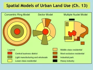
Three Classic Urban Models • Other Urban Models
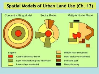
Burgess Concentric Zone Modelhttp://www.lgfl.net/lgfl/leas/barnet/accounts/migration/web/Land%20Use/documents/burgess-re-done.jpg
Characteristics of Concentric Zoneen.wikipedia.org/wiki/Ernest_Burgess • Burgess studied 1920s Chicago to make this model • 5 concentric zones • Burgess suggested that immigrants lived in inner zones which caused affluent residents to move further out • Concentric Zone’s weakness is that it does not allow for change in the city • Concentric Zone does not allow for physical geographic barriers
Hoyt Sector Model • Late 1930s • Answered the drawbacks of Burgess Model • Hoyt said growth created pie-shaped urban structure • Hoyt said his pie-shaped zones could reach from the Core (CBD) to the edge of the city (e.g. low rent sector 3 from CBD to outskirt of city) • Sector Model says that the CBD is not as important as Burgess indicated • Sectors were developed along transport routes (e.g. highways, RRs, etc.)
Harris & Ullman – Multiple Nucleihttp://teacherweb.ftl.pinecrest.edu/snyderd/APHG
Multiple Nuclei • 1940s • Harris & Ullman hypothesized the CBD was further losing its dominance • CBD no longer the nucleus of the modern city, thus emergence of ‘nuclei’ • Reflects decentralization and nucleation of urban functions • Nuclei are disconnected and do not necessarily rely on each other
Urban Realms Modelwww.csiss.org • Hartshorn and Mueller • 1980s • Modeled after cities like Atlanta and Los Angeles • Further metamorphosis of multiple nuclei
World Urban Modelswww.macalester.edu/.../amartin/urbanstruct.htmlwww.macalester.edu/.../tsadowy/Jabotek.html