Hierarchical Model of Near-Surface Geologic Environments and Hydrologic Flow Systems
130 likes | 257 Views
This work explores a hierarchical model of near-surface geologic environments, delving into the intricate components such as hydrology, mineralogy, and organic matter. It examines how hydrologic flow regimes influence pollutant fate and chemical equilibrium in subsurface environments. Key features include analysis of both unsaturated and saturated zones, highlighting their impact on contaminant movement and biological activity. The study enhances understanding of watershed dynamics by integrating soil type, bedrock geology, and water chemistry into geologic systems.

Hierarchical Model of Near-Surface Geologic Environments and Hydrologic Flow Systems
E N D
Presentation Transcript
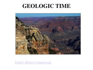
Near-surface Geologic Environments Bruce Herbert Geology & Geophysics
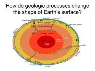
Hierarchy model of Landscapes • Descriptions start at small scales • Describe flow between these systems • Describe spatial and temporal variation at higher scale
Components of Near-surface Environments Important Components • Hydrology • Sediment & rock mineralogy • Organic matter • Gaseous composition • Aqueous chemistry • Morphology & Structure There is a strong correlation between hydrology and composition & structure. WHY?
Hydrologic Flow Regimes • The hydrology of the subsurface environment in part determines the fate of pollutants. • The rate of water flow affects the attainment of chemical equilibrium by the subsurface geochemical processes. • Hydrologic flow paths also determine the type of solid surfaces that can interact with dissolved compounds. • The most fundamental distinction between hydrologic regimes is the differences between the unsaturated and saturated zones
Components of Landscape Prisms Landscape Prism • Mineralogy • Soil & ground water chemistry • Organic matter composition • Composition of soil gases • Microbial ecology For a landscape prism, we are typically interested in:
Soils and Regoliths Unsaturated zone: pore spaces are filled with gases and water • Water is under negative hydraulic pressure. • Recharge water has high concentrations of O2 and CO2 • Solid phase is dominated by unconsolidated sediment and organic matter • Soil are biologically active because of the large inputs of plant debris to these systems. • Flow of contaminants to groundwater usually passes through unsaturated zone first. Upward movement of water by capillarity in glass tubes of different diameter and capillarity in soils.
Saturated Zones • Saturated zone: pore spaces are filled with water. • Boundary between the saturated and unsaturated zone is the capillary fringe. • Groundwater, lake and estuary, wetlands. • Porosity can vary between 0 to 60% • Organic carbon is usually less than 2% except for shales, lignites or other C rich zones. • Much lower biological activity in this zone compared to the unsaturated zone. • Solid phase can be consolidated rock or unconsolidated sediment
Saturated Zones: Flow Systems • A hydrologic flow system is a subsurface region where hydrologic flow lines remain adjacent throughout the region • Local flow systems • Intermediate flow systems • Regional flow systems
Saturated Zones: Local Flow Systems • The recharge area at a topographic high and the discharge area at a topographic low are adjacent. • Hydrologically active: residence times of water are on the order of days to years. • These systems are relatively open in respect to nutrients and O2. This makes them biologically active. • Roughly 80 to 90% of all ground water contamination events are in local flow systems.
Saturated Zones: Intermediate Flow Systems • Recharge and discharge areas are separated by one or more topographic highs. • These aquifers produce a high percentage of GW used for human consumption. • Much lower biological activity due to lower amounts of O2 and nutrients.
Saturated Zones: Regional Flow Systems • Recharge area occupies the water divide and the discharge area occurs at the bottom of the basin. • Ground water has a long residence time. Typically the water has a high salt content. • Some anaerobic microbial activity
Watersheds as Geologic Systems For a drainage basin, we are typically interested in: Texas Watersheds • Soil type & bedrock geology • Surface & ground water chemistry • Basin hydrology • Sediment composition • Fluvial landforms • Channel morphology