Download
1 / 6
60 likes | 159 Views
Collecting data for a geologic map and cross-section of Paleozoic and Mesozoic units, with structural data on folding effects and modern deposits in Crook Creek, SD area.

E N D
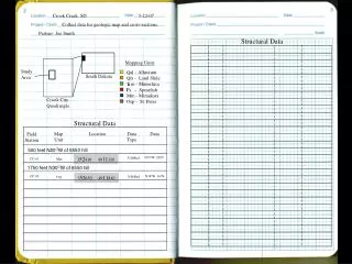
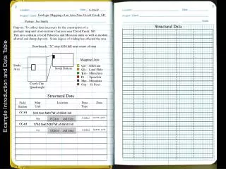
5-22-07 Geologic Mapping of an Area Near Crook Creek, SD Partner: Joe Smith Structural Data Purpose: To collect data necessary for the construction of a geologic map and cross-section of an area near Crook Creek, SD. This area contains several Paleozoic and Mesozoic units as well as modernalluvial and slump deposits. Some degree of folding has effected the area. Benchmark: “X” atop 6550 hill near center of map Mapping Units Study Area Qal - Alluvium Qls - Land Slide T m - Minnelusa Ps - Spearfish Mm - Minnikata Osp - St. Peter South Dakota R Crook City Quadrangle Example Introduction and Data Table Structural Data Map Unit Location Data Type Data Field Station CC-01 500 feet N20OW of 6550 hill N35oW, 20oN 352410 4911320 S-D/Bed Mm CC-03 1750 feet N30OW of 6550 hill N38oW, 16oN 352650 4911810 S-D/Bed Osp
Day 1 of 3 5-22-07 Weather: sunny ~65o. Continuing ~east toward main north-south drainage valley. Should Location: Parked vans near the two houses at the extreme north east edge of the mapping area. We will head ~ east on the dirt road. This road is labeled as a single dashed line. find exposure of older St. Peter Ss in valley. 1550 feet N35oW of BM CC-02 20’ down into the valley at about the 1400’ contour line, Purpose: Working mostly the north 3 kilometers trying to ID major mapping units and collecting structural data. the soil becomes sandy. There is an outcrop of sandstone about another 30’ below. Looks like a good place for S-D. CC-03 1750 feet N30oW of BM Outcrop of (St. Peter Ss). Nick point which exposes about 15 vertical feet over a length 500 feet N20oW BM there is an expose of CC-01 S-D/Bed of 10’ at the bottom and narrowing to about 5 feet at the top. Limestone along the northern side of the road. The outcrop N38oW, 16oN There are tangentially truncated cross-beds which range in S-D/Bed is about 25’ long, 4‘ high in the middle, and tapers down at thickness from 1.5’ to 2.0’ with the thinner beds near the top. Example Field Notes for Geologic Mapping N35oW, 20oN both ends. Bedding is thin, 1.5” – 2.5” and dipping The upper most bed is oxidized dark brown and provides a resistant ledge. Slightly to the north. The beds thicken with height. Rock Description: St Peter Ss Well rndd, well srtd, med. grnd, calcareous Q-arenite. Rock Description: Fossiliferous Biomicrite Weathered surface is med. brn, fresh is light yellow. All Lt. brn. on weathered surface, med. gray on fresh. Fossils grains are frosted. of crinoids and brachiopods account for 5-10% of the rock N S and are matrix supported. This is the (Minnikata Formation) Stratigraphic Column of St. Peter Ss “Cross-section along dirt road showing exposure of Minnikata limestone” exposure near valley bottom E W 15’ 4’ 25’ Note: Beds thicken higher in this outcrop.