Download
1 / 1
10 likes | 113 Views
This study compares radar altimetry from Topex/Poseidon and ENVISAT RA-2, laser altimetry from ICESat, GPS measurements, and hydrological modeling to estimate river slopes in the Negro River basin within the Amazon basin. The basin's extension, tributary status, and water characteristics are analyzed to understand flood wave propagation, sediment transport, and discharge estimation challenges.

E N D
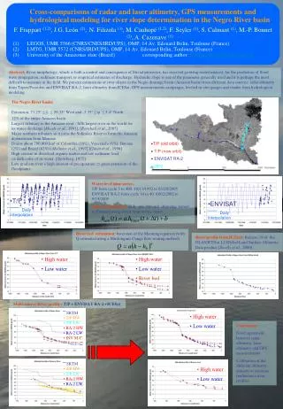
Water level time series: T/P from cycle 3 to 460 10/13/1992 to 03/20/2005 ENVISAT RA-2 from cycle 10 to 40 10/02/2002 to 9/19/2005 Daily interpolation: daily series at each altimetric station is obtained using closer limnimetric series: •T/P Daily interpolation •ENVISAT Daily interpolation River bed estimation: Inversion of the Manning equation (with Q estimated using a Muskingum-Cunge flow routing method) SRTM• T/P HW• T/P LW• RA-2 HW• RA-2 LW• GPS SRTM• T/P HW• T/P LW• RA-2 HW• RA-2 LW• INV M-C • Cross-comparisons of radar and laser altimetry, GPS measurements and hydrological modeling for river slope determination in the Negro River basin • F. Frappart (1,2), J.G. León(2),N. Filizola (3), M. Cauhopé (1,2), F. Seyler (1), S. Calmant (1), M.-P. Bonnet (2), A. Cazenave (1) • LEGOS, UMR 5566 (CNRS/CNES/IRD/UPS), OMP, 14 Av. Edouard Belin, Toulouse (France) • LMTG, UMR 5572 (CNRS/IRD/UPS), OMP, 14 Av. Edouard Belin, Toulouse (France) • University of the Amazonas state (Brazil) corresponding author: frederic.rappart@legos.cnes.fr Abstract:River morphology, which is both a control and consequence of fluvial processes, has received growing recent interest, for the prediction of flood wave propagation, sediment transport, or empirical estimates of discharge. Hydraulic slope is one of the parameter generally used and it is perhaps the most difficult to measure in the field. We present estimations of river slopes in the Negro drainage basin (Amazon basin) from different data sources: radar altimetry from Topex/Poseidon and ENVISAT RA-2, laser altimetry from ICESat, GPS measurements campaigns, leveled in-situ gauges and results from hydrological modeling. The Negro River basin:Extension: 73.25° ≤ ≤ 59.35° West and -3.35° ≤ ≤5.4° North12% of the entire Amazon basin Largest tributary to the Amazon river : fifth largest river in the world forits water discharge [Meade et al., 1991], [Ronchail et al., 2005] Major northern tributary as it joins the Solimões River to form the Amazon downstream from Manaus Drains about 700,000 km² of Colombia (10%), Venezuela (6%), Guyana (2%) and Brazil (82%) [Molinier et al., 1997] [Guyot et al., 1998] High content in dissolved organic matter and low sediment loaddark color of its water [Sternberg, 1975] Low gradient river + high amount of precipitation great extension of thefloodplains. • T/P (old orbit) • T/P (new orbit) • ENVISAT RA-2 • GPS River profile from ICESat: Release 19 of the GLAS/ICESat L2 Global Land Surface Altimetry Data product [Zwally et al., 2000] • High water • Low water • High water • Low water • River bed Multi-source River profile : T/P + ENVISAT RA-2 +ICESat • High water • Low water Conclusion: Good agreement between radar altimetry, laser altimetry and GPS measurements Calibration of the different altimetry datasets to estimate multisource river profiles • High water • Low water