Download
1 / 17
170 likes | 344 Views
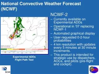
Use of TAMDAR Data in a Convective Weather Event. Saturday, May 21, 2005. Background Information. TAMDAR was used by meteorologists at the NWS office in Sioux Falls, South Dakota during an expected convective event on May 21, 2005.

E N D
Use of TAMDAR Data in a Convective Weather Event Saturday, May 21, 2005
Background Information • TAMDAR was used by meteorologists at the NWS office in Sioux Falls, South Dakota during an expected convective event on May 21, 2005. • Model soundings suggested that a mid level cap would erode during the late afternoon, resulting in strong or severe thunderstorms. • The Storm Prediction Center (SPC) had this area in a Convective Outlook, and later issued a Tornado Watch.
Background Information • Sioux Falls forecasters looked at TAMDAR soundings from Sioux City, Iowa during the late afternoon and early evening hours. • The soundings showed a mid level cap that would be nearly impossible to overcome by expected surface heating. Therefore, they lowered the probability of thunderstorms in their local forecasts. • Based upon the observation that the cap would be too strong to overcome, they coordinated with SPC to leave six of their counties out of the tornado watch. No severe weather occurred in those counties.
Sioux Falls Forecast Area The Sioux Falls NWS is responsible for severe weather warnings for these counties
Surface Map 12Z5/21/2005 A surface low was moving east towards Minnesota. The eastern Dakotas, western Minnesota, eastern Nebraska and western Iowa were forecast to be in the warm sector in the late afternoon. 12Z Model forecast soundings suggested mid level cap would be overcome in the late afternoon, with Capes of 2-3,000 J/kg and significant shear
SPC Day 1 Outlook • SPC correctly identified the significant cap over the Plains states in this 1630UTC update. • Models forecast cap to be overcome by strong surface heating and mid level cooling in the late afternoon. • CAPE and shear profiles from models suggested that thunderstorms that resulted could be severe.
SPC Day 1 Outlook DAY 1 CONVECTIVE OUTLOOK NWS STORM PREDICTION CENTER NORMAN OK1120 AM CDT SAT MAY 21 2005 VALID 211630Z - 221200Z...NE/IA/KS/MO... MORNING SOUNDINGS CONFIRM THAT A SUBSTANTIAL CAP CURRENTLY ACROSSTHE PLAINS AS ELEVATED MIX LAYER HAS SPREAD EWD OVERNIGHT WITH VERYSTEEP MID LEVEL LAPSE RATES. 50KT LOW LEVEL JET AHEAD OF COLD FRONTWILL RAPIDLY INCREASE LOW LEVEL MOISTURE NWD THRU CENTRAL PLAINSTHIS AFTERNOON. WHILE NAM SEEMS A LITTLE AGGRESSIVE ON MOISTURETRANSPORT... GIVEN THE OBSERVED DEWPOINTS RISING THRU THE 60S FACROSS CENTRAL KS...SUBSTANTIAL DESTABILIZATION IS EXPECTED AHEAD OFCOLD FRONT BY MID/LATE AFTN AS FAR N AS ERN NEB/WRN IA. EROSION OF THE EXISTING STRONG CAP WILL TAKE PLACE THIS AFTERNOONTHRU STRONG SURFACE HEATING AND LARGE SCALE VERTICAL MOTION AHEAD OFFRONT AND APPROACHING UPPER TROUGH. BY LATE AFTERNOON WITH MLCAPES BETWEEN 2000-3000 J/KG COUPLED…
Radar and satellite data at 18Z • 18Z radar from Omaha showed scattered showers over northern and central Iowa. • An 18Z satellite picture showed clear skies over western Iowa and the eastern Dakotas, except for developing cumulus. • These cumulus were expected to develop into thunderstorms as the cap was broken.
Radar from Omaha at 18Z Radar shows scattered showers over northern and central Iowa at 1800Z. Eastern Nebraska and Southwest Iowa are currently free of echoes.
Visible satellite picture at 18Z Visible satellite picture from 18Z shows some cumulus clouds forming over the eastern Dakotas, eastern Nebraska and western Iowa. These clouds will later have little vertical extent due to the mid level capping inversion
A Waiting Game… • Now NWS WFOs in the outlook area must wait and see whether mid level cap over the Iowa, Minnesota and eastern Nebraska can be broken. • Until recently, forecasters had no real time way of assessing cap strength • TAMDAR and MDCRS data are now available, and can help meteorologists determine convective potential in real time.
TAMDAR data 19Z-22Z Map showing flight paths of TAMDAR equipped aircraft 19-22Z May 21, 2005. From FSL Aircraft Web Page http://acweb.fsl.noaa.gov/java
This TAMDAR sounding from Sioux City at 1940Z shows strong directional and speed wind shear, but a mid level capping inversion that would prevent severe thunderstorms from forming.
Results • Forecasters at the Sioux Falls office viewed the TAMDAR data in the NSHARP program to further refine the convective potential. • They determined that the cap would not likely be overcome, despite model forecasts suggesting it would. Therefore, they lowered the probability of thunderstorms in their local forecasts. • They also coordinated with SPC to leave six of their counties out of a tornado watch that was issued.
Tornado Watch Issued The Sioux Falls NWS asked the Storm Prediction Center to leave six counties of their forecast area out of a Tornado Watch that was issued during the late afternoon. The SPC agreed, and no severe weather occurred in those counties.
Preliminary severe weather reports May 21, 2005 The lack of severe weather reports from the tornado watch area shows that the mid level inversion was indeed too strong to get severe weather.
Summary • TAMDAR was useful in showing that the model soundings were incorrect in forecasting the mid level cap to be broken. • Sioux Falls and SPC meteorologists were able to improve their forecasts by leaving parts of South Dakota and Iowa out of the Tornado Watch. • Other WFOs may have been able to improve their forecasts if they had used the TAMDAR data.