Download
1 / 17
180 likes | 348 Views
National Convective Weather Forecast (NCWF). Stan Trier, NCAR (trier@ucar.edu). 1) Description and Examples of NCWF. 2) Related Ongoing and Future Developments. - NCAR Autonowcaster ( J. Wilson, R. Roberts, T. Saxen, H. Cai, E. Nelson, D. Albo, S. Dettling, N. Oien ).

E N D
National Convective Weather Forecast (NCWF) Stan Trier, NCAR (trier@ucar.edu) 1) Description and Examples of NCWF 2) Related Ongoing and Future Developments - NCAR Autonowcaster (J. Wilson, R. Roberts, T. Saxen, H. Cai, E. Nelson, D. Albo, S. Dettling, N. Oien) - Numerical Forecast Models (e.g., WRF) / Observations and Model Blending Collaborators: C. Mueller, J. Pinto, D. Ahijevych, D. Megenhardt, N. Rehak
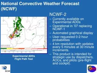
National Convective Weather Forecast (NCWF) NCWF -1 NCWF-2 • 1-2 hr probability forecasts • Capture regions of growth • Trend dissipation • 1 hr Extrapolation (cyan) • Binary yes/no • Operational Product • http://adds.aviationweather.gov/convection • 1 & 2 hr Probability Forecasts • Improved Motion Vectors • Growth & Decay • Experimental Product • http://weather.aero/convection
NCWF Processing Convective Hazard Detection Data: Radar (VIL) mosaics Echo-tops mosaics Lightning (NLDN) 20km RUC Nowcast Motion Vectors Probability Large-scale Trending RUC Large-scale Growth Color Key: Standard (NCWF 1 & 2) AWC Forecaster Display Verification Aviation User Display (Ex. ADDS) New (NCWF 2 only)
NCWF-1 on Operational ADDS http://adds.aviationweather.gov
NCWF-1 on Operational ADDS http://adds.aviationweather.gov
Previous (Current) 1-hour Hazard Forecast in Purple (Blue) Polygons
National Convective Weather Forecast (NCWF) T= 0 min NCWF-2(hr) • Currently available WWW • 4 km updates every 5 minutes. • Use by dispatchers, AOCs, and pilots (pre-flight). • Probabilities based on spatial coverage: area size increasing with time • Trending and growth based on NWP NCWF-6(hr) • Blended observation and RUC based system +30 min +60 min +90 min +120 min Experimental ADDs Flight Path Tool Darker to lighter shades of pink : Higher to lower Probabilities
Product Availability • Experimental ADDS NCWD2 Growth/Decay 2 Hour Forecast 1Hour Forecast
Convective Hazard Detection / 1-hr Forecast Probabilities (Pink Shades)
The Auto-Nowcaster System is unique in its ability to providenowcasts of storm initiationby….. Detection and extrapolation of surface convergence boundaries …. ….that trigger thunderstorm initiation and impact storm evolution.
Initiation nowcasts extrapolation nowcasts Example of Auto-Nowcaster Initiation Forecast 1 hour forecast Verification
Where has the Auto-nowcaster been demonstrated ? • Weather Forecast Office Washington DC (Sterling, VA) • Sydney Australia Forecast Office • U. S. Army White Sands Missile Range • Central U. S. for the FAA Process of being transferred to: • Bureau Meteorology Beijing China • U.S National Weather Service – Dallas/Fort Worth Weather Forecast Office • AWIPS
24 h Reflectivity Forecast valid 4-30-05 00Z 4 km WRF-ARW 4 km WRF-NMM 2 km WRF-ARW Radar
Statistical Evaluation Validation Period : 01-14 Aug 2005 Comparing NCWF05-05, RCPF50-05, Merged05-05 NCWF Merged RUC Validation Region
Previous 1-hour Growth (Forecast Growth) and Decay of Convective Hazard
Convective Hazard Detection / Previous 1-h Forecast Validation (Purple Polygons)