Download
1 / 14
140 likes | 268 Views
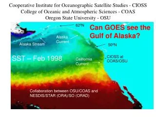
Cooperative Institute for Oceanographic Satellite Studies - CIOSS College of Oceanic and Atmospheric Sciences - COAS Oregon State University - OSU. 62 ºN. Can GOES see the Gulf of Alaska?. Alaska Current. Alaska Stream. 50 ºN. SST – Feb 1998. California Current. CIOSS at COAS/OSU. *.

E N D
Cooperative Institute for Oceanographic Satellite Studies - CIOSS College of Oceanic and Atmospheric Sciences - COAS Oregon State University - OSU 62ºN Can GOES see the Gulf of Alaska? Alaska Current Alaska Stream 50ºN SST – Feb 1998 California Current CIOSS at COAS/OSU * Collaboration between OSU/COAS and NESDIS/STAR (ORA)/SO (ORAD)
CIOSS Director: Ted Strub (tstrub@coas.oregonstate.edu) Deputy Dir: Michael Freilich AA: Janine Kobel (Janine.Kobel@coas.oregonstate.edu) Formal starting date: April 1, 2003 5 years initially Program Officers: Eric Bayler & Fran Holt 31 Fellows and Fellas at OSU and SO (+UO, …) SST – Aug 2000 * • Overarching Goal: • Develop, improve, evaluate: • Methods of ocean remote sensing; and • Ocean-atmosphere modeling, • Building on the strengths of COAS/OSU and NESDIS/STAR/SO
CIOSS Activities • Satellite Sensors and Techniques: Development of … techniques and applications; evaluation of existing and proposed satellite sensors, algorithms… [Ricardo Letelier is on SWT for CWI] • Ocean-Atmosphere Fields and Fluxes: Improved fields of physical parameters in the surface ocean (e.g., temperature, height, velocity, winds,…), biological parameters (surface concentrations of pigments, optical properties, etc.), and surface fluxes (e.g., momentum, heat, fresh water), using remote sensing techniques. • Ocean-Atmosphere Models and Data-Assimilation: Use of the satellite-derived fields to force and evaluate numerical models of the upper-ocean and lower atmospheric, including the use of data-assimilation. • Ocean-Atmosphere Analyses: Dynamical analyses of data sets derived from satellites, models and/or in situ observations, in order to increase our basic understandingof the physical and biological processes in the ocean- atmosphere system, on a wide range of scales. • Outreach, Education and Training in three areas: • Formal and Informal Education for students (K-12, undergraduate and graduate students), researchers, resource managers and the general public, concerning oceanography and the use of remotely-sensed data sets and numerical models, in order to learn more about the ocean. • Data Access
The simple way to think of what CIOSS should do is to make the analogy to CIMSS and CIRA: • Develop and improve surface fields, derived from combinations of satellite and in situ data – • Improved in horizontal resolution, proximity to the coast (for microwave), accuracy • Develop and improve methods of data assimilation to include the improved fields in models of the ocean circulation and coupled models of the ocean and atmosphere. “Coastal” regions are of special interest. • But we have no ocean forecast system like the NWS!
Integrated Ocean Observing SystemNational (Backbone) and RegionalSystems in “Coastal” Areas • National System • Satellite remote sensing • Reference, Sentinel • Stations • Link to global module • Data standards & • exchange protocols • Regional Systems • Land-based inputs • State & Regional Priorities • Greater resolution • More variables
CIOSS – Example Fields SeaWiFS Pigment (color) & SCAT Winds (vectors) SST (color) and ALT SSH (contours) • Wind Stress • ALT SSH • SST (IR & μW) • Ocean Optics • Roughness (SAR) • Air-Sea Fluxes • IR Radiation • Solar Radiation • Sensible Heat • Latent Heat
Shelf Moorings • Newport Long-Term Mooring: • 80m on the Newport Line (NH10)z • Near historical CUE mooring sites. • u(z,t), v(z,t) since 1997- T(z,t) (10 depths) since 2000- S(z,t) (3 or 4 depths) since 2000- Fl at 20m since 2000 Long-Term Moorings at Coos Bay and Rogue River COAST moorings (u,v,T,S,Fl) COAST met buoy PISCO buoys (u,v,T,S,Fl)PISCO shore stations (not shown)
Assimilation of ADP velocity profiles helps to improve model velocities at an alongshore distance of 90 km from the assimilation site 45 km from assim. data site assimilated ADP data no DA DA 90 km from assim. data site RMS error reduced correl. increased blue vectors: time- and depth-ave current Shown: Improvement in model-data RMS error and complex correlation amplitude at remote ADP sites as a result of assimilation of moored ADP velocities in the north [from Kurapov et al., JGR, 2004, submitted]
& cience S M I L E ath nvestigative earning xperiences
SMILE Communities Cave Junction
The CIOSS/SMILE collaboration will result in: • The development of hands-on curriculum to introduce SMILE students to oceanography and marine remote sensing • An increase in the content knowledge of SMILE teachers about oceanographic research and remote sensing • The development and implementation of SMILE High School Challenges built around a reality-based oceanographic problem • An increased awareness by SMILE students of marine topics and career opportunities involving satellite remote sensing of the ocean