Download
1 / 31
320 likes | 478 Views
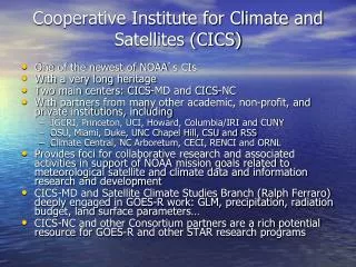
Cooperative Institute for Climate Studies (CICS). The purpose of CICS is to: Foster collaborative research between NOAA and the University of Maryland in studies of satellite climatology, climate diagnostics, modeling and prediction.

E N D
Cooperative Institute for Climate Studies (CICS) The purpose of CICS is to: Foster collaborative research between NOAA and the University of Maryland in studies of satellite climatology, climate diagnostics, modeling and prediction. Serve as a center at which scientists and engineers working on problems of mutual interest may focus on studies contributing to the understanding of the earth-ocean-atmosphere climate system, climate modeling, climate prediction, and satellite climatology. Stimulate the training of scientists and engineers in appropriate disciplines
For two decades CICS has fostered collaborative research between NOAA and the University that has covered a wide range of problems in radiation budget studies, climate diagnostics and atmospheric chemistry. Three major research theme areas have evolved within CICS, namely: • Global Energy and Water Cycles, • Climate Diagnostics and Prediction, and • Atmospheric Chemistry
Outline • Mapping against NOAA Mission Goals • Personnel Changes • Highlights • New Building • Issues
Meeting NOAA Mission Goals • Involvement in and with NOAA Weather & Water, Climate, and Ecosystem Goal Teams • Outreach & Education • Lecturing ESSIC & METO courses • Presenting seminars • Interacting with undergraduates • Development of Innovative Product Systems for Environmental Monitoring and Prediction • Integrated ecosystem of the Chesapeake Bay watershed and estuary
NOAA Related Activities • Research to Operations • OLR, Precipitation • Product validation and analysis leading to user confidence and potential Climate Data Records • Products: Precipitation, Water Vapor, E/P • Satellite Services • NOAA Satellites: POES, GOES, NPOESS • Non-NOAA: EOS, TRMM, ADEOS-II • Innovative Product System Development • Initiate construction of a fully, integrated ecosystem model of the Chesapeake Bay for near-real time applications and climate research • Supports NOAA 5 & 20-Year Vision
Personnel Updates • Departing • Jeff McCollum • Dave Salapata • Arief Sudradjat • Arnold Gruber • Arriving • CICS Coordinator • Nai-Yu Wang • Jiangtao Xu • Arnold Gruber • Matt Sapiano • Extended Sick Leave • Bruce Ramsay
Highlights • Continued Advancement of OLR and Precipitation Retrievals • Renewed Emphasis on the “Cs” in CICS both Cooperative and Climate • Initiation of Marine Ecosystem Efforts
Development of a CERES Outgoing Longwave Radiation Data Set Compatible With Current Operational OLR Data: A Pre-NPOESS Risk Reduction Study for the CERES Instrument Hai-Tien Lee (CICS/ESSIC-NOAA) Istvan Laszlo (NOAA/NESDIS) Arnold Gruber (CICS/ESSIC-NOAA) Robert G. Ellingson (FSU)
Comparison of HIRS and AVHRR OLR to Broadband Measurement • HIRS OLR (black) agrees very well with the broadband measurements from ERBE and CERES (pink) including the Nino3 / 4 regions. • AVHRR OLR (green) has large biases in Nino3 region that is related to its insensitivity to water vapor variation. For Nino4 where OLR variation is mainly cloud driven, AVHRR OLR agrees better with the broadband measurements. Nino3 Nino4
Development of Longwave Radiation Budget Productsfor GOES-R ABI and HES Instruments Hai-Tien Lee (CICS/ESSIC-NOAA) Istvan Laszlo (NOAA/NESDIS)
GOES Can Provide Accurate OLR Diurnal Variation Sample GOES OLR product with 3-hourly observations. OLR has large diurnal variations, particularly over land. Insufficient temporal sampling by, e.g., polar orbiters, can cause large regional errors/biases in OLR monthly/daily mean. Geostationary satellites with continuous and frequent observations could provide accurate estimate of OLR diurnal variation and therefore accurate monthly/daily means.
Passive Microwave Coastline Rainfall RetrievalsJeff McCollum & Ralph Ferraro • Problem has always plagued the microwave (MW) rainfall retrieval community • Emissivity contrast between land (H) & ocean (L) • Large FOV’s of MW sensors (~10 km) • Varying FOV’s of MW sensors • “Mixed” pixels at and adjacent to coast • Problem typically avoided by employing broad land/sea/coast tags • Dealt with in 1990’s; never really revisited • Results in tagging potential coastal rain areas as “indeterminate” • Expanded our GPROF (Goddard Profiling Algorithm) over land retrieval work to re-evaluate and improve coastal retrievals • GPROF is used for TRMM/TMI, AMSR-E and SSM/I
Latitude Rain Frequency McCollum and Ferraro, 2005: JAOT (in press) • Improved coastline scheme developed through TMI and PR match-ups • Able to retrieve coastline rain rates of > 2 mm/hr • Unable to improve retrieval for rain rates <2 mm/hr • Adopted for use in GPROF V2004 (TMI & AMSR-E)
Climate Analysis, Reanalysis and Synthesis • NOAA’s commitment to GEOSS requires a leading role in the analysis and synthesis of climate observations • CICS personnel are helping NOAA rise to this challenge in several areas • Atmospheric Reanalysis: • Boulder workshop, CCSP development, planning for future atmospheric reanalyses • Ocean Analysis/Reanalysis: • Organization and Chairing of Team of Experts for ocean analysis for NOAA’s Office of Climate Observations • Synthesis/Analysis of Global Precipitation: • Planning/initial development for reanalysis of satellite era global precipitation, reconstruction of longer time series, evaluation of high resolution precipitation products
Atmospheric Reanalysis • Boulder workshop: • Workshop on Ongoing Analysis of the Climate System: 18-20 August 2003, Boulder, Colorado • See workshop web site (http://www.joss.ucar.edu/joss_psg/meetings/climatesystem/) for pdf version of report and background information from the workshop • U.S. needs to establish a National Program for Ongoing Analysis of the Climate System to provide a retrospective and ongoing physically consistent synthesis of earth observations • CCSP development: • Science Working Group led by Siegfried Schubert/Glenn White • Report available on same web site • Prospectus being prepared now; September workshop planned • Planning for future atmospheric reanalyses: • Need for program planning • Need focus and leadership for NOAA, National analysis and synthesis activities
Ocean Analysis/Reanalysis • CLIVAR Global Synthesis and Observations Panel sponsored November 2004 workshop: • Identified requirements and role for ocean reanalyses and current state-of-the-art • Established process for fostering future efforts • NOAA Office of Climate Observations identified need for analysis effort to complement Ocean Observing System: • Encouraged development of NCEP web site (joint EMC/CPC effort) to provide access to operational ocean analysis products • Established Team of Experts (Chaired by Phil Arkin) to compare ocean observations and derived products with analyses and make recommendations
Synthesis/Analysis of Global Precipitation • Precipitation observation and analysis is a long-standing focus of CICS (both GPCP and CMAP were associated) • GPCP Assessment as well as GEWEX and IGOS-P Integrated Global Water Cycle Theme have clarified the need for a coordinated program of analysis and development – CICS personnel are involved both technically and programmatically in all aspects • Satellite era reanalysis of global precipitation: • GPCP and CMAP, while excellent contributions, have issues associated with data homogeneity and analysis approach • New global analysis of 1988 – present feasible and required; initial development underway at CICS • Extension of historical record: • Need for longer record to understand decadal variations and trends • CICS personnel leading an effort to reconstruct the 1950 – present period • Evaluation of high resolution precipitation products: • Numerous high resolution (25 km/3 hourly) precipitation products now available • A thorough evaluation of these products is needed to plan for production of extended record • CICS is leading a Pilot Evaluation of High Resolution Precipitation Products (PEHRPP)
GPCP Interdecadal Variations • First 4 Rotated EOFs of annual average GPCP (57% of total variance). • First 3: ENSO or ENSO-like modes (51% of variance). Some interdecadal oscillations in the 3rd mode. • 4th: interdecadal trend (6% of total variance). • Tendency for mostly increased precipitation over oceans, with decreases over much of the land. NOAA/NCDC & CICS/ESSIC
Chesapeake Bay EcosystemMonitoring & Prediction • Objective:Develop a fully integrated, ecological model of the Chesapeake Bay and its watershed that assimilates in-situ and satellite-derived data by adapting and connecting existing models • Purpose: • Near-Real Time Applications: Nowcasting and forecasting of marine organisms, ocean health, and coastal conditions • Climate Research: Estimating effect of climate change on the health of coastal marine ecosystems • Partners: CoRP/SCSB, CICS, ESSIC and other UM and UMCES* departments SeaWiFS true-color image of Mid-Atlantic Region from April 12, 1998. Image provided by the SeaWiFS Project, NASA/Goddard Space Flight Center and ORBIMAGE * University of Maryland Center of Environmental Science
Preliminary configuration of the Weather Research and Forecasting (WRF) Modeling System for the Chesapeake Bay watershed region
Hybrid Coupled Ocean-Atmosphere Model With and Without Seasonal Dependency to Penetrating Radiation
NCEP and NESDIS Future Location NOAA Center for Weather and Climate Prediction UMD Research Park, College Park (Early FY08)
Issues (from 04 Retreat) • Process by which NESDIS “needs” can be communicated to CI’s in a more regular/formal manner • Process by which activities, algorithms, products, etc. of university partners can be brought to the attention of NESDIS in a more regular/formal manner • Personnel exchanges: propose that CI’s exchange information of recent and forthcoming Ph.D.s and thesis topics • OMB Program Assessment Rating Tool (PART) treats research grants like performance based contracts. Where and how do we charge extra overhead required for this reporting? • NESDIS research not very visible in NOAA Research Review
Issues • CICS 5-Year Review and CI Policy • Status ? • CICS Reporting – Change to once / year • Consolidate funding actions across Line Offices to facilitate grant submission • Kathy LeFevre retiring end of year – training of replacement(s) to avoid future problems • Engagement with other NOAA (OAR) CIs
Issues • How can we stimulate more cross - institute collaborations? • Allow short-term visits to CI's to stimulate collaborations, e.g. present a seminar, meet with scientists to discuss proposal strategy, write proposals, etc. • Permit internships and sabbaticals for students and CI scientists to work at another CI on a joint research project • Staffing at SCSB – down to critical mass; require more to enhance and create new linkages in advance of new building • Branch Head replacement • New FTEs: land surface processes person, phys ocn, etc • Temporary assignments at SCSB / CICS (?)
Climate Analysis, Reanalysis and Synthesis • NOAA’s commitment to GEOSS requires a leading role in the analysis and synthesis of climate observations • CICS personnel are helping NOAA rise to this challenge in several areas, including: • Atmospheric Reanalysis • Ocean Analysis/Reanalysis: • Synthesis/Analysis of Global Precipitation: