Download
1 / 1
10 likes | 106 Views
Comparison of atmospheric profiles from hyperspectral and multispectral IR radiances on depicting hurricane thermodynamic structures. Hong Qiu (hong.qiu@ssec.wisc.edu) Cooperative Institute for Meteorological Satellite Studies (CIMSS), University of Wisconsin-Madison, Madison, WI

E N D
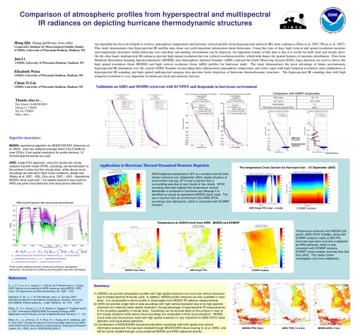
Comparison of atmospheric profiles from hyperspectral and multispectral IR radiances on depicting hurricane thermodynamic structures Hong Qiu (hong.qiu@ssec.wisc.edu) Cooperative Institute for Meteorological Satellite Studies (CIMSS), University of Wisconsin-Madison, Madison, WI Jun Li CIMSS, University of Wisconsin-Madison, Madison, WI Elisabeth Weisz CIMSS, University of Wisconsin-Madison, Madison, WI Chian-Yi Liu CIMSS, University of Wisconsin-Madison, Madison, WI An algorithm has been developed to retrieve atmospheric temperature and moisture vertical profiles from hyperspectral infrared (IR) alone radiances (Zhou et al. 2007; Weisz et al. 2007). This study demonstrates that hyperspectral IR satellite data alone can yield important information about hurricanes. Using this type of data, high vertical and spatial resolution moisture and temperature structures within hurricane eyes and their surrounding environment can be depicted. An important feature of this data is that it is useful for both clear and cloudy skies. On the other hand, multispectral IR radiances provide high spatial resolution but low vertical resolution profiles, which help depict the spatial features of moisture distribution. Data from Moderate Resolution Imaging Spectroradiometer (MODIS) and Atmospheric Infrared Sounder (AIRS) onboard the Earth Observing System (EOS) Aqua platform are used to derive the high spatial resolution (from MODIS) and high vertical resolution (from AIRS) profiles for hurricane study. The study demonstrates the great advantage of future geostationary hyperspectral IR instrument over the current GOES Sounder on providing three dimensional atmospheric temperature and water vapor with high temporal resolution, and combination of hyperspectral IR sounding and high spatial multispectral imaging data provides better depiction of hurricane thermodynamic structures. The hyperspectral IR sounding data with high temporal resolution is very important for hurricane track and intensity forecast. Validation on AIRS and MODIS retrievals with ECMWF and dropsonde in hurricane environment Thanks also to… Tim Schmit, StAR/NESDIS Jinlong Li, CIMSS Xin Jin, CIMSS Many others Algorithm description: MODIS: operational algorithm for MOD07/MYD07 (Seemann et al. 2003), clear sky radiance average within 5 by 5 fields-of-view (FOVs, 5 km spatial resolution) for profile retrieval, 12 infrared spectral bands are used AIRS: single FOV approach, using the cloudy fast cloudy radiative transfer model (RTM), soundings are derived down to the surface in clear and thin cloudy skies, while above-cloud soundings are derived in thick cloud conditions, details see (Weisz et al. 2007 - GRL; Zhou et al. 2007 – JAS). Operational MODIS cloud mask with 1 km spatial resolution was used for AIRS sub-pixel cloud detection and cloud phase detection. Applications to Hurricane Thermal Dynamical Structure Depiction AIRS brightness temperature (BT) at a window channel (left) shows hurricane Ivan (September 2004) spatial structure of environment and eye, BT of eye is warmer than it surrounding area due to less clouds or low clouds. SFOV sounding retrievals indicate that temperature vertical distribution is achieved in Hurricane eye although it is identified as cloudy by operational MODIS cloud mask. The eye is warmer than its environment from AIRS SFOV soundings (see right panel), which is consistent with ECMWF analysis. Temperature at 250hPa level from AIRS , MODIS and ECMWF Temperature retrievals from MODIS (left panel), AIRS SFOV (middle), along with ECMWF analysis (right) at 250 hPa. Hurricane eye warm anomaly is depicted by AIRS retrievals, which is also consistent with ECMWF analysis. ECMWF shows weaker anomaly than that from AIRS. This needs further investigation and more validations. A fast cloudy radiative transfer model accounting for atmospheric absorption, cloud particle scattering and absorption has been developed. MODIS Clear (5Km) AIRS Single FOV ECMWF analysis References Li, J., C.-Y. Liu, H.-L. Huang, T. J. Schmit, W. P. Menzel and J. J. Gurka, 2005: Optimal cloud-clearing for AIRS radiances using MODIS, IEEE Trans. On Geoscience and Remote Sensing. 43, 1266 – 1278. Seemann, S. W., Li, J.,W. Paul Menzel, and L. E. Gumley, 2003: Operational retrieval of atmospheric temperature, moisture, and ozone from MODIS infrared radiances, J. Appl. Meteorol. 42, 1072 - 1091. Weisz, E., H.-L. Huang, J. Li, E. E. Borbas, K. Baggett, P. Thapliyal and G. Li, 2007: International MODIS/AIRS Processing Package: AIRS Applications and Products, Journal of Applied Remote Sensing, 1, 1 – 23. Weisz, E., J. Li, Jinlong Li, D. K. Zhou, H.-L. Huang, M. D. Goldberg, and P. Yang, 2007: Cloudy sounding and cloud-top height retrieval from AIRS alone single field-of-view radiance measurements, Geophysical Research Letters, 34, L12802, doi:10.1029/2007GL030219. • Summary: • MODIS can provide atmospheric profiles with high spatial resolution but much low vertical resolution due to limited spectral IR bands used. In addition, MODIS profile retrievals are only available in clear skies. It is not possible to derive profile in cloud region from MODIS IR radiance measurements. • AIRS can provide single field of view soundings with high vertical resolution due to its high spectral resolution but relatively lower spatial resolution, the big advantage of hyperspectral IR measurements is the sounding capability in cloudy skies. Soundings can be derived down to the surface in clear or thin cloudy situations while above cloud soundings are achievable in thick cloud situations. MODIS cloud mask and cloud phase mask with high spatial resolution is very important for AIRS SFOV cloud detection and cloud phase detection. • Combination of MODIS/AIRS should provide better soundings with both spatial and vertical information preserved, this has been studied through MODIS/AIRS cloud-clearing (Li et al. 2005), and will be further studied through using combined MODIS and AIRS radiances directly. Preliminary MODIS TPW (1km) AIRS TPW (13.5 km) MODIS/AIRS (1 km)