Download
1 / 31
310 likes | 443 Views
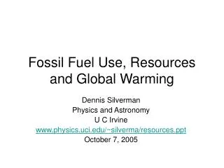
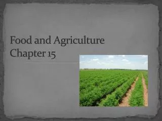
Welcome to the Presentation on. Global Warming and Sea Level Rising: Impact on Bangladesh Agriculture and Food Security. by Prof. Dr. M.A. Halim Khan, Principal Investigator & Dr. M.A. Awal, Co-Investigator Department of Crop Botany Bangladesh Agricultural University

E N D
Welcome to the Presentation on Global Warming and Sea Level Rising: Impact on Bangladesh Agriculture and Food Security by Prof. Dr. M.A. Halim Khan, Principal Investigator & Dr. M.A. Awal, Co-Investigator Department of Crop Botany Bangladesh Agricultural University Mymensingh-2202, Bangladesh
Why global warming? Fig. 1: Green house gasses and their contribution
The emissions of CO2 have been dramatically increased since 1958 and are still increasing by about 1.5 ppmv/annum Fig. 2: Time series of CO2 concentration
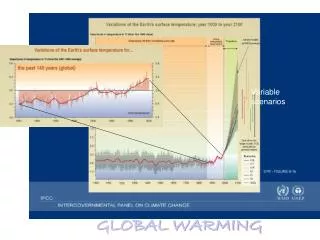
During 1880-1935, the temperature anomaly was consistently negative. In contrast, from 1980 it is constantly positive having highest anomalies of +0.4 to +0.6oC. Fig. 3: Time series of global temperature anomaly
The IPCC predicted global temperature increase in the 21st century as: Low: ~ 1oC Medium: ~ 2oC High: ~ 3.5oC. Fig. 4: Global temperature projections to the year 2100
Fig. 7: Modeled sea level rise from 1765 to 2100. The uncertainty range is for uncertainty in the climate sensitivity only.
Consequences of global warming Broader perspective Regional perspective ● Shifting in climatic patterns, arid & semi-arid regions, vegetation & forests ●Erratic rainfall, drought & floods ●Cold & hot spells ●Drought & desertification ●Tidal surges ●Inundation of low-lying areas ●Melting of glaciers & ices ●Thermal expansion of sea water & sea-level rising ●Increasing coastal salinity ●Cyclones & tornadoes
Consequences of global warming & sea level rising on Bangladesh agriculture and food security Long –term effects Disastrous effects ●Inundation of low-lying coastal areas ● Occurrence of frequent cyclones, tornadoes, floods & droughts ●Incursion by salinity in coastal cultivable lands & loss of soil fertility & ecosystem productivity ● Infrastructural damage including roads & highways, dwelling houses & embankments ● Changes in the land-use pattern that includes coastal agriculture, fisheries, live stocks & mangroves ● Erosion of river banks, estuaries, channels & canals ● Destruction of standing crops, shrimp hatcheries & fresh water aquifers in the coastal areas All these should have cumulative effects on Food security & creation of climatic refugees
Why the global warming/sea-level rising is important to Bangladesh? Presence of a specialized cone/funnel shaped Bay guides most of the cyclones to strike Bangladesh coast Fig. 8: Map of the Indian sub-continent and Bay of Bengal
Objectives ❖ To evaluate the status of low-lying coastal areas and off-shore islands, ❖ To asses the vulnerability of coastal population due to predicted sea level rising, ❖ To find out the agricultural enterprises which under the immediate threat of up-coming sea level rising, ❖ To explore the tactic regarding food security against predicted sea level rising.
Major activities ❖ Data collection - secondary & primary ❖ Case studies ❖ Field study ❖ Chemical analysis ❖ Data analysis
Collection of secondary data ❖ Relevant information on global warming and sea-level rising have been accumulated by consulting books, journals, periodicals, browsing internets, personal communications, attending seminars and symposia and visiting various institutes/organizations. ❖Climatic parameters like temperature, humidity, rainfall, cyclones, tidal surges etc. and geo-morphological information covering elevation, estuaries, embankments, floods, tides and projected areas of inundation etc. of the coastal regions of Bangladesh have been collected by visiting pertinent organizations and websites. Collection of primary data ❖ The land-use patterns, managements and socio-economic aspects of the coastal people of Barisal, Khulna and Chittagong Divisions have been collected by case studies together with the collection of water and soil samples for salinity studies.
Study sites Fig. 9. Locations of sites visited for studies are shown in the boxes
Trends of variation of seasonal mean maximum temperature Despite great fluctuations the mean temperature in pre-monsoon appeared to be static while south-west monsoon and post-monsoon temperatures are continually increasing since 1961 Fig. 10: Country average (mean from 24-34 stations throughout the country) temperature in Bangladesh from 1961 to 2007.
Trends of maximum/minimum temperatures in Bangladesh Fig. 11: Country average (mean from 24-34 stations throughout the country) temperature of Bangladesh from 1961 to 2007.
Trends of seasonal and annual total rainfall in Bangladesh Extreme yearly fluctuations are noticeable since 1961. However, the regression lines computed from 5-year moving average indicate increasing trend in the amount of total rainfall Fig. 12: Country average (mean from 24-34 stations throughout the country) rainfall in Bangladesh from 1961 to 2007.
Table 1: Projected global warming and rainfall scenarios in Bangladesh Source: Coastal Developmental Strategy, 2006. Water Resources Planning Organization, Ministry of Water Resources, GOB Table 2: Land area* inundation due to projected sea-level rise in Bangladesh * Barisal, Patuakhali and Khulna regions are most at risk from sea level rise. Source: Coastal Developmental Strategy, 2006. Water Resources Planning Organization, Ministry of Water Resources, GOB
Table 3: Features of vulnerable districts in the coastal zones of Bangladesh *Source: BBS, 2004
Topography of Bangladesh Most of the coastal parts and associated islands of Khulna, Barisal and Chittagong Divisions lie within 1m from sea level where incursion of saline water is common. And these areas will be inundated and unsuitable for crop production due to sea-level rise in next 50 years Fig. 13: Topographic map of Bangladesh
Fig. 14: Inundation pruned area of Bangladesh due to up coming sea-level rise
Table 4: Present land-use patterns in the coastal zones of Bangladesh
Table 5: Level of salinity of soil and water as observed in some selected coastal areas Note: Electrical conductivity (Ec) 0-2, 2.1-4, 4.1-8, 8.1-15 and >15 ds M-1 respectively indicate non-saline, slightly saline, moderately saline, saline and strongly saline conditions for crop production (source: USDA, Agriculture Hand Book # 60, cited from Khan et al., 2008).
Fig. 15: In spite of nearness to water sources vast cultivable land remain fallow during the Boro season in places of Barisal Division (photographs taken on 16 April 2008).
Fig. Vast lands are remained fallow in spite of water in Bagherhat (photographs taken on 21 May 2008). Fig. 16: In spite of nearness to water sources vast cultivable land remain fallow during the Boro season in places of Bagerhat of Khulna Division (photographs taken on 21 May 2008).
Fig. 17: Boro rice (hybrid var. Alo) has been successfully cultivated in Bhashanzal, Morolganj of Bagherhat by using the locally available surface water (photographs taken on 21 May 2008).
Fig. 18: Shrimp cultivation is more popular than paddy in Mongla, Khulna region (pictures taken on 22 May 2008).
Fig. 19: Coastal zone climate and land-use patterns scenarios and model for food security
Suggestions & Conclusion ● Advancing the present cropping patterns in both Boro and Aman seasons by a fortnight should go a long way in avoiding the coastal cyclones and will mean a good harvest of rice, the main cereal of the country. ● Introduction of salt-tolerant Boro rice (also maize) will further contribute to additional production of food grains and boost food security. ● Development of submerged tolerant rice varieties capable of thriving tidal surges/floods should be the alternative option for food security.