Download
1 / 17
170 likes | 321 Views
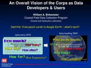
An Overall Vision of the Corps as Data Developers & Users William A. Birkemeier Coastal Field Data Collection Program Coastal and Hydraulics Laboratory. Data handling 2009. Data entry 1975. Subtitle: from punch cards to Google Earth – what’s next?. What are the benefits?. How much?. When?.

E N D
An Overall Vision of the Corps as Data Developers & UsersWilliam A. BirkemeierCoastal Field Data Collection Program Coastal and Hydraulics Laboratory Data handling 2009 Data entry 1975 Subtitle: from punch cards to Google Earth – what’s next? What are the benefits? How much? When? How many? Two years to electronically plot beach cross-sections 20 sec for an aerial view anywhere in the world, from any computer How Big? How risky? How often? How Deep? How far? How Expensive? How confident?
We answer these questions with Dataif we have it, or can find it, or can collect it, or can model it Tom Richardson addressed the CERB meeting at Duck, NC in 2002 • Data influences all phases of all projects • We need data for projects & regionally • Physical and environmental parameters • The Corps will never collect all the data we require Appropriate then, appropriate now.
The flow of data Collection Make Decisions
Wave buoy Wave Forecast The flow of data Collection Sales go down – why? It’s more complicated, more variables, model inadequate Now dependent on someone else to provide data Make Decisions
Wave buoy Wave Forecast The flow of data Collection Data Collectors don’t do this, users do!
Google & Google Earth: the Future Defined? Intuitive – allows spatial discovery of data – fast – customizable – links different data sets and People use it!
This is Big! • NDBC: • Consolidates data • Performs QA/QC • Serves it worldwide • Provides access • NDBC does not: • Use/analyze data • Develop products • Long-term Archive • Include all data • Have to go elsewhere Data Evolution Example: National Data Buoy Center Website
Prototype Decision Tool for Coastal Flooding & Erosion Predicted and past 4 hours(User clicks through forecast)
Profile Line 188 27 Jan 98 1 Feb 98 19 Feb 98 Elevation (m) Distance (m) To Predict the Future - Look BackThe evolution of the beach profile (abridged version)
The evolution of the beach profile Profile Line 188 27 Jan 98 1 Feb 98 19 Feb 98 Elevation (m) Distance (m)
Coastal Lidar And Radar Imaging System (CLARIS) Beach lidar system Integrated, mobile system for a seamless map of beach topography and nearshore bathymetry – (The future looks bright!) Topo-Lidar Time-exposure for sandbars Bathymetry from wave field inversion +
Wave buoy Re-format Wave Forecast ...and in the Future? Spatial Discovery“Deep” web “User friendly” Acquire • High resolution remote sensing • Smaller sensors, • Better batteries Collection Collection New Sensors Quality control Quality control Integrate w/other datacustomizable Standard Formats, including GIS Analyze/Explorestandard tools More Powerful Servers Integrated Productsanimated, customized EstablishedArchives InterpretScenario testing Everything improves.... Better Decisions
Data Truisms • Collect once, use many times • Real-time data for operations, becomes long-term climate & extreme-event record • Make it available; it will be used • Standardize new data, then add historic • Users don’t care who collected it, they just want it • To identify users, turn off the data – they’ll let you know! • Data are time-sensitive, You only get one chance • Data gaps are permanent • Extreme events often missing - critical • Start collecting now the data we will need tomorrow • 24/7 Field Data Collection requires: • Operational attitude: standard procedures • Staff dedication, expertise • Funding (equipment, logistic support, staffing) • Organizational commitment
Celebrating 35 years in 2010vision & commitment Robert Wiegel Ron Flick (CDBW) Dick Seymour Orville Magoon George Domurat Founding Fathers of CDIP Early Players
Actions for the Corps • Define data requirements • Establish Priorities • Assign Resources • Take advantage of Partnerships • Be Forward Thinking