Download
1 / 5
70 likes | 732 Views
Photogrammetry is the science of making measurements from photographs.The output of photogrammetry is typically a map, drawing or a 3d model of some real-world object or scene. SBLGEOMATICS assures solutions for all standard tasks in a digital photogrammetry and remote sensing services that range from aerial triangulation, DEM/DTM generation and stereo compilation to classification and change detection studies.

E N D
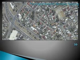
Photogrammetric Remote Sensing Orthophoto generation
Aerial Triangulation in Photogrammetry Aerial photogrammetryis a technique for creating two dimensional (2D) or three dimensional (3D) models from high points. The images used in aerial photogrammetry are usually taken by using cameras which are placed on the underside of aircrafts. In this techniques tow or more photos of same areas with different angles are used. Aerial triangulation is the technique used here. It is mostly used in topographical mapping
Orthophoto Generation Orthorectification transforms the central projection of the photograph into an orthogonal view of the ground, thereby removing the distorting effects of tilt and terrain relief. The by-product of orthorectification process is orthoimage or orthophotos.
Color Infrared Orthophoto The photographs obtained from color infrared aerial photography film is called Color Infrared orthophoto ( CIR ). It is commonly used used to study vegetation coverage, crop coverage, forest plantation studies, forest landuse etc mainly recording the chlorophyl content and in some of the GIS applications.
For Quality GIS Services visit :-http://www.sblgis.com/SBL Sri Niketan, Palace No.10 Tripunithura, Cochin mail:-gayathril@sblinfo.com Ph : 91 484 2784057