Download
1 / 19
190 likes | 377 Views
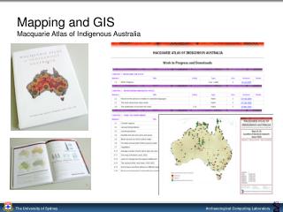
Mapping and GIS Macquarie Atlas of Indigenous Australia. MacAtlas Online. MacquarieNet – On-line Reference Library. www.macnet.mq.edu.au. Sydney Time Map 2000 - Museum of Sydney.

E N D
MacquarieNet – On-line Reference Library www.macnet.mq.edu.au
Sydney TimeMap 2000 - Museum of Sydney ‘a multi-media,multi-disciplinary installation about the nature and narrationof this place now called Sydney.’ ARC SPIRT grant 2000-2002Industry partner: Museum of Sydney
Dictionary of Sydney (2006-2009) Interim web site (Morpheum P/L) Contribution management system andresearch into metadata and web delivery (ACL) Dictionary of Sydney (ARC Linkage) 2006-2010Industry partners: City of Sydney, NSW Archives, NSW State Library
Spatio-temporal search • Modeling events • Bounding boxes / pseudo georeference • Searching for resources • Spatial relevance • Temporal relevance • Visual cues • Bounding boxes • Map density image • Time graph • Time lines
PARADISECPacific And Regional Archive for Digital Sources in Endangered Cultures
David Rumsey Map Collection www.davidrumsey.com
ECAI: The Electronic Cultural Atlas Initiative www.ecai.org TimeMap™ 1997 –
Database-generated historical map animation Khmer, Korea, Mughal, Mongol, Chinese Dynasties, Sydney etc. Morphing Blending Effectiveness of animations / interaction / participation. GREV
Historical Atlas of South AsiaSouth East Asia Area and Languages Centre, University of Chicago
Timelines project • Timelines bibliography (Heurist) • Database model • Visual representation • Generalisation • Linking • Implementation
SHSSERI Sydney Humanities and Social Sciences e-Research Initiative
SHSSERI Web site http://acl.arts.usyd.edu.au/shsseri Includes HEURIST, T1000 and other tools Register as a user at the login page