Download
1 / 48
480 likes | 681 Views
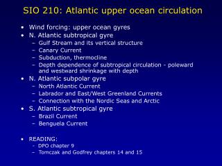
SIO 210: Atlantic upper ocean circulation. Wind forcing: upper ocean gyres N. Atlantic subtropical gyre Gulf Stream and its vertical structure Canary Current Subduction, thermocline Depth dependence of subtropical circulation - poleward and westward shrinkage with depth

E N D
SIO 210: Atlantic upper ocean circulation • Wind forcing: upper ocean gyres • N. Atlantic subtropical gyre • Gulf Stream and its vertical structure • Canary Current • Subduction, thermocline • Depth dependence of subtropical circulation - poleward and westward shrinkage with depth • N. Atlantic subpolar gyre • North Atlantic Current • Labrador and East/West Greenland Currents • Connection with the Nordic Seas and Arctic • S. Atlantic subtropical gyre • Brazil Current • Benguela Current • READING: - DPO chapter 9 • Tomczak and Godfrey chapters 14 and 15
Review: wind stress and Ekman pumping WESTERLIES TRADES TRADES WESTERLIES DPO Fig. 9.2
Sverdrup transport and actual circulation (Tomczak and Godfrey) Subpolar gyre Subtropical gyre Subtropical gyre Subpolar gyre (Antarctic Circumpolar Current)
Western Boundary Currents of the upper ocean gyres N. Atlantic subpolar gyre: Labrador Current N. Atlantic subtropical gyre: Gulf Stream S. Atlantic ST gyre WBC: Brazil Current
Mean sea surface topography (cm) from surface drifters (Niiler et al, 2004)
Gulf stream: Sea surface temperature (satellite) and Benjamin Franklin’s map SST satellite image, from U. Miami RSMAS Richardson, Science (1980)
Gulf Stream nomenclature Kawai, in Kuroshio (1972)
Gulf Stream velocity in Florida Strait (cm/sec) (> 160 cm/sec at max) GEOSTROPHY ! Roemmich, JPO ( 1983) Assuming no motion at depth is a poor assumption here…
Gulf Stream velocity section(> 160 cm/sec at max) Halkin and Rossby, JPO ( 1985)
A water mass associated with the Gulf Stream: Subtropical Mode Water (Eighteen Degree Water) Section across Gulf Stream Thickening of isopycnals is the water mass (DPO Figure 8.21) See blackboard example for estimating sea surface height and Gulf Stream transport from this….
Rough estimate from previous density section gives - 0.5m surface height change across Gulf Stream - 50Sv transport in upper 1000m
Subtropical Mode Water (“Eighteen Degree Water”) Thick layer just south of the Gulf Stream: figures from Kwon and Riser Profiles Temperature (1981) Thickness(1981)
Gulf Stream at depth: from acoustically-tracked floats (Owens et al., 1991) and geostrophic analysis (Reid, 1994) Eastward Gulf Stream at 2000 m Westward flow on both sides: northern side is along boundary and can be considered a “Deep Western Boundary Current” (introduced later). Southern side is a “recirculation”
Gulf Stream circulation at bottom: current meters (Joyce and Schmitz, JPO 1983) and geostrophic analysis (Reid, 1994) Eastward Gulf Stream found to ocean bottom Westward flows on both sides - same explanations as at 2000 m
Not easy to measure full depth and time variability of the Gulf Stream: Here example from VOS line with ADCP and XBT New York-Bermuda(Tom Rossby)
CORC project: • Moorings: • determine net mass transport, including eddies, recirculations,... • For heat transport need • vT dx dz : Gliders: provide regular upper layer T-weighting of v distribution in stream coordinates • IES+pressure: • when upper-layer flow and heat content is know, this provides lower-layer correlation of v and T. (F.Bryan et al) Merge with altimetry and up/downstream information via assimilation. For Gulf Stream, Oleander VOS ADCP sections would provide excellent upper-layer velocity reference.
Atlantic Eastern Boundary Currents:Canary Current (N. Atlantic)Benguela Current (S. Atlantic)shallow (200 m)upwelling due to long-shore winds and offshore Ekman transport
Surface: balance of wind stress and pressure gradient force Deep: Only pressure gradient, drives opposite undercurrent
N .Atlantic subtropical gyre: depth dependence of circulation and associated water masses 1. “Subduction”: creation of the thermocline by surface water that flows southward in the ST gyre and has to move under lighter surface water Water masses associated with subduction N. Atlantic Central Water (thermocline itself) Subtropical Underwater (salinity maximum water) 2. Poleward and westward shrinkage of the subtropical gyre with depth (increasing distance from the sea surface where the wind forcing is located) Very similar to N. Pacific
Surface salinity: maximum in subtropics Subsurface salinity: also maximum near this surface maximum Subduction of high salinity southward creates a subsurface salinity maximum Subtropical underwater
North Atlantic Current A second, nearly separate, subtropical western boundary current based on wind stress curl But with a connection to subpolar circulation Subpolar gyre Cyclonic circulation Western boundary currents: East Greenland Current and Labrador Current Feeding into the Norwegian Sea (Norwegian Current) Water mass in upper ocean: Subpolar Mode Water (Fratantoni, JGR 2001)
Subpolar circulation: depth dependence Note that surface gyre is not closed: part of flow goes into the Nordic Seas (due to deep overturning circulation) surface 1000 dbar Deeper gyre is closed (below sill depths into the Nordic Seas)
N. Atlantic subpolar gyre After McCartney, Progress in Oceanography (1992)
South Atlantic surface circulation (Reid, 1994) Brazil Current and Benguela Current Malvinas or Falkland Current and the Antarctic Circumpolar Current Weddell Sea gyre
Atlantic equatorial currents Surface currents (Tomczak and Godfrey ch. 14) North Brazil Current (a tropical western boundary current) North Equatorial Countercurrent in August
Simple view/explanation of basic equatorial surface currents:
Atlantic equatorial currents Equatorial currents in August (Tomczak and Godfrey ch. 14)
Atlantic surface circulation Schematic from Tomczak and Godfrey (chapter 15)Actual surface streamfunction from Reid (1994)
Gulf Stream circulation: surface circulation from drifters Davis, Ann. Rev. Fluid Mech. (1991)
Subtropical Mode Water (Eighteen Degree Water) Section from Challenger in 1873 Salinity at 300 m within a narrow range, suggesting coherent water mass Worthington (1976)
Surface flow from drifters (Flatau, Talley and Niiler, 2003)
Canary Current Eastern boundary current of the N. Atlantic subtropical gyre (figure from Tomczak and Godfrey chap. 14)
Benguela Current Eastern boundary current of the S. Atlantic subtropical gyre (figure from Tomczak and Godfrey chap. 14)
Subtropical underwater (cont.) Subduction of high salinity southward creates a subsurface salinity maximum (Worthington, 1976)
Subtropical subduction Tritium Salinity 100 m Subduction southward of surface waters creates tongues of salinity and tongues of tritium (man-made tracer, released to atmosphere mainly in the 1960s during atomic bomb testing) (Sarmiento, 1982) 200 m 500 m
South Atlantic subtropical gyre and equivalent of a subpolar gyre Brazil Current and Benguela Current Malvinas or Falkland Current and the Antarctic Circumpolar Current Weddell Sea gyre (not indicated in Tomczak/Godfrey map)
Brazil Current (from Tomczak and Godfrey; Legeckis and Gordon, 1982)