Download
1 / 29
660 likes | 2.51k Views
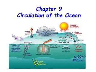
Chapter 9 Circulation of the Ocean. Surface Currents Are Driven by the Winds. The westerlies and the trade winds are two of the winds that drive the ocean’s surface currents.

E N D
Chapter 9 Circulation of the Ocean
Surface Currents Are Driven by the Winds The westerlies and the trade winds are two of the winds that drive the ocean’s surface currents. About 10% of the water in the world ocean is involved in surface currents, water flowing horizontally in the uppermost 400 meters (1,300 feet) of the ocean’s surface, driven mainly by wind friction. (left) Winds, driven by uneven solar heating and Earth’s spin, drive the movement of the ocean’s surface currents. The prime movers are the powerful westerlies and the persistent trade winds (easterlies).
Surface Currents • What are some effects of ocean currents? • Transfer heat from tropical to polar regions • Influence weather and climate • Distribute nutrients and scatter organisms • Surface currents are driven by wind: • Most of Earth’s surface wind energy is concentrated in the easterlies and westerlies. • Due to the forces of gravity, the Coriolis effect, and winds, water often moves in a circular pattern called a gyre.
Surface Currents Are Driven by the Winds The gyres circulate clockwise in the Northern Hemisphere and counterclockwise in the Southern Hemisphere. The North Atlantic gyre, a series of four interconnecting currents with different flow characteristics and temperatures.
Surface Currents Flow around the Periphery of Ocean Basins Surface water blown by the winds at point A will veer to the right of its initial path and continue to the east. Water at point B veers right and continues to the west.
The Ekman spiral and the mechanism by which it operates. Surface Currents Flow around the Periphery of Ocean Basins
90° to the right of wind direction is up here At 15°N 30°– 45° Water continues clockwise? Trade wind Direction of water movement Stepped Art Fig. 9-6, p. 237
Surface Currents Flow around the Periphery of Ocean Basins Consider the North Atlantic. The surface is raised through wind motion and Ekman transport to form a low hill. The westward-moving water at B ‘feels’ a balanced pull from two forces: the one due to Coriolis effect (which would turn the water to the right) and the one due to the pressure gradient, driven by gravity (which would turn it to the left). The hill is formed by Ekman transport. Water turns clockwise (inward) to form the dome, then descends, depressing the thermocline.
Seawater Flows in Six Great Surface Circuits Geostrophic gyres are gyres in balance between the pressure gradient and the Coriolis effect. Of the six great currents in the world’s ocean, five are geostrophic gyres. Note the western boundary currents in this map.
Boundary Currents Have Different Characteristics • Western boundary currents–These are narrow, deep, warm, fast currents found at the western boundaries of ocean basins. • The Gulf Stream • The Japan Current • The Brazil Current • The Agulhas Current • The Eastern Australian Current • Eastern boundary currents–These currents are cold, shallow and broad, and their boundaries are not well defined. • The Canary Current • The Benguela Current • The California Current • The West Australian Current • The Peru Current
Boundary Currents Have Different Characteristics The general surface circulation of the North Atlantic. Unit for measuring flow rates (or volume transported by ocean currents): sverdrups 1 sv = 1 million cubic meters of water per second
Boundary Currents Have Different Characteristics Eddy formation The western boundary of the Gulf Stream is usually distinct, marked by abrupt changes in water temperature, speed, and direction. (a) Meanders (eddies) form at this boundary as the Gulf Stream leaves the U.S. coast at Cape Hatteras. The meanders can pinch off (b) and eventually become isolated cells of warm water between the Gulf Stream and the coast (c). Likewise, cold cells can pinch off and become entrained in the Gulf Stream itself (d). (C = cold water, W = warm water; blue = cold, red = warm.)
Surface Currents Affect Weather and Climate General summer air circulation patterns of the east and west coasts of the United States. Warm ocean currents are shown in red; cold currents, in blue. Air is chilled as it approaches the west coast and warmed as it approaches the east coast.
Surface Currents Affect Weather and Climate Wind induced vertical circulation is vertical movement induced by wind-driven horizontal movement of water. Upwelling is the upward motion of water. This motion brings cold, nutrient rich water towards the surface. Downwelling is downward motion of water. It supplies the deeper ocean with dissolved gases.
Thermohaline Circulation Affects All the Ocean’s Water The movement of water due to different densities is thermohaline circulation. Remember that the ocean is density stratified, with the densest water at the bottom. There are five common water masses: Surface water = 0-200m Central water = 200-thermocline Intermediate water = thermocline-1500m Deep water = 1500-4000m Bottom water = 4000-bottom
Density Structure • Temperature increase = density decrease • Salinity increase = density increase • Density Changes • Evaporation • Sea ice formation • Melting • River influx • Precipitation Caballing = the mixing and sinking of water masses
Thermohaline Circulation • Vertical, density driven circulation, resulting from change in temperature and salinity • Continuity of flow • Water is a relatively fixed quantity in the oceans • Water can not accumulate in one location or be removed from another location without movement of water between those locations • Vertical movement of water • Horizontal movement of water
Thermohaline Circulation (THC), Surface Circulation, and Meridional Overturning Circulation (MOC, global heat connection)
Water Masses May Converge, Fall, Travel across the Seabed, and Slowly Rise A model of thermocline circulation caused by heating in lower latitudes and cooling in higher latitudes. The thermocline at middle and low latitudes is “held up” by the slow upward movement of cold water. The water layers and deep circulation of the Atlantic Ocean. Arrows indicate the direction of water movement. Convergence zones are areas where water masses approach one another.
Ocean water circulates in currents caused mainly by wind friction at the surface and by differences in water mass density beneath the surface zone. Water near the ocean surface moves to the right of the wind direction in the Northern Hemisphere, and to the left in the Southern Hemisphere. The Coriolis effect modifies the courses of currents, with currents turning clockwise in the Northern Hemisphere and counterclockwise in the Southern Hemisphere. The Coriolis effect is largely responsible for the phenomenon of westward intensification in both hemispheres. Upwelling and downwelling describe the vertical movements of water masses. Upwelling is often due to the divergence of surface currents; downwelling is often caused by surface current convergence or an increase in the density of surface water. Chapter 9 - Summary
El Niño, an anomaly in surface circulation, occurs when the trade winds falter, allowing warm water to build eastward across the Pacific at the equator. Circulation of the 90% of ocean water beneath the surface zone is driven by gravity, as dense water sinks and less dense water rises. Since density is largely a function of temperature and salinity, the movement of deep water due to density differences is called thermohaline circulation. Water masses almost always form at the ocean surface. The densest (and deepest) masses were formed by surface conditions that caused water to become very cold and salty. Because they transfer huge quantities of heat, ocean currents greatly affect world weather and climate. Chapter 9 - Summary