Download
1 / 15
150 likes | 164 Views
This article discusses the challenges of archiving geospatial data and the importance of preserving older data for cultural heritage and solving business problems. It also highlights various initiatives and approaches to geospatial data preservation.

E N D
Archiving Geospatial Data: Background to the Problem Area State Government Users Committee October 16, 2008 Steve Morris, NCSU Libraries
How Would You Describe Your Current Geospatial Archive? Bob’s hard drive Last week’s set of nightly tape backups Several boxes of CD’s and DVD’s The data back-end for our internet mapping application A collection of files in our “GIS Folder” A stand-alone spatial database An enterprise GIS
Digital Preservation Points of Failure Solutions: Migration Emulation Encapsulation XML Data is not saved, or … can’t be found, or … media is obsolete, or … media is corrupt, or … format is obsolete, or … file is corrupt, or … meaning is lost
Problem: Temporal Data Unavailability Some older inventories only available through Internet Archive • Industry focus on “latest and greatest” data • “Kill and fill” as a common approach to data management (past versions of vector data lost) Not just data loss, also: Loss of memory about data • Of superceded county orthophoto flights in NC: • Only 22% recorded in the state’s GIS inventory • Only 30% available on county map servers
Findings from Survey of Archiving Practice in NC Local Agencies “All of our data is kept monthly for 1 year; i.e., September 2006 tape will be overwritten September 2007.” “… I do a weekly backup of existing data but it is overwriting the previously saved data.” “All of our data is archived daily, then weekly, then monthly, and yearly.” “No emphasis on historical data here. We just try to keep from losing data completely. Very minimal hardware to work with and no money.”
Value in Older Data: Cultural Heritage Future uses of data are difficult to anticipate (as with Sanborn Maps)
Value in Older Data: Solving Business Problems Land use change analysis Site location analysis Real estate trends analysis Disaster response Resolution of legal challenges Impervious surface maps Suburban Development 1993/2002 Near Mecklenburg County-Cabarrus County NC border
Different Ways to Approach Preservation Current use and data sharing requirements – not archiving needs – are most likely to drive improved preservability of content and improvement of metadata Technical solutions: How do we preserve acquired content over the long term? Cultural/Organizational solutions: How do we make the data more preservable—and more prone to be preserved—from point of production?
Spatial Data Infrastructure:Where Does Archiving Fit? • Metadata standards and outreach • metadata quality, best practices • Inventories • Reduce “contact fatigue”, shareable info store • Content exchange networks • Leverage more compelling business reasons to put data in motion • Automate process, add technical & administrative metadata • Framework data communities • Snapshot frequency, schemas, format strategies
Technical Challenges with Geospatial Data • Complex vector formats: multi-file, multi-format • No non-commercial, well-supported format • Shift to web services-based access • Data ephemeral, how to record decisions? • Often: Inadequate or nonexistent metadata • Impedes discovery and use • Increasing use of spatial databases for data management • The whole is greater than the sum of the parts but the whole is very hard to preserve • Content packaging • No geospatial industry standard
Preservation Approaches: Original Data vs. “Desiccated” Data Complex data representations can be made more preservable (and less useful) through simplification
Changes in the Domain: New Location-based Content • Future value as cultural heritage resource: • More descriptive of place and function than spatial data
Changes in the Domain: Geospatial PDF PDF and GeoPDF Counterpart to analog map = datasets plus data models, symbolization, classification, annotation, etc. More data intelligence survives in PDF documents than survives in most other “desiccated” formats
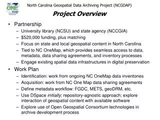
North Carolina Data Archiving Initiatives • NC Geospatial Data Archiving Project (NCGDAP) • Part of Library of Congress’ National Digital Infrastructure and Preservation Program (NDIIPP) • NCSU Libraries, CGIA: 2004 - 2009 • GICC Archival and Long-Term Access Committee • Charged Feb. 2008; report to GICC Nov. 2008 • Geospatial Multistate Archival and Preservation Partnership (GeoMAPP) • Part of NDIIPP Multistate initiative • NC (lead: CGIA and State Archives), KY, and UT • Nov. 2007 - Dec. 2009
Thank You! Steve Morris Head, Digital Library Initiatives NCSU Libraries Steven_Morris@ncsu.edu (919) 515-1361 http://www.lib.ncsu.edu/ncgdap/