Download
1 / 4
40 likes | 61 Views
The NCGDAP project aims to archive and preserve state and local geospatial content in North Carolina. It focuses on leveraging NC OneMap for data access and engages in digital preservation. The work plan includes content identification, acquisition, and metadata workflow definition. Project progress involves content acquisition, partnership building, and technical architecture development. Emerging issues include preserving cartographic representation, technical challenges, and spatial databases. The project also addresses GeoDRM initiatives and partnerships with entities like EDINA in the UK.

E N D
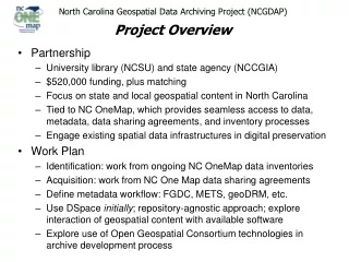
North Carolina Geospatial Data Archiving Project (NCGDAP)Project Overview • Partnership • University library (NCSU) and state agency (NCCGIA) • $520,000 funding, plus matching • Focus on state and local geospatial content in North Carolina • Tied to NC OneMap, which provides seamless access to data, metadata, data sharing agreements, and inventory processes • Engage existing spatial data infrastructures in digital preservation • Work Plan • Identification: work from ongoing NC OneMap data inventories • Acquisition: work from NC One Map data sharing agreements • Define metadata workflow: FGDC, METS, geoDRM, etc. • Use DSpace initially; repository-agnostic approach; explore interaction of geospatial content with available software • Explore use of Open Geospatial Consortium technologies in archive development process
North Carolina Geospatial Data Archiving Project (NCGDAP)Project Progress • Content Identification, Selection, and Acquisition • Completing survey analysis • Acquiring selected content (in earnest from Oct. 2005) • Pilot project focused on georegistering digital maps • Partnership Building • Completing sub-agreement with state government partners • Site visits with local and regional agencies planned • Other: NSGIC, NARA, EDINA (UK), ESRI, NPS, … • Technical Architecture Development • Completing metadata development workflow • Defining ingest workflow • Two 16 TB storage systems acquired and deployed; backup plan in place • Conducting test ingests and exports in DSpace • … Initial project focus on developing the “plumbing”
North Carolina Geospatial Data Archiving Project (NCGDAP)Emerging Issues • Preserving cartographic representation • The counterpart to the old map is the GIS data in addition to added intellectual work in the form of layer selection, symbology, annotation, etc. … Finished maps and projects form basis for policy decisions, etc. • Technical challenges associated with preserving this content, e.g. representation definitions stored in proprietary formats which do not even upwardly migrate within own software environment • Semantic issues: symbologies have particular meanings within particular contents at particular points in time • Preserving spatial databases • Increasingly, the “middle stage” geospatial information resource is stored in complex spatial databases • Some spatial database components not exportable into open file formats; quickly evolving technology and export options • ESRI Geodatabase format increasingly adopted by NC county and city agencies, especially for tax parcels and streets • Some agencies using Geodatabase as archival environment
North Carolina Geospatial Data Archiving Project (NCGDAP)Emerging Issues (continued) • Inserting preservation use cases into the GeoDRM initiative • GeoDRM driving content packaging discussion in the geospatial community; potential for focus on MPEG 21 as a solution • Partnering with EDINA in the UK • Content packaging approach: use METS initially, then follow geospatial industry direction • Engaging regional entities in the archive development process • Council of Governments active in cultivating regional spatial data infrastructure; testbeds for innovation and collaboration • COGs develop local practice for routinized data capture from county and city agencies • COGs develop scalable, intimate interagency relationships (typically 6 counties per COG vs. 100 counties in state) • NOTE: Legal cultures, translating into expectations regarding agreement language, vary at national, state, regional, local levels … consider experience of the FGDC Cooperative Agreements