Download
1 / 25
250 likes | 375 Views
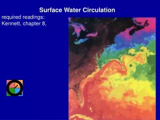
Surface Water Circulation required readings: Kennett, chapter 8,. DEFINITIONS water mass : parcel of water recognized by its physiochemical properties (generally T-S) conservative properties : only change by physical processes: mixing, diffusion, ice formation/melting

E N D
Surface Water Circulation required readings: Kennett, chapter 8,
DEFINITIONS water mass: parcel of water recognized by its physiochemical properties (generally T-S) conservativeproperties: only change by physical processes: mixing, diffusion, ice formation/melting nonconservative: change by biological or chemical processes: oxygen, nutrients (PO4, NO3, ~SiO2, certain trace elements (e.g., Cd) Temperature (conservative): Fig. 1a (Feb.); note warm pool, No. Atlantic current
Temperature in August Fig. 1b p. 126-127 Gross see also p. 238 Kennett tropics 28°C non-upwelling regions tropical upwelling: 24-26°C subtropics >18°C F bottom 1-3°C isotherms: lines of constant temperature
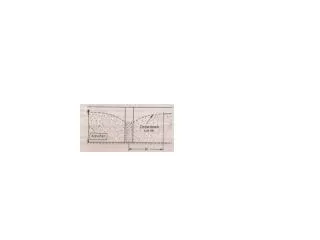
mixed layer: region mixed vertically by wind; <200 m approximates photic zone: regions where photosynthesis "pays"; <60-200m; 1% extinction point warm-water sphere (<200 m, <2% ocean volume) separated from cold water sphere (>1000m; > 80% ocean volume; temperature <4°C) permanent thermocline; rapid increase in temperature w/ depth p. 235 seasonal thermocline
Pycnocline rapid increase in density w/ depth; often follows thermocline; densityf(T, salinity, pressure); isopycnals: lines of equal density
oxygen minimum: input of O2 is from atmosphere: surface deep-water (high latitude) through advection consumption in between; minimum in water column @ intermediate depths 150-1000 m 0-3 ml/l vs. 6-7 ml/l @ saturation
salinity f(E-P) budget Mean surface ocean salinity 34.7 ‰ (“35 ppt) Range ~33-37, Med. 39 ‰, Red Sea 40+‰ Atlantic 35.37 ‰ vs. Pacific 34.7-34.8 ‰ why?
maximum in subtropical net evaporative belt tropics precip. maximum in doldrums (10°N; ITC between NE/SE Trades) halocline: rapid increase in salinity w/ depth (N. Pacific) surface salinities: open ocean 33-37 ‰ (41 ‰ in Red Sea); mean 35 deep ocean: more uniform 34.5-35 ‰
FORCES DRIVING CURRENTS wind: direct influence down to 200 m geostrophic: (usually a f(wind driven property distributions, density) thermohaline: convection driven (density driven also) consider global wind patters Hadley cell convection doldrums/ITC; NE/SE Trades horse latitudes/subtropical high; westerlies Wind driven circulation movement of water deflected to the right in the northern hemisphere by Coriolis effect (f) f = 2sin( is latitude, is angular velocity 7.3 x 10⁻⁵ 0 @ equator; acts as a force that cause defections to right and curved paths on planetary scale
Ekman Transport and the Ekman Spiral wind blows on water, iceberg drift 20-40° deflection to right theoretically 45° for surface water, translated downward to layers Fig. Kennett p. 245 net flow 90° to wind
upwelling: divergence often caused by Ekman transport.
Geostrophic currents: balance of gravity and f on density (P) driven currents cyclonic (+) around low P (ocean and atmosphere; counterclockwise flow) anticyclonic (-) around highs (e.g., Bermuda high; clockwise flow) wind blowing tends to pile up water in convergent zones; "hills" (10 cm scale) wind stress drawing; consider wind stress highs: particle motion downhill balanced by f Geostrophic flow
More Geostrophy neglects frictional forces, water circulates parallel to "hill" explains why currents circulate in gyres possible to measure slight ocean topography w/ satellites, but not precise enough to define currents use indirect measurements: T, S; take a column of water and assume k weight warmer water, less dense; therefore a warmer column occupies more space, sits up higher reference to level of no motion: compute dynamic topography amounts of transport Sverdrups: 106 m3s-1 Gulf Stream 75-120 Sv
Anticyclonic subtropical gyres: western boundary currents: Gulf Stream, Kuroshio, Brazil, E. Australian, Aguhlas narrow (<100 km), deep (surface-bottom), swift (100;'s km/day; large volume >50 Sv) eastern boundary currents (Canary, Benguela, Peru, w. Australian) eddies: cut off ocean meanders; "rings" warm core (anticyclonic), cold core (cyclonic)
draw map of streamlines of Gulf Stream, N. Atlantic, Canary, N equatorial note thermocline trends why westward intensification? linear theories (Munk, 1950) considered role of friction F must balance vorticity (spin) (+ sin(d = k where d = diameter of parcel, spin of parcel or relative vorticity winds inject clockwise vorticity (negative); To balance, parcel can either spin ccw, move toward equator (where sin( (planetary vorticity) is lower, or thicken (increase d) however, there must be a return flow in west, wall friction can inject ccw vorticity (+) balance wind negative with friction positive currents more intense in west
Equatorial circulation Pond and Emery South Equatorial Current, North Equatorial Current, Equatorial Counter Current, Meteorological Equator (5-10°N) ITCZ, divergence (upwelling) tween ECC and NEC Equtorial upwelling Equatorial (Cromwell) Current
El Nino Mark Cane illustrates striking changes in atmospheric and oceanic condition such as increased convection in the central Pacific, warming of the eastern equatorial Pacific, and a reduced east-west tilt of the thermocline that occur during an El Niño event.
monsoonal circulation seasonally reversing winds, resulting in seasonally reversing surface circ. in Indian Ocean
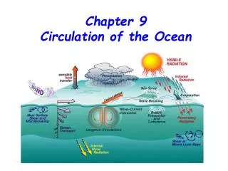
Antarctic circulation "The Southern Ocean" region of high surface productivity, deep water formation intermediate water formation driven by wind and thermohaline processes Antarctic Circumpolar Current (ACC = West Wind Drift) W to E flow driven by westerlies (Roaring 40's) surface-bottom wind driven in surface geostrophic balance below >200 Sv transport @ Drake Passage, most confined point (1000x Amazon) east wind drift (easterly wind driving coastal flow to west near continents) Subtropical Convergence 40°steep T gradient 14-18C in summer Antarctic Polar Front (APF) = Ant. Convergence 55-60°: steep T gradient 4-8°C summer