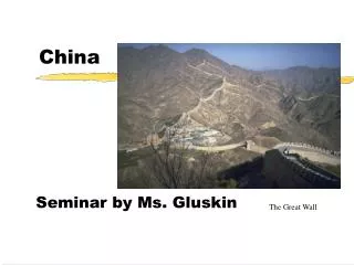
CHINA
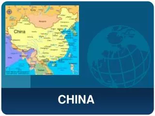
CHINA. CHINA. In eastern Asia World’s most populated country Fourth largest country in terms of area Beijing is the capital Shanghai is the largest city 70% of it is mountains, hills, and highlands Wide range of climates Most farmland and people are in the east

CHINA
E N D
Presentation Transcript
In eastern Asia World’s most populated country Fourth largest country in terms of area Beijing is the capital Shanghai is the largest city 70% of it is mountains, hills, and highlands Wide range of climates Most farmland and people are in the east Most live in towns or villages Republic government controlled by the Communist party Government controls economy but is letting more free enterprise
1 in 5 people are Chinese Most work in agriculture 90% live in eastern China 92% are Han Family is very important Live modestly Men marry after 22 Women marry after 20 Only allowed to have two kids One of the world’s oldest civilizations Developed the compass, paper, and porcelain
Countries Around the World: China thousand The Chinese language has over a ___________________ characters in it. An ancient form of writing from China is called _________________. The ________________ and _________________ are two symbols of Communism. Besides rice the ______________________ plant has been grown in China for a long time. ____________ on the Chinese flag stands for revolution, the big star represents the _______________________, and the four smaller stars stand for the __________________________ . China has a ___________________________ climate. The Chinese were the first to use _______________________ and their currency is called the _______________________ . China’s official national religion is ______________________. The __________________________________ has the most fertile soil in China. calligraphy sickle hammer soybean Red Communist Party people diverse paper money Yuan atheist Yangtze River Delta
less than 20 years ½ 1/3 traditions and rituals less than 10% Privatization – the government not owning everything It allows individuals to own land and start businesses
8 times larger their writing 34 a minute and 7 million a year construction projects Chinese New Year
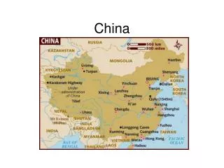
CHINA’S GEOGRAPHY and NATURAL WALL • What continent is China a part of? • This mountain range can be found along the southern border of China and India. It contains the highest mountain peak in the world. • This desert is north of the Himalayas. It is surrounded on three sides by mountains and on the east by the Tarim River. • This river originates in the eastern Himalayas and flows toward the East China Sea. It crosses the Sichuan Basin. • What direction is Egypt from China and how many miles apart are they? • This river winds across northern China from the Himalayas. It has two names - one being Chinese and the other English. • This mountain range runs along the border of China and Mongolia. It is bordered on the east and south by a desert. • This is the water body that lies between the mainland of China and the small island country of Taiwan. The Tropic of Cancer runs through this water body. 9. This eastern region in China is close to the water and is considered one of the most fertile regions in the country. It is directly south of the nation’s modern day capital city. Asia Himalayas Taklimakan Yangtze West <2300 miles Huang He ~ Yellow Altai Taiwan Strait North China Plain
What direction is India from China and how many miles apart are they? • This water body is directly to the east of China. It lies between the mainland and the island chain of Ryukyu. • This water body lies between China’s mainland and the Korean peninsula. It shares it’s name with a river that winds through eastern China. • This fertile, flat area is located in northeast China and surrounded by the Greater Khingan Range on the west and Russia on the north and east sides. 14. This desert is found on the border between China and Mongolia. • About how many miles wide and long is China? • These are China’s western mountains and can be found between China and Kyrgyzstan. 17. This large plateau is found in southwestern China. South Border one another East China Sea Yellow Sea Manchurian Plain Gobi Over 2500 miles east to west over 1000 miles north to south Tien Shan Plateau of Tibet
It is said that nature has built a natural wall around China. List the names of the physiographic features which form China’s natural wall. MOUNTAINS (4)DESERTS (2)SEAS (3) What do you think will be the advantages and disadvantages to China having a “natural wall”? ADVANTAGESDISADVANTAGES Himalaya Hindu Kush Tien Shan Altai Gobi Taklimakan Yellow East China South China Difficult to trade/travel to/with others Cause isolation Safe from invaders/protection Will have many natural resources
Yangtze River Summer Temp. = 65° F Winter Temp. = 22° F Annual Precipitation = 40 ins. Vegetation Type = rainforest The Yangtze river (meaning “Long River”) is the longest river in Asia, and the fourth longest in the world. It runs for a good 3,859 miles. To some people, it is considered a dividing line between northern and southern China.
Yangtze River Location: flows through south central China from the mountains to the sea Facts: Also known as the Chang Jiang Yangtze = Long River Longest river in China and Asia and 4th in the world It sometimes does flood People use the river to move goods between eastern and western areas in the region Its surrounding lands are very fertile
Gobi Desert Summer Temp. = 113° F Winter Temp. = -40° F Annual Precipitation = 5.5 ins. Vegetation Type = desert The word “Gobi” means very large and dry in Mongolian. The Gobi Desert is the 5th largest desert in the world and is Asia’s largest. It covers an area of about 500,000 square miles. The Gobi Desert is a cold desert, and it is not uncommon to see frost or occasionally snow on its dunes.
Gobi Desert • Location It covers part of China and Mongolia Facts • one of the world’s largest deserts • Most of the desert is stony and its surface is made up of small pebbles and tiny bits of sand • It is a cold desert, and it is not uncommon to see frost and occasionally snow on its dunes • Vegetation is sparse and the plants there tend to be small and widely spaced
Summer Temp. = -13° F Winter Temp. = -100° F Annual Precipitation = 80 inches Vegetation Type = none Himalayan Mountains . The Himalayan Mountains are the world’s highest mountain range and contain the world’s highest mountain, Mount Everest, which is over 25,000 feet high. The Himalayas extend for 1,500 miles. These mountains are extremely dangerous to travel through, not only because of their height, but also because they are always covered in snow and ice.
Himalayan Mountains • Location Along China’s southern border and forms a natural border between the Indian subcontinent Facts • the highest mountain range in the world • region is a bitterly cold place • It is so cold that there is very little or no vegetation.
Huang He (Yellow) River Summer Temp. = varies Winter Temp. = varies Annual Precipitation = 16 ins. Vegetation Type = sparse grasses The Huang He River is the second longest river in China, as well as the sixth longest river in the world. It stretches about 3,395 miles. This river is commonly known as the Yellow River, because that is the color of the river from all of the sediment it carries. Another nickname for this river is “China’s Sorrow”. It is called this because it has been known to have devastating floods.
Huang He (Yellow) River • Location It bends through north central China from the mountains to the sea Facts • Second longest river in China, 6th in the world • called the Yellow River because of the enormous amounts of yellow silt • Very muddy river • Called "the cradle of Chinese civilization", as its basin is the birthplace of ancient Chinese civilizations • the river has flooded more than 1,500 times, causing much damage and loss of life. This has also earned the river the name "China's Sorrow".
North China Plain Summer Temp. = 82° F Winter Temp. = 28° F Annual Precipitation = 23 ins. Vegetation Type = grassland The North China Plain is the largest flat lowland area in China. It stretches across an area of 158,000 square miles. The early Chinese considered this plain “the center of the world”.
North China Plain • Location • east central China Facts • is a flat region of grassland and temperatures range from very warm in the summer to cold in the winter. • called the “Land of the Yellow Earth” because the ground is covered by yellow limestone silt from the Gobi Desert • This flat yellow-soil plain is the main area of grains, corn, and cotton production in China. Wheat, sesame seed, and peanuts are also grown here. • The plain is one of the most densely populated regions in the world.
Summer Temp. = 45° F Winter Temp. = 18° F Annual Precipitation = 10 inches Vegetation Type = sparse grasses Plateau of Tibet The Tibetan Plateau is also called “the roof of the world”. It is the highest and largest plateau in the world covering an area about four times the size of Texas.
Plateau of Tibet • Location The southwestern part of China is dominated by the high Tibet Plateau Facts • This area is often called the “Roof of the World” since it is over two miles above sea level • It is a very large area, covering almost a quarter of the land in China • very cold and dry climate with sparse shrubs and grasses • The natural vegetation is eaten by antelopes and yaks that roam the area
Taklimakan Desert Summer Temp. = 100° F Winter Temp. = 15° F Annual Precipitation = 5 inches Vegetation Type = desert The Taklimakan Desert is known as the largest sand-only desert in the world. Many different mummies have been found in this desert, and some date back over four thousand years. The word “taklimakan” is known to mean “desert of death” or “place of no return”.
Taklimakan Desert • Location • located in western China, just northwest of the Tibetan Plateau Facts • Over 105,000 square miles • considered one of the most dangerous deserts in the world • “once you go in, you will not come out” • The desert’s huge sand dunes shift and change as the wind blows the sand around and sandstorms arise with stunning speed • the desert is very dry with vegetation near oases only • Legend says that two armies and three hundred cities are buried in it
Summer Temp. = 41° F Winter Temp. = 15° F Annual Precipitation = 10 ins. Vegetation Type = forest Tien Shan Mountains The Tien Shan Mountains are one of the longest mountain ranges in Central Asia. Their name means “mountains of the spirits”. The mountains at their lower levels contain many spruce forests.
Tien Shan Mountains • Location • The northwestern tip of China and lies to the north and west of the Taklimakan Desert Facts - one of the longest mountain ranges in Central Asia at 1700 miles long - The name Tien Shan literally means “celestial mountains” and is sacred to those who practice Daoism • Heavy rain and snowfall on the range create a mountain environment that contrasts dramatically with the arid desert terrain of the southern foothills • On the lower slopes, there are flowery meadows and forests • Top of them are covered with glaciers
Manchurian Plain • Summer Temp. = 75° F • Winter Temp. = 10° F • Annual Precipitation = 20 ins. • Vegetation Type = sparse grasses The Manchurian Plain is also known as the Northeast China Plain. It covers an area of over 135,000 square miles. There are almost no trees on this plain. This area is good for raising livestock and herding.
Manchurian Plain • Location • northeastern China - east of Mongolia Facts • Also known as Northeast China Plain • is a land of low hills and plains and the natural vegetation is mostly prairie grass • It has short, warm summers and is cold in the winter – dry in the north and wetter in the south • In general, the plain is too cold and dry to be a good place for growing crops but is good for herding and livestock
CHINA’S GEOGRAPHY: HELPFUL or HARMFUL Natural barriers give protection Rivers link/bring the people together Rivers flood and enrich the soil for farming Rivers used for their resources and as transportation/trade routes Natural barriers make it hard to travel and communicate Numerous regions formed and developed their own ways and, therefore, the Chinese were not unified Rivers flood, destroy, and kill Deserts are dry wastelands Southwest = mountains North and west = mountains and deserts East = ocean All of the above act as barriers keeping China both isolated and safe
China Map Key Yangtze River Gobi Desert Himalayan Mountains Huang He/Yellow (River) North China Plain Plateau of Tibet Taklimakan Desert Tien Shan (Mountains) Manchurian Plain
QUESTIONS on CHINA’S GEOGRAPHY Name the mountains found in northwest China. The Huang He River and the Yangtze River flow in which direction? What part of China are the Himalaya Mountains found in? What direction would you travel in to get from the Taklimakan Desert to the Gobi Desert? Which physiographic feature of China has the warmest summer temperature? Which physiographic feature of China has the warmest winter temperature? Tien Shan west to east eastward southern or southwestern northeast or east Gobi Desert North China Plain
Which physiographic feature of China has the overall coldest temperatures? Which physiographic features of China get over 20 inches of precipitation in a year? Which physiographic feature of China is most like Carroll County? Defend your choice with at least three reasons. Explain why over ninety percent of China’s population lives in eastern China? Himalaya Mountains Yangtze River, Himalayan Mountains, North China Plain, Manchurian Plain NORTH CHINA PLAIN: similar temperatures, both have lots of grassland, both are farming areas growing corn, somewhat similar precipitations, both on the east coast flat, reasonable temperatures, on the coast, two major rivers flow through it, fertile soil
Yangshao • Began 10,000 B.C.E • Settled near the Huang He (Yellow) River in north central China. • Were farmers in China • Had houses built partially underground with plastered floors and roofs supported by wooden beams • Created painted potterywith geometric designs on it They used a kiln but no potter’s wheel
Lungshan • About 3000 B.C.E • Settled near the Huang He (Yellow) River in northeast China. • Farmers that raised cattle, sheep, pigs, and dogs and grew wheat and millet • Eventually settled in southern China to grow rice • Leaders arose to complete projects to control flooding • Created black pottery using a kiln and a potter’s wheel • First to harvest silk from silkworms to weave fabric which became a major export of China
Xia • Last of the Prehistoric settlements around 2000 B.C.E. (ruled for about 300 years) • Settled near the Huang He (Yellow) River in north central China. • Know about them from legends and eventually what archeologists have found • Had bronze weapons and tools • Were farmers • Made pottery • Rulers communicated with spirits for help and guidance • Defeated by the Shang, China’s first dynasty Could eventually become China’s first dynasty when and if more evidence is found about them
SHANG DYNASTY • 1700-1050 BCE 2) On the Huang He River in the North China Plain 3) The Shang dynasty is important because . . . CHINA’SFIRSTDYNASTY 4) A series of rulers from the same family • From the tombs, artifacts, and writing we have found
farmers lived in the Wei Valley on the Huang He River 2) In 1050 BCE Wu the Martial and the Zhou conquered the Shang 3) China’s longest lasting dynasty 4) Tian – impersonal power (heaven) worshiped by the Zhou that demanded right behavior and good government Mandate of Heaven – getting heaven’s (tian) support if you ruled well
KING NOBLES PEASANTS owned all of the land and granted Nobles complete control of the land given them, protects and defends the land and people, govern in the interest of the people controls the land given to him from the king which consisted of a walled town and the farms around it, must give the king a portion of what the peasants produce from his land, must send the king soldiers in times of war work the farmland and give the noble some of what they produce/make, are the soldiers
6) Dialects are different forms of the same language 7) Communication from region to region was difficult because people could not always understand each other when they spoke
8) Expanded the use of writing so no matter how a word was pronounced in the different regions of China, its written form would be the same and understood. This allows China’s culture to grow and spread.