Download
1 / 27
280 likes | 417 Views
G7481 Magnetometry in geology and archaeology. L e cturer : Vojtěch Šešulka spring 2010. Geophysical methods. magnetometry gravimetry seismic geoelectric georadar geothermic. Magnetic method of geophysical survey.

E N D
G7481 Magnetometry in geology and archaeology Lecturer:VojtěchŠešulka spring 2010
Geophysical methods • magnetometry • gravimetry • seismic • geoelectric • georadar • geothermic
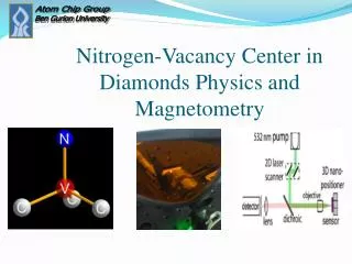
Magnetic method of geophysical survey • principal: measuring the Earth‘s magnetic field and its anomalies • observed units: - totalmagnetic field T [nT] • - magnetic field gradient DT [nT/m] • - magnetic susceptibility k [n×10e-4]
Cesium magnetometer SM-5 Navmag (Scintrex, Kanada)
Modesofmeasurements • gradiometer • (magnetic field gradientΔT [nT/m]) • variometer • (total magnetic fieldT [nT] ) Proton magnetometer PMG-1 fa in gradient mode, Geofyzika Brno
Gradiometer • two vertically placed sensors • prevents the magnetic field variations error • better for shallow objects and structures
Variometer • data collected with only one sensor • Earth‘s magnetic field variations error → neccesity of correction
Application of magnetic method • geological structuresmapping • mapping buried ferrous metal objects and other burned structures
Magnetometry in archaeology • suitable: • -countersunk objects • -fireplaces, ovens, furnaces, … • -line objects (ramparts, trenches, palisades, …) • -identification of metal objects • -detection of landfills and terrain formations • less suitable: • -communications • -stone-made object (if is used the stone from the bedrock of the site)
Measurementstypes • testing measurements • (suitability of the method) • areal measurements • (several days long measurements) • detail measurements • (the most interesting objects)
Presumption of successful project • physical contrast between the object and surroundings • good state of objects insitu • size, shape, orientation and count of objects • relief and vegetation • absence of structures, which are not in our interest • climatic conditions during the measurement • suitable combination of several geophysical methods
Magnetic method ofthegeophysicalsurvey • the measurement runs in squares (often 50×50 m) • suitable profiles orientation to the measured structure (best in N-S direction) • density of recorded data up to 0,5×0,15 m (depend on our interest)
Magnetic method fieldwork
Magnetic method interpretation
Site: NěmčicenadHanou Apparature: SM-5 Navmag (Scintrex, Canada) Author: V. Šešulka 19/09/2006
gradient T [nT/m] on the profile10 before (left) and after (right) the median correction
nT/m Site: Němčice nad Hanou Apparature: SM-5 Navmag (Scintrex, Canada) Author: V. Šešulka 19/09/2006
Magnetic method interpretation Site: Pohanskonear Břeclavi Apparature: Smartmag – 4g (Scintrex, Canada) Author: R. Křivánek 19/09/2006
Magnetic method interpretation Milo & Šešulka – Pohansko near Břeclavi 28. 3. 2007 Comparison between the measured data and the cross-section across the rampart
Milo & Šešulka Těšetice-Kyjovice 7. 3. 2007 (R – roundel; O – object; K –metal; C –path; Z – earth-house)
Magnetic method interpretation Milo & Šešulka – PohanskonearBřeclav 29. 3. 2007 (O - object; K – metal)
Magnetic method interpretation Site: Pohansko near Břeclav Apparature: Smartmag-4g (Scintrex, Canada) Author: R. Křivánek 21/08/2001 Tz gradient map (Fous etal. 2000)
Magnetic method interpretation SitePřední Arnoštov, authorV. Šešulka
Magnetic method interpretation SiteBudkovice, authorV. Šešulka
Magnetic method interpretation SitePičín, author V. Šešulka
Magnetic method interpretation SiteTěšetice-Kyjovice, author V. Šešulka
Literature used and recommended • Fous A., Hašek V. & Záhora R. (2000): Zpráva o archeogeofyzikální prospekci na akci Břeclav-Pohansko. – MS, závěrečná zpráva. Ústav archeologie a muzeologie FF MU v Brně. • Hašek V. & Měřínský Z. (1991): Geofyzikální metody v archeologii na Moravě. – MSV. Brno. • Křivánek R. (2002): Závěrečná zpráva o geofyzikálním průzkumu prováděném na základě HS č. 792/02 na lokalitě Pohansko, okr. Břeclav. – Archiv ArÚ. Praha. č.j. 7486/02. • Křivánek R. (2004): Geofyzikální metody. – In: Kuna M. (ed.):Nedestruktivní archeologie. –Academia. Praha. • Kuna etal. (2004): Nedestruktivní archeologie. – Academia. Praha.