Oregon Spatial Data Library Partnership Metadata Training
160 likes | 175 Views
This training session provides an introduction to metadata and its importance in effectively managing and sharing data sets. Learn how to create metadata using standards such as FGDC CSDGM and ISO 19115, and understand the mandatory and optional sections and fields. Discover tips for writing good metadata and selecting keywords.

Oregon Spatial Data Library Partnership Metadata Training
E N D
Presentation Transcript
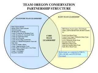
Oregon Spatial Data Library Partnership Metadata Training OU Knight Library Eugene, Oregon December 3, 2009 Kuuipo Walsh Institute for Natural Resources http://inr.oregonstate.edu/
What are metadata? • “data about data” • “information about data” • The “who”, “what”, “where”, “when”, and “how” • Information contained in the library card catalog system • Title, author, publication date, number of pages, keywords for a search system, etc. • Critical component of a complete data set • No data set should be considered complete without fully-developed, well-written metadata.
When should you create metadata? • When you want to share data sets with others • When you want to publicize data sets • When you want others to be able to decide whether or not they want to use the data set • When you want to preserve a data sets’ usefulness through time • For data sets that represent a large commitment in terms of effort and cost, this is particularly important • When you want to provide access to datasets through search engines or portals • “Data discovery, assessment, access, use, and management”
How do I create metadata? FGDC CSDGM Standard • Build a template • Adopt all mandatory fields from the standard you choose • Adopt all ‘mandatory if applicable fields’ that are pertinent • Identify ‘optional fields’ of interest • Create a pilot record from a draft template for review and revision • Don’t create you own version of a standard • Read the Introduction to Oregon Metadata Standard at http://www.oregon.gov/DAS/EISPD/GEO/standards/docs/Metadata_Opportunity.pdf • Check out the Federal Geographic Data Committee (FGDC) Web site ISO 19115 Standard Dublin Core Standard www.fgdc.gov
FGDC metadata standard: overview Seven Major Metadata Sections: • Section 1 – Identification Information* • Section 2 – Data Quality Information • Section 3 – Spatial Data Organization Information • Section 4 – Spatial Reference Information • Section 5 – Entity and Attribute Information • Section 6 – Distribution Information • Section 7 – Metadata Reference Information* Three supporting Sections • Section 8 – Citation Information* • Section 9 – Time Period Information* • Section 10 – Contact Information* * Minimum required metadata
FGDC Graphic Representation • A tool to visually describe the structure of the metadata standard • Uses color and relationships to show information: http://www.fgdc.gov/csdgmgraphical/index.html
What is Mandatory? What is Not? Yellow Mandatory: must be provided Green Mandatory if applicable: must be provided if the data set exhibits the defined characteristics Blue Optional
Oregon Metadata Standard Identification Information Citation Citation Information Originator: Publication Date: Title: Description Abstract: Purpose: Time Period of Content Time Period Information Single Date/Time (or Multiple Dates or Range of Dates) Calendar Date: Currentness Reference: Status Progress: Maintenance and Update Frequency: Spatial Domain Bounding Coordinates West Bounding Coordinate: East Bounding Coordinate: North Bounding Coordinate: South Bounding Coordinate:
What is Mandatory? What is Not? Keywords Theme Theme Keyword: Access Constraints: Use Constraints: Metadata Reference Information Metadata Date: Metadata Contact Contact Information Contact Organization Primary (or Contact Organization Primary) Contact Organization: Contact Address Address Type: Address: City: State or Province: Postal Code: Contact Voice Telephone: Metadata Standard Name: Metadata Standard Version:
How do you write good metadata? • Document for a general audience • Be consistent in style and terminology • Write simply but completely • Have someone else review your file • Define technical terms and acronyms • Don’t use jargon
Good metadata: The Title • Critical in helping readers find your data • Includes: what, where, when, who • If data are officially published, in the title include: • Series name • Issue number • Name of publisher • Location of publisher • Examples: • Ace Basin, South Carolina National Estuarine Research Reserve Digital Line Boundary • Greater Yellowstone Rivers from 1:128,700 Forest Visitor Maps (1961-1983)
Good metadata: Select keywords wisely • Use unambiguous words • Use descriptive words • Fully qualify geographic locations • Identify keyword thesaurus • The Oregon Metadata Keyword Thesaurus identifies keywords, some Oregon specific, that may be used and cited for metadata. • http://gis.oregon.gov/thesaurus
Good metadata: Review your final product • Have someone else read it • If you’re the only reviewer, put it away and read it again later • Check for clarity and omissions • Can a novice understand what you wrote? • Does the documentation present all the information needed to use or reuse the data • Are any of the pieces missing?
More Metadata Training & Info • FGDC metadata trainer directory • http://www.fgdc.gov/participation/individual/trainers/ • FGDC metadata training calendar • http://www.fgdc.gov/calendar/month • FGDC Content Standard for Digital Geospatial Metadata Workbook • http://www.fgdc.gov/metadata/documents/workbook_0501_bmk.pdf • USGS Formal metadata: information and software tools • http://geology.usgs.gov/tools/metadata/
References: • Madden, M. 2009. Manual of Geographic Information Systems. Bethesda: American Society for Photogrammetry and Remote Sensing. • NatureServe. 2005. Metadata Workshop April 14, 2005. Blaine: National Biological Information Infrastructure. • Oregon Metadata Keyword Thesaurus at:http://gis.oregon.gov/thesaurus. Accessed December 2, 2009. • Introduction to Oregon Metadata Standard at: • http://www.oregon.gov/DAS/EISPD/GEO/standards/standards.shtml • Accessed December 2, 2009.
For more information, you can contact the Oregon Explorer project team • Marc Rempel, OSU Libraries marc.rempel@oregonstate.edu • Kuuipo Walsh, OSU Institute for Natural Resources kuuipo.walsh@oregonstate.edu