Download
1 / 1
10 likes | 158 Views
Produced by EUMETSAT. Re-processed data (zero/single/double diff.): Phase, amplitude. Phase, amplitude, ground station observations, near-real time orbits. Phase, amplitude, ground station observations, precise orbits. Other RO data (COSMIC, CHAMP, ...): Phase, amplitude. Level 1a.

E N D
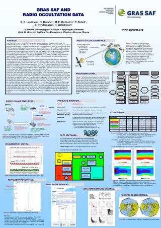
Produced by EUMETSAT Re-processed data (zero/single/double diff.): Phase, amplitude Phase, amplitude, ground station observations, near-real time orbits Phase, amplitude, ground station observations, precise orbits Other RO data (COSMIC, CHAMP, ...): Phase, amplitude Level 1a CT2 algorithm CT2 algorithm Geometric optics inversion algorithm GRAS Level 1b(CGS) NWP User EPS/PFS netCDF netCDF BUFR netCDF eps2netcdf ropp_pp Bending angle profiles (L1, L2, LC) Bending angle profiles (ionosphere corrected and statistically optimized) Bending angle profiles (ionosphere corrected and statistically optimized) Level 1b Bending angle profiles (statistically optimized) ropp2bufr(Thin or Full Level 1b/2) Abel transform algorithm Abel transform algorithm Abel transform algorithm ropp2bufr(Thin Level 2) ropp2bufr(Thin Level 1b) ropp_1dvar Climate algorithms ropp_1dvar (for Q/C) Level 2 Refractivity profiles Refractivity profiles Refractivity profiles Ancillary temperature, pressure, and humidity, from ECMWF forecasts 1D-Var algorithm 1D-Var algorithm 1D-Var algorithm ropp_fm (as part of 3/4-D Var) Bending angle, refractivity, temperature, humidity, and geopotential height grids Temperature, pressure, and humidity profiles Temperature, pressure, and humidity profiles Temperature, pressure, and humidity profiles GRASLevel 2(SAF) Level 2 NWP VAR system GRAS SAF Climate Products GRAS SAF NRT Products GRAS SAF Offline Products Level 2 EPS/Metop Measurement < 3 HRS. GRAS SAF Level 1b -> Level 2 Processing, Dissemination, Archiving, ... End Users Level 2 Data: Refractivity, pressure, temperature, and humidity profiles, Validation Data ... Raw Data Downlink < 2 HRS. 15 MIN. Level 1b Data: Bending Angles, Impact Parameters, Auxiliary Data, ... Level 1a Data: Phase Delays, Doppler Shifts, SNR, Earth Location Data, ... Level 0 Data: Phase and Amplitude Data, Tracking and Ancillary Data, Ground Site Data, ... High-latitude Downlink Site Demultiplexing, Quality check EPS Core Ground Segment Level 0 -> Level 1a Processing Level 1a -> Level 1b Processing 2D 2D zonal zonal grid: grid: Time Time Spatial Spatial Formats, Formats, Formats, Formats, Climate data product Climate data product Time plan Time plan climate + errors climate + errors resolution resolution resolution resolution graphical graphical numerical numerical CBA: bending angle CBA: bending angle 5 deg latitude 5 deg latitude ASCII, ASCII, yes yes Monthly Monthly PNG, JPG PNG, JPG netCDF netCDF Q4 2010 CRG: refractivity CRG: refractivity 5 deg latitude 5 deg latitude ASCII, ASCII, yes yes Monthly Monthly PNG, JPG PNG, JPG netCDF netCDF Q4 2010 CTE: temperature CTE: temperature yes yes Monthly Monthly 5 deg latitude 5 deg latitude PNG, JPG PNG, JPG ASCII, ASCII, netCDF netCDF Q Q4 2010 CHG: specific humidity CHG: spec. humidity yes yes Monthly Monthly 5 deg latitude 5 deg latitude PNG, JPG PNG, JPG ASCII, netCDF ASCII, netCDF Q4 2010 Q CZG: geopotential height CZG: yes yes Monthly Monthly 5 deg latitude 5 deg latitude PNG, JPG PNG, JPG ASCII, netCDF ASCII, netCDF Q4 2010 GRAS SAF AND RADIO OCCULTATION DATA K. B. Lauritsen1, H. Gleisner1, M. E. Gorbunov2, F. Rubek1, S. Syndergaard1, H. Wilhelmsen1 (1) Danish Meteorological Institute, Copenhagen, Denmark (2) A. M. Obukhov Institute for Atmospheric Physics, Moscow, Russia www.grassaf.org The GRAS SAF is part of EUMETSATs network of Satellite Application Facilities (SAFs) under the EUMETSAT Polar System (EPS). The objective of the GRAS SAF is to deliver operational radio occultation products from the GRAS instruments onboard the three MetOp satellites, of which the first was launched in 2006. The second MetOp satellite is scheduled for launch in 2012 and the third in 2016. Another objective of the GRAS SAF is to deliver the Radio Occultation Processing Package (ROPP) that contains modules for processing and assimilating radio occultation data. The Leading Entity of the GRAS SAF is the Danish Meteorological Institute (DMI) and this is also the physical location of the operational GRAS SAF Processing and Archiving Center. The other project partners are ECMWF (European Center for Medium-range Weather Forecasts, Reading, UK), IEEC (Institut d’Estudis Espacials de Catalunya, Barcelona, Spain), and Met Office (Exeter, UK). Radio occultation products are vertical profiles of meteorological variables like refractivity, temperature, humidity and pressure. The GRAS SAF currently receives level 1 radio occultation phase and bending angle data processed by EUMETSAT. These data are further processed to vertical profiles of refractivity (level 2a) using state-of-the art inversion algorithms. The level 1b and level 2a products are formatted as BUFR files and disseminated over the Global Telecommunication System network to NWP users worldwide within 1:41 hours (average value), 1:48 hours (90% of the profiles), and close to 100% of the profiles within the Near Real-Time (NRT) timeliness of 3 hours from observation time. Currently the data received from EUMETSAT are based on so-called phase-locked loop tracking. Preliminary open loop tracking (also known as raw sampling mode) data are now also available. Such data allows for improved bending angles and refractivity profiles that extend deeper into the lower parts of the troposphere in the tropics. In order to further process the data into vertical profiles of temperature, humidity, and pressure an approach based on a one-dimensional variational (1DVar) retrieval algorithm is used. The 1DVar approach needs as input error-covariance matrices for the observations and a background model. As background, profiles extracted from global ECMWF short-range forecasts fields are used. An important feature of radio occultation data is that they are calibration free. Thus, radio occultation data are also well suited for climate investigations and monitoring, and the GRAS SAF will provide improved offline products and dedicated climate products to the research user community. We are investigating how to best exploit the GRAS data, both for construction of an accurate single-source climate database with known error characteristics of the data, and for provision of global climate monitoring. Climate data are provided in the form of global grids of bending angle, refractivity, temperature, humidity, and geopotential heights. ABSTRACT... RADIO OCCULTATION METHOD... Figure 1.Principle of radio occultation measurements. A polar Low Earth Orbit satellite (here: EPS/Metop) observes the phase delay and amplitude of the navigation signal from a GPS satellite, rising or setting behind the Earth. The bending angle of the refracted ray path can be converted into a near-vertical profile of refractivity, temperature, pressure and humidity. Metop has one antenna for rising and setting occultations, respectively, and currently records approximately 700 profiles per day, distributed across the entire globe. Bending angle (BA) & vertical profile of: - N (refractivity) - T (temperature) - P (pressure) - q (humidity) METOP GPS signals: L1: ≈19 cm L2: ≈24 cm GPS PROCESSING CHAIN... Figure 2.Simplified processing chart of the GRAS SAF system, showing the way from the phase and amplitude measurement of the GNSS signal to the released meteorological products. Left: Schematic showing of the NRT processing steps to SAF Level 2 products. Ancillary temperature and humidity profiles are used to constrain the statistically optimal retrieval in the 1D-Var scheme. SAF Level 2 products include a thinned bending angle profile derived from the EUMETSAT Level 1b profile. Middle & Right: Offline and climate data processing steps. PRODUCTS OVERVIEW... DATA FLOW AND TIMELINESS... Product Characteristics Bending Angle Bending angle as a function of impact parameter (only offline) Refractivity ProfileNeutral Refractivity as a function of height and location Temperature, Humidity,Temperature, specific humidity, and pressure as a function of and Pressure Profiles height and location of the occultation Climate Data Offline profiles (reprocessed data), and grids of bending angle, refractivity, temperature, humidity, and geopotential height ROPP SoftwareStatistically optimal 1D-Var refractivity & BA retrieval code; Modules for pre-processing and processing of RO data; Forward models for NWP data assimilation: - Plane-averaged refractivity forward model - Direct assimilation of bending angle (1D or 2D) CLIMATE DATA... Process the RO profile data into climate data products, consisting of: – standard climate variables: temperature, humidity, geopotential heights – non-standard climate variables: RO bending angle, RO refractivity – estimates of errors (sampling + observational) Develop and study relevant climate data sets, including: – investigations of the joint use of CHAMP / COSMIC / MetOp RO data – comparisons of RO based climate data with data sets based on radio- sondes, MSU/AMSU, and reanalyses Provide climate data as a user service for climate research and monitoring. Figure 3.Simplified product and data flow diagram, showing the way from the measurement onboard Metop to end user product dissemination. The 3 hours constraint is for NRT products, suitable for NWP purposes. ROPP SOFTWARE... To provide users with a comprehensive software package, containing all necessary functions to pre-process RO data from EUMETSAT Level 1b files or GRAS SAF Level 2 files, plus RO-specific components to assist with the assimilation of these data. Latest release: ROPP-4.1 formally released on 20 July 2010 Currently about 130 registered users DISSEMINATION STATUS... NRT timeliness requirement (3 hours) Total ( < 2 hours) GRAS SAF ( < 2 min) Figure 4. Occultation processing times for one day of GRAS data. REFRACTIVITY STATISTICS... Figure 6.GRAS SAF prototype climate data products based on Metop RO data. These prototype data consist of zonal monthly mean refractivity and the so-called dry temperature. Note, above 10 kilometers dry temperature is essentially identical to the ordinary temperature. GRAS SAF MONITORING... Target accuracy GRAS RAW SAMPLING EXAMPLE... Threshold accuracy RO SURFACE REFLECTIONS... Figure 5.Refractivity statistics for GRAS data (April 2009) Data status: - Operational level 1b GRAS bending angle data since 17 April 2008 - Refractivity level 2 data operational since 1 February 2010 - Available as: 1) BUFR file over GTS; 2) BUFR/netCDF over EUMETCast - Refractivity data currently assimilated or used at Met Office, Environment Canada, NRL, Météo-France, and NCEP - Archived GRAS SAF data are obtainable at our website www.grassaf.org Figure 7.North pole region: Feb (left) and Sept (right) 2004+2005.